Apache Parquet , or just Parquet, is an open-source, column-oriented file format that makes it faster to retrieve data and uses less memory space for tabular data, than say csv files.
It is very popular for big data repositories.
The geospatial version of parquet for storing vector data is the GeoParquet .
This format comes from the necessity to have an efficient and standardized format to store big data efficiently. It was first introduced in December 2022.
This tutorial will be focused on GeoParquet
First do a catalog search
import all necessary libraries.
Code
import geopandas as gpdimport matplotlib.pyplot as plt import pystac_client import planetary_computerimport contextily as ctx # adding basemaps
We use the 2020 US Census collection id us-census to look for the data in the MPC catalog.
This collection has each tabular file as an item:
Code
# open MPC catalog = pystac_client.Client.open ("https://planetarycomputer.microsoft.com/api/stac/v1" , modifier = planetary_computer.sign_inplace,)#search for census collection = catalog.search(collections= ['us-census' ])#retrieve items = {item.id : item for item in search.items()}= items ['2020-cb_2020_us_county_500k' ]= item.assets['data' ]
Open!
Code
= gpd.read_parquet(asset.href, = asset.extra_fields['table:storage_options' ])
Double check the type of counties object
Code
geopandas.geodataframe.GeoDataFrame
Contextily
this is a python library to add basemaps.
Retrieves tile maps from the internet and makes it possible toplot the alongside our vector data.
** Example**
We want tto plot the Santa Barbara county polygon together with a basemap.
Code
= counties[counties.NAME == "Santa Barbara" ]
1222
06
083
00277306
0500000US06083
06083
Santa Barbara
Santa Barbara County
CA
California
06
7080860393
2729213352
MULTIPOLYGON (((-119.04704 33.48382, -119.0384...
Although contextily’s tiles can be reprojected to match the CRS of the vector data, it can be easier to reproject your data to EPSG 3857 instead. The CRS EPSG 3857 (Spherical Mercator / Web Mercator) is a projected coordinate system used for rendering maps online, including Google Maps and OpenStreetMap among others.
Code
# create axis with plot = (sb.to_crs(epsg= 3857 )= (7 , 7 ), alpha= 0.5 , edgecolor= "k" )# add basemap from contextily # update axes "Santa Barbara County" , fontdict= {"fontsize" : "20" })
By default, contextily uses the OpenStreetMap HOT style. We can change basemaps by updating the source parameter in the add_basemap() function. For example:
Code
# create axis with plot = (sb.to_crs(epsg= 3857 )= (7 , 7 ), alpha= 0.5 , edgecolor= "k" )# add NatGeo basemap from contextily = ctx.providers.Esri.NatGeoWorldMap)# update axes "Santa Barbara County" , fontdict= {"fontsize" : "20" })
Code
OpenStreetMap xyzservices.Bunch
MapTilesAPI xyzservices.Bunch
OpenSeaMap xyzservices.TileProvider
url https://tiles.openseamap.org/seamark/{z}/{x}/{y}.png html_attribution Map data: © OpenSeaMap contributors attribution Map data: (C) OpenSeaMap contributors
OPNVKarte xyzservices.TileProvider
url https://tileserver.memomaps.de/tilegen/{z}/{x}/{y}.png max_zoom 18 html_attribution Map memomaps.de CC-BY-SA , map data © OpenStreetMap contributors attribution Map memomaps.de CC-BY-SA, map data (C) OpenStreetMap contributors
OpenTopoMap xyzservices.TileProvider
url https://{s}.tile.opentopomap.org/{z}/{x}/{y}.png max_zoom 17 html_attribution Map data: © OpenStreetMap contributors, SRTM | Map style: © OpenTopoMap (CC-BY-SA ) attribution Map data: (C) OpenStreetMap contributors, SRTM | Map style: (C) OpenTopoMap (CC-BY-SA)
OpenRailwayMap xyzservices.TileProvider
url https://{s}.tiles.openrailwaymap.org/standard/{z}/{x}/{y}.png max_zoom 19 html_attribution Map data: © OpenStreetMap contributors | Map style: © OpenRailwayMap (CC-BY-SA ) attribution Map data: (C) OpenStreetMap contributors | Map style: (C) OpenRailwayMap (CC-BY-SA)
OpenFireMap xyzservices.TileProvider
url http://openfiremap.org/hytiles/{z}/{x}/{y}.png max_zoom 19 html_attribution Map data: © OpenStreetMap contributors | Map style: © OpenFireMap (CC-BY-SA ) attribution Map data: (C) OpenStreetMap contributors | Map style: (C) OpenFireMap (CC-BY-SA)
SafeCast xyzservices.TileProvider
url https://s3.amazonaws.com/te512.safecast.org/{z}/{x}/{y}.png max_zoom 16 html_attribution Map data: © OpenStreetMap contributors | Map style: © SafeCast (CC-BY-SA ) attribution Map data: (C) OpenStreetMap contributors | Map style: (C) SafeCast (CC-BY-SA)
Stadia xyzservices.Bunch
Thunderforest xyzservices.Bunch
OpenCycleMap xyzservices.TileProvider
url https://{s}.tile.thunderforest.com/{variant}/{z}/{x}/{y}.png?apikey={apikey} html_attribution © Thunderforest , © OpenStreetMap contributors attribution (C) Thunderforest, (C) OpenStreetMap contributors variant cycle apikey max_zoom 22
Transport xyzservices.TileProvider
url https://{s}.tile.thunderforest.com/{variant}/{z}/{x}/{y}.png?apikey={apikey} html_attribution © Thunderforest , © OpenStreetMap contributors attribution (C) Thunderforest, (C) OpenStreetMap contributors variant transport apikey max_zoom 22
TransportDark xyzservices.TileProvider
url https://{s}.tile.thunderforest.com/{variant}/{z}/{x}/{y}.png?apikey={apikey} html_attribution © Thunderforest , © OpenStreetMap contributors attribution (C) Thunderforest, (C) OpenStreetMap contributors variant transport-dark apikey max_zoom 22
SpinalMap xyzservices.TileProvider
url https://{s}.tile.thunderforest.com/{variant}/{z}/{x}/{y}.png?apikey={apikey} html_attribution © Thunderforest , © OpenStreetMap contributors attribution (C) Thunderforest, (C) OpenStreetMap contributors variant spinal-map apikey max_zoom 22
Landscape xyzservices.TileProvider
url https://{s}.tile.thunderforest.com/{variant}/{z}/{x}/{y}.png?apikey={apikey} html_attribution © Thunderforest , © OpenStreetMap contributors attribution (C) Thunderforest, (C) OpenStreetMap contributors variant landscape apikey max_zoom 22
Outdoors xyzservices.TileProvider
url https://{s}.tile.thunderforest.com/{variant}/{z}/{x}/{y}.png?apikey={apikey} html_attribution © Thunderforest , © OpenStreetMap contributors attribution (C) Thunderforest, (C) OpenStreetMap contributors variant outdoors apikey max_zoom 22
Pioneer xyzservices.TileProvider
url https://{s}.tile.thunderforest.com/{variant}/{z}/{x}/{y}.png?apikey={apikey} html_attribution © Thunderforest , © OpenStreetMap contributors attribution (C) Thunderforest, (C) OpenStreetMap contributors variant pioneer apikey max_zoom 22
MobileAtlas xyzservices.TileProvider
url https://{s}.tile.thunderforest.com/{variant}/{z}/{x}/{y}.png?apikey={apikey} html_attribution © Thunderforest , © OpenStreetMap contributors attribution (C) Thunderforest, (C) OpenStreetMap contributors variant mobile-atlas apikey max_zoom 22
Neighbourhood xyzservices.TileProvider
url https://{s}.tile.thunderforest.com/{variant}/{z}/{x}/{y}.png?apikey={apikey} html_attribution © Thunderforest , © OpenStreetMap contributors attribution (C) Thunderforest, (C) OpenStreetMap contributors variant neighbourhood apikey max_zoom 22
CyclOSM xyzservices.TileProvider
url https://{s}.tile-cyclosm.openstreetmap.fr/cyclosm/{z}/{x}/{y}.png max_zoom 20 html_attribution CyclOSM | Map data: © OpenStreetMap contributorsattribution CyclOSM | Map data: (C) OpenStreetMap contributors
Jawg xyzservices.Bunch
MapBox xyzservices.TileProvider
url https://api.mapbox.com/styles/v1/{id}/tiles/{z}/{x}/{y}{r}?access_token={accessToken} html_attribution © Mapbox © OpenStreetMap contributors Improve this map attribution (C) Mapbox (C) OpenStreetMap contributors Improve this map tileSize 512 max_zoom 18 zoomOffset -1 id mapbox/streets-v11 accessToken
MapTiler xyzservices.Bunch
TomTom xyzservices.Bunch
Esri xyzservices.Bunch
WorldStreetMap xyzservices.TileProvider
url https://server.arcgisonline.com/ArcGIS/rest/services/{variant}/MapServer/tile/{z}/{y}/{x} variant World_Street_Map html_attribution Tiles © Esri — Source: Esri, DeLorme, NAVTEQ, USGS, Intermap, iPC, NRCAN, Esri Japan, METI, Esri China (Hong Kong), Esri (Thailand), TomTom, 2012 attribution Tiles (C) Esri -- Source: Esri, DeLorme, NAVTEQ, USGS, Intermap, iPC, NRCAN, Esri Japan, METI, Esri China (Hong Kong), Esri (Thailand), TomTom, 2012
DeLorme xyzservices.TileProvider
url https://server.arcgisonline.com/ArcGIS/rest/services/{variant}/MapServer/tile/{z}/{y}/{x} variant Specialty/DeLorme_World_Base_Map html_attribution Tiles © Esri — Copyright: ©2012 DeLorme attribution Tiles (C) Esri -- Copyright: (C)2012 DeLorme min_zoom 1 max_zoom 11
WorldTopoMap xyzservices.TileProvider
url https://server.arcgisonline.com/ArcGIS/rest/services/{variant}/MapServer/tile/{z}/{y}/{x} variant World_Topo_Map html_attribution Tiles © Esri — Esri, DeLorme, NAVTEQ, TomTom, Intermap, iPC, USGS, FAO, NPS, NRCAN, GeoBase, Kadaster NL, Ordnance Survey, Esri Japan, METI, Esri China (Hong Kong), and the GIS User Community attribution Tiles (C) Esri -- Esri, DeLorme, NAVTEQ, TomTom, Intermap, iPC, USGS, FAO, NPS, NRCAN, GeoBase, Kadaster NL, Ordnance Survey, Esri Japan, METI, Esri China (Hong Kong), and the GIS User Community
WorldImagery xyzservices.TileProvider
url https://server.arcgisonline.com/ArcGIS/rest/services/{variant}/MapServer/tile/{z}/{y}/{x} variant World_Imagery html_attribution Tiles © Esri — Source: Esri, i-cubed, USDA, USGS, AEX, GeoEye, Getmapping, Aerogrid, IGN, IGP, UPR-EGP, and the GIS User Community attribution Tiles (C) Esri -- Source: Esri, i-cubed, USDA, USGS, AEX, GeoEye, Getmapping, Aerogrid, IGN, IGP, UPR-EGP, and the GIS User Community
WorldTerrain xyzservices.TileProvider
url https://server.arcgisonline.com/ArcGIS/rest/services/{variant}/MapServer/tile/{z}/{y}/{x} variant World_Terrain_Base html_attribution Tiles © Esri — Source: USGS, Esri, TANA, DeLorme, and NPS attribution Tiles (C) Esri -- Source: USGS, Esri, TANA, DeLorme, and NPS max_zoom 13
WorldShadedRelief xyzservices.TileProvider
url https://server.arcgisonline.com/ArcGIS/rest/services/{variant}/MapServer/tile/{z}/{y}/{x} variant World_Shaded_Relief html_attribution Tiles © Esri — Source: Esri attribution Tiles (C) Esri -- Source: Esri max_zoom 13
WorldPhysical xyzservices.TileProvider
url https://server.arcgisonline.com/ArcGIS/rest/services/{variant}/MapServer/tile/{z}/{y}/{x} variant World_Physical_Map html_attribution Tiles © Esri — Source: US National Park Service attribution Tiles (C) Esri -- Source: US National Park Service max_zoom 8
OceanBasemap xyzservices.TileProvider
url https://server.arcgisonline.com/ArcGIS/rest/services/{variant}/MapServer/tile/{z}/{y}/{x} variant Ocean/World_Ocean_Base html_attribution Tiles © Esri — Sources: GEBCO, NOAA, CHS, OSU, UNH, CSUMB, National Geographic, DeLorme, NAVTEQ, and Esri attribution Tiles (C) Esri -- Sources: GEBCO, NOAA, CHS, OSU, UNH, CSUMB, National Geographic, DeLorme, NAVTEQ, and Esri max_zoom 13
NatGeoWorldMap xyzservices.TileProvider
url https://server.arcgisonline.com/ArcGIS/rest/services/{variant}/MapServer/tile/{z}/{y}/{x} variant NatGeo_World_Map html_attribution Tiles © Esri — National Geographic, Esri, DeLorme, NAVTEQ, UNEP-WCMC, USGS, NASA, ESA, METI, NRCAN, GEBCO, NOAA, iPC attribution Tiles (C) Esri -- National Geographic, Esri, DeLorme, NAVTEQ, UNEP-WCMC, USGS, NASA, ESA, METI, NRCAN, GEBCO, NOAA, iPC max_zoom 16
WorldGrayCanvas xyzservices.TileProvider
url https://server.arcgisonline.com/ArcGIS/rest/services/{variant}/MapServer/tile/{z}/{y}/{x} variant Canvas/World_Light_Gray_Base html_attribution Tiles © Esri — Esri, DeLorme, NAVTEQ attribution Tiles (C) Esri -- Esri, DeLorme, NAVTEQ max_zoom 16
ArcticImagery xyzservices.TileProvider
url http://server.arcgisonline.com/ArcGIS/rest/services/Polar/Arctic_Imagery/MapServer/tile/{z}/{y}/{x} variant Arctic_Imagery html_attribution Earthstar Geographics attribution Earthstar Geographics max_zoom 24 crs EPSG:5936 bounds [[-2623285.8808999993, -2623285.8808999993], [6623285.8803, 6623285.8803]]
ArcticOceanBase xyzservices.TileProvider
url http://server.arcgisonline.com/ArcGIS/rest/services/Polar/Arctic_Ocean_Base/MapServer/tile/{z}/{y}/{x} variant Arctic_Ocean_Base html_attribution Tiles © Esri — Esri, DeLorme, NAVTEQ, TomTom, Intermap, iPC, USGS, FAO, NPS, NRCAN, GeoBase, Kadaster NL, Ordnance Survey, Esri Japan, METI, Esri China (Hong Kong), and the GIS User Community attribution Tiles © Esri — Esri, DeLorme, NAVTEQ, TomTom, Intermap, iPC, USGS, FAO, NPS, NRCAN, GeoBase, Kadaster NL, Ordnance Survey, Esri Japan, METI, Esri China (Hong Kong), and the GIS User Community max_zoom 24 crs EPSG:5936 bounds [[-2623285.8808999993, -2623285.8808999993], [6623285.8803, 6623285.8803]]
ArcticOceanReference xyzservices.TileProvider
url http://server.arcgisonline.com/ArcGIS/rest/services/Polar/Arctic_Ocean_Reference/MapServer/tile/{z}/{y}/{x} variant Arctic_Ocean_Reference html_attribution Tiles © Esri — Esri, DeLorme, NAVTEQ, TomTom, Intermap, iPC, USGS, FAO, NPS, NRCAN, GeoBase, Kadaster NL, Ordnance Survey, Esri Japan, METI, Esri China (Hong Kong), and the GIS User Community attribution Tiles © Esri — Esri, DeLorme, NAVTEQ, TomTom, Intermap, iPC, USGS, FAO, NPS, NRCAN, GeoBase, Kadaster NL, Ordnance Survey, Esri Japan, METI, Esri China (Hong Kong), and the GIS User Community max_zoom 24 crs EPSG:5936 bounds [[-2623285.8808999993, -2623285.8808999993], [6623285.8803, 6623285.8803]]
AntarcticImagery xyzservices.TileProvider
url http://server.arcgisonline.com/ArcGIS/rest/services/Polar/Antarctic_Imagery/MapServer/tile/{z}/{y}/{x} variant Antarctic_Imagery html_attribution Earthstar Geographics attribution Earthstar Geographics max_zoom 24 crs EPSG:3031 bounds [[-9913957.327914657, -5730886.461772691], [9913957.327914657, 5730886.461773157]]
AntarcticBasemap xyzservices.TileProvider
url https://tiles.arcgis.com/tiles/C8EMgrsFcRFL6LrL/arcgis/rest/services/Antarctic_Basemap/MapServer/tile/{z}/{y}/{x} variant Antarctic_Basemap html_attribution Imagery provided by NOAA National Centers for Environmental Information (NCEI); International Bathymetric Chart of the Southern Ocean (IBCSO); General Bathymetric Chart of the Oceans (GEBCO). attribution Imagery provided by NOAA National Centers for Environmental Information (NCEI); International Bathymetric Chart of the Southern Ocean (IBCSO); General Bathymetric Chart of the Oceans (GEBCO). max_zoom 9 crs EPSG:3031 bounds [[-4524583.19363305, -4524449.487765655], [4524449.4877656475, 4524583.193633042]]
OpenWeatherMap xyzservices.Bunch
HERE xyzservices.Bunch
HEREv3 xyzservices.Bunch
FreeMapSK xyzservices.TileProvider
url https://{s}.freemap.sk/T/{z}/{x}/{y}.jpeg min_zoom 8 max_zoom 16 subdomains abcd bounds [[47.204642, 15.996093], [49.830896, 22.576904]] html_attribution © OpenStreetMap contributors, visualization CC-By-SA 2.0 Freemap.sk attribution (C) OpenStreetMap contributors, visualization CC-By-SA 2.0 Freemap.sk
MtbMap xyzservices.TileProvider
url http://tile.mtbmap.cz/mtbmap_tiles/{z}/{x}/{y}.png html_attribution © OpenStreetMap contributors & USGS attribution (C) OpenStreetMap contributors & USGS
CartoDB xyzservices.Bunch
HikeBike xyzservices.Bunch
BasemapAT xyzservices.Bunch
basemap xyzservices.TileProvider
url https://mapsneu.wien.gv.at/basemap/{variant}/{type}/google3857/{z}/{y}/{x}.{format} max_zoom 20 html_attribution Datenquelle: basemap.at attribution Datenquelle: basemap.at type normal format png bounds [[46.35877, 8.782379], [49.037872, 17.189532]] variant geolandbasemap
grau xyzservices.TileProvider
url https://mapsneu.wien.gv.at/basemap/{variant}/{type}/google3857/{z}/{y}/{x}.{format} max_zoom 19 html_attribution Datenquelle: basemap.at attribution Datenquelle: basemap.at type normal format png bounds [[46.35877, 8.782379], [49.037872, 17.189532]] variant bmapgrau
overlay xyzservices.TileProvider
url https://mapsneu.wien.gv.at/basemap/{variant}/{type}/google3857/{z}/{y}/{x}.{format} max_zoom 19 html_attribution Datenquelle: basemap.at attribution Datenquelle: basemap.at type normal format png bounds [[46.35877, 8.782379], [49.037872, 17.189532]] variant bmapoverlay
terrain xyzservices.TileProvider
url https://mapsneu.wien.gv.at/basemap/{variant}/{type}/google3857/{z}/{y}/{x}.{format} max_zoom 19 html_attribution Datenquelle: basemap.at attribution Datenquelle: basemap.at type grau format jpeg bounds [[46.35877, 8.782379], [49.037872, 17.189532]] variant bmapgelaende
surface xyzservices.TileProvider
url https://mapsneu.wien.gv.at/basemap/{variant}/{type}/google3857/{z}/{y}/{x}.{format} max_zoom 19 html_attribution Datenquelle: basemap.at attribution Datenquelle: basemap.at type grau format jpeg bounds [[46.35877, 8.782379], [49.037872, 17.189532]] variant bmapoberflaeche
highdpi xyzservices.TileProvider
url https://mapsneu.wien.gv.at/basemap/{variant}/{type}/google3857/{z}/{y}/{x}.{format} max_zoom 19 html_attribution Datenquelle: basemap.at attribution Datenquelle: basemap.at type normal format jpeg bounds [[46.35877, 8.782379], [49.037872, 17.189532]] variant bmaphidpi
orthofoto xyzservices.TileProvider
url https://mapsneu.wien.gv.at/basemap/{variant}/{type}/google3857/{z}/{y}/{x}.{format} max_zoom 20 html_attribution Datenquelle: basemap.at attribution Datenquelle: basemap.at type normal format jpeg bounds [[46.35877, 8.782379], [49.037872, 17.189532]] variant bmaporthofoto30cm
nlmaps xyzservices.Bunch
standaard xyzservices.TileProvider
url https://service.pdok.nl/brt/achtergrondkaart/wmts/v2_0/{variant}/EPSG:3857/{z}/{x}/{y}.png min_zoom 6 max_zoom 19 bounds [[50.5, 3.25], [54, 7.6]] html_attribution Kaartgegevens © Kadaster attribution Kaartgegevens (C) Kadaster variant standaard
pastel xyzservices.TileProvider
url https://service.pdok.nl/brt/achtergrondkaart/wmts/v2_0/{variant}/EPSG:3857/{z}/{x}/{y}.png min_zoom 6 max_zoom 19 bounds [[50.5, 3.25], [54, 7.6]] html_attribution Kaartgegevens © Kadaster attribution Kaartgegevens (C) Kadaster variant pastel
grijs xyzservices.TileProvider
url https://service.pdok.nl/brt/achtergrondkaart/wmts/v2_0/{variant}/EPSG:3857/{z}/{x}/{y}.png min_zoom 6 max_zoom 19 bounds [[50.5, 3.25], [54, 7.6]] html_attribution Kaartgegevens © Kadaster attribution Kaartgegevens (C) Kadaster variant grijs
water xyzservices.TileProvider
url https://service.pdok.nl/brt/achtergrondkaart/wmts/v2_0/{variant}/EPSG:3857/{z}/{x}/{y}.png min_zoom 6 max_zoom 19 bounds [[50.5, 3.25], [54, 7.6]] html_attribution Kaartgegevens © Kadaster attribution Kaartgegevens (C) Kadaster variant water
luchtfoto xyzservices.TileProvider
url https://service.pdok.nl/hwh/luchtfotorgb/wmts/v1_0/Actueel_ortho25/EPSG:3857/{z}/{x}/{y}.jpeg min_zoom 6 max_zoom 19 bounds [[50.5, 3.25], [54, 7.6]] html_attribution Kaartgegevens © Kadaster attribution Kaartgegevens (C) Kadaster
NASAGIBS xyzservices.Bunch
ModisTerraTrueColorCR xyzservices.TileProvider
url https://map1.vis.earthdata.nasa.gov/wmts-webmerc/{variant}/default/{time}/{tilematrixset}{max_zoom}/{z}/{y}/{x}.{format} html_attribution Imagery provided by services from the Global Imagery Browse Services (GIBS), operated by the NASA/GSFC/Earth Science Data and Information System (ESDIS ) with funding provided by NASA/HQ. attribution Imagery provided by services from the Global Imagery Browse Services (GIBS), operated by the NASA/GSFC/Earth Science Data and Information System (ESDIS) with funding provided by NASA/HQ. bounds [[-85.0511287776, -179.999999975], [85.0511287776, 179.999999975]] min_zoom 1 max_zoom 9 format jpg time tilematrixset GoogleMapsCompatible_Level variant MODIS_Terra_CorrectedReflectance_TrueColor
ModisTerraBands367CR xyzservices.TileProvider
url https://map1.vis.earthdata.nasa.gov/wmts-webmerc/{variant}/default/{time}/{tilematrixset}{max_zoom}/{z}/{y}/{x}.{format} html_attribution Imagery provided by services from the Global Imagery Browse Services (GIBS), operated by the NASA/GSFC/Earth Science Data and Information System (ESDIS ) with funding provided by NASA/HQ. attribution Imagery provided by services from the Global Imagery Browse Services (GIBS), operated by the NASA/GSFC/Earth Science Data and Information System (ESDIS) with funding provided by NASA/HQ. bounds [[-85.0511287776, -179.999999975], [85.0511287776, 179.999999975]] min_zoom 1 max_zoom 9 format jpg time tilematrixset GoogleMapsCompatible_Level variant MODIS_Terra_CorrectedReflectance_Bands367
ViirsEarthAtNight2012 xyzservices.TileProvider
url https://map1.vis.earthdata.nasa.gov/wmts-webmerc/{variant}/default/{time}/{tilematrixset}{max_zoom}/{z}/{y}/{x}.{format} html_attribution Imagery provided by services from the Global Imagery Browse Services (GIBS), operated by the NASA/GSFC/Earth Science Data and Information System (ESDIS ) with funding provided by NASA/HQ. attribution Imagery provided by services from the Global Imagery Browse Services (GIBS), operated by the NASA/GSFC/Earth Science Data and Information System (ESDIS) with funding provided by NASA/HQ. bounds [[-85.0511287776, -179.999999975], [85.0511287776, 179.999999975]] min_zoom 1 max_zoom 8 format jpg time tilematrixset GoogleMapsCompatible_Level variant VIIRS_CityLights_2012
ModisTerraLSTDay xyzservices.TileProvider
url https://map1.vis.earthdata.nasa.gov/wmts-webmerc/{variant}/default/{time}/{tilematrixset}{max_zoom}/{z}/{y}/{x}.{format} html_attribution Imagery provided by services from the Global Imagery Browse Services (GIBS), operated by the NASA/GSFC/Earth Science Data and Information System (ESDIS ) with funding provided by NASA/HQ. attribution Imagery provided by services from the Global Imagery Browse Services (GIBS), operated by the NASA/GSFC/Earth Science Data and Information System (ESDIS) with funding provided by NASA/HQ. bounds [[-85.0511287776, -179.999999975], [85.0511287776, 179.999999975]] min_zoom 1 max_zoom 7 format png time tilematrixset GoogleMapsCompatible_Level variant MODIS_Terra_Land_Surface_Temp_Day opacity 0.75
ModisTerraSnowCover xyzservices.TileProvider
url https://map1.vis.earthdata.nasa.gov/wmts-webmerc/{variant}/default/{time}/{tilematrixset}{max_zoom}/{z}/{y}/{x}.{format} html_attribution Imagery provided by services from the Global Imagery Browse Services (GIBS), operated by the NASA/GSFC/Earth Science Data and Information System (ESDIS ) with funding provided by NASA/HQ. attribution Imagery provided by services from the Global Imagery Browse Services (GIBS), operated by the NASA/GSFC/Earth Science Data and Information System (ESDIS) with funding provided by NASA/HQ. bounds [[-85.0511287776, -179.999999975], [85.0511287776, 179.999999975]] min_zoom 1 max_zoom 8 format png time tilematrixset GoogleMapsCompatible_Level variant MODIS_Terra_NDSI_Snow_Cover opacity 0.75
ModisTerraAOD xyzservices.TileProvider
url https://map1.vis.earthdata.nasa.gov/wmts-webmerc/{variant}/default/{time}/{tilematrixset}{max_zoom}/{z}/{y}/{x}.{format} html_attribution Imagery provided by services from the Global Imagery Browse Services (GIBS), operated by the NASA/GSFC/Earth Science Data and Information System (ESDIS ) with funding provided by NASA/HQ. attribution Imagery provided by services from the Global Imagery Browse Services (GIBS), operated by the NASA/GSFC/Earth Science Data and Information System (ESDIS) with funding provided by NASA/HQ. bounds [[-85.0511287776, -179.999999975], [85.0511287776, 179.999999975]] min_zoom 1 max_zoom 6 format png time tilematrixset GoogleMapsCompatible_Level variant MODIS_Terra_Aerosol opacity 0.75
ModisTerraChlorophyll xyzservices.TileProvider
url https://map1.vis.earthdata.nasa.gov/wmts-webmerc/{variant}/default/{time}/{tilematrixset}{max_zoom}/{z}/{y}/{x}.{format} html_attribution Imagery provided by services from the Global Imagery Browse Services (GIBS), operated by the NASA/GSFC/Earth Science Data and Information System (ESDIS ) with funding provided by NASA/HQ. attribution Imagery provided by services from the Global Imagery Browse Services (GIBS), operated by the NASA/GSFC/Earth Science Data and Information System (ESDIS) with funding provided by NASA/HQ. bounds [[-85.0511287776, -179.999999975], [85.0511287776, 179.999999975]] min_zoom 1 max_zoom 7 format png time tilematrixset GoogleMapsCompatible_Level variant MODIS_Terra_Chlorophyll_A opacity 0.75
ModisTerraBands721CR xyzservices.TileProvider
url https://gibs.earthdata.nasa.gov/wmts/epsg3857/best/MODIS_Terra_CorrectedReflectance_Bands721/default/{time}/GoogleMapsCompatible_Level9/{z}/{y}/{x}.jpg max_zoom 9 attribution Imagery provided by services from the Global Imagery Browse Services (GIBS), operated by the NASA/GSFC/Earth Science Data and Information System (ESDIS) with funding provided by NASA/HQ. html_attribution Imagery provided by services from the Global Imagery Browse Services (GIBS), operated by the NASA/GSFC/Earth Science Data and Information System (ESDIS ) with funding provided by NASA/HQ. time
ModisAquaTrueColorCR xyzservices.TileProvider
url https://gibs.earthdata.nasa.gov/wmts/epsg3857/best/MODIS_Aqua_CorrectedReflectance_TrueColor/default/{time}/GoogleMapsCompatible_Level9/{z}/{y}/{x}.jpg max_zoom 9 attribution Imagery provided by services from the Global Imagery Browse Services (GIBS), operated by the NASA/GSFC/Earth Science Data and Information System (ESDIS) with funding provided by NASA/HQ. html_attribution Imagery provided by services from the Global Imagery Browse Services (GIBS), operated by the NASA/GSFC/Earth Science Data and Information System (ESDIS ) with funding provided by NASA/HQ. time
ModisAquaBands721CR xyzservices.TileProvider
url https://gibs.earthdata.nasa.gov/wmts/epsg3857/best/MODIS_Aqua_CorrectedReflectance_Bands721/default/{time}/GoogleMapsCompatible_Level9/{z}/{y}/{x}.jpg max_zoom 9 attribution Imagery provided by services from the Global Imagery Browse Services (GIBS), operated by the NASA/GSFC/Earth Science Data and Information System (ESDIS) with funding provided by NASA/HQ. html_attribution Imagery provided by services from the Global Imagery Browse Services (GIBS), operated by the NASA/GSFC/Earth Science Data and Information System (ESDIS ) with funding provided by NASA/HQ. time
ViirsTrueColorCR xyzservices.TileProvider
url https://gibs.earthdata.nasa.gov/wmts/epsg3857/best/VIIRS_SNPP_CorrectedReflectance_TrueColor/default/{time}/GoogleMapsCompatible_Level9/{z}/{y}/{x}.jpg max_zoom 9 attribution Imagery provided by services from the Global Imagery Browse Services (GIBS), operated by the NASA/GSFC/Earth Science Data and Information System (ESDIS) with funding provided by NASA/HQ. html_attribution Imagery provided by services from the Global Imagery Browse Services (GIBS), operated by the NASA/GSFC/Earth Science Data and Information System (ESDIS ) with funding provided by NASA/HQ. time
BlueMarble3413 xyzservices.TileProvider
url https://gibs.earthdata.nasa.gov/wmts/epsg3413/best/BlueMarble_NextGeneration/default/EPSG3413_500m/{z}/{y}/{x}.jpeg max_zoom 5 attribution Imagery provided by services from the Global Imagery Browse Services (GIBS), operated by the NASA/GSFC/Earth Science Data and Information System (ESDIS) with funding provided by NASA/HQ. html_attribution Imagery provided by services from the Global Imagery Browse Services (GIBS), operated by the NASA/GSFC/Earth Science Data and Information System (ESDIS ) with funding provided by NASA/HQ. crs EPSG:3413
BlueMarble3031 xyzservices.TileProvider
url https://gibs.earthdata.nasa.gov/wmts/epsg3031/best/BlueMarble_NextGeneration/default/EPSG3031_500m/{z}/{y}/{x}.jpeg max_zoom 5 attribution Imagery provided by services from the Global Imagery Browse Services (GIBS), operated by the NASA/GSFC/Earth Science Data and Information System (ESDIS) with funding provided by NASA/HQ. html_attribution Imagery provided by services from the Global Imagery Browse Services (GIBS), operated by the NASA/GSFC/Earth Science Data and Information System (ESDIS ) with funding provided by NASA/HQ. crs EPSG:3031
BlueMarble xyzservices.TileProvider
url https://gibs.earthdata.nasa.gov/wmts/epsg3857/best/BlueMarble_NextGeneration/default/EPSG3857_500m/{z}/{y}/{x}.jpeg max_zoom 8 attribution Imagery provided by services from the Global Imagery Browse Services (GIBS), operated by the NASA/GSFC/Earth Science Data and Information System (ESDIS) with funding provided by NASA/HQ. html_attribution Imagery provided by services from the Global Imagery Browse Services (GIBS), operated by the NASA/GSFC/Earth Science Data and Information System (ESDIS ) with funding provided by NASA/HQ.
ASTER_GDEM_Greyscale_Shaded_Relief xyzservices.TileProvider
url https://gibs.earthdata.nasa.gov/wmts/epsg3857/best/ASTER_GDEM_Greyscale_Shaded_Relief/default/GoogleMapsCompatible_Level12/{z}/{y}/{x}.jpg max_zoom 12 attribution Imagery provided by services from the Global Imagery Browse Services (GIBS), operated by the NASA/GSFC/Earth Science Data and Information System (ESDIS) with funding provided by NASA/HQ. html_attribution Imagery provided by services from the Global Imagery Browse Services (GIBS), operated by the NASA/GSFC/Earth Science Data and Information System (ESDIS ) with funding provided by NASA/HQ.
NLS xyzservices.TileProvider
url https://nls-{s}.tileserver.com/nls/{z}/{x}/{y}.jpg html_attribution National Library of Scotland Historic Maps attribution National Library of Scotland Historic Maps bounds [[49.6, -12], [61.7, 3]] min_zoom 1 max_zoom 18 subdomains 0123 status broken
JusticeMap xyzservices.Bunch
income xyzservices.TileProvider
url https://www.justicemap.org/tile/{size}/{variant}/{z}/{x}/{y}.png html_attribution Justice Map attribution Justice Map size county bounds [[14, -180], [72, -56]] variant income status broken
americanIndian xyzservices.TileProvider
url https://www.justicemap.org/tile/{size}/{variant}/{z}/{x}/{y}.png html_attribution Justice Map attribution Justice Map size county bounds [[14, -180], [72, -56]] variant indian status broken
asian xyzservices.TileProvider
url https://www.justicemap.org/tile/{size}/{variant}/{z}/{x}/{y}.png html_attribution Justice Map attribution Justice Map size county bounds [[14, -180], [72, -56]] variant asian status broken
black xyzservices.TileProvider
url https://www.justicemap.org/tile/{size}/{variant}/{z}/{x}/{y}.png html_attribution Justice Map attribution Justice Map size county bounds [[14, -180], [72, -56]] variant black status broken
hispanic xyzservices.TileProvider
url https://www.justicemap.org/tile/{size}/{variant}/{z}/{x}/{y}.png html_attribution Justice Map attribution Justice Map size county bounds [[14, -180], [72, -56]] variant hispanic status broken
multi xyzservices.TileProvider
url https://www.justicemap.org/tile/{size}/{variant}/{z}/{x}/{y}.png html_attribution Justice Map attribution Justice Map size county bounds [[14, -180], [72, -56]] variant multi status broken
nonWhite xyzservices.TileProvider
url https://www.justicemap.org/tile/{size}/{variant}/{z}/{x}/{y}.png html_attribution Justice Map attribution Justice Map size county bounds [[14, -180], [72, -56]] variant nonwhite status broken
white xyzservices.TileProvider
url https://www.justicemap.org/tile/{size}/{variant}/{z}/{x}/{y}.png html_attribution Justice Map attribution Justice Map size county bounds [[14, -180], [72, -56]] variant white status broken
plurality xyzservices.TileProvider
url https://www.justicemap.org/tile/{size}/{variant}/{z}/{x}/{y}.png html_attribution Justice Map attribution Justice Map size county bounds [[14, -180], [72, -56]] variant plural status broken
GeoportailFrance xyzservices.Bunch
plan xyzservices.TileProvider
url https://wxs.ign.fr/{apikey}/geoportail/wmts?REQUEST=GetTile&SERVICE=WMTS&VERSION=1.0.0&STYLE={style}&TILEMATRIXSET={TileMatrixSet}&FORMAT={format}&LAYER={variant}&TILEMATRIX={z}&TILEROW={y}&TILECOL={x} html_attribution Geoportail France attribution Geoportail France bounds [[-85.0, -175.0], [85.0, 175.0]] min_zoom 0 max_zoom 19 apikey essentiels format image/png style normal variant GEOGRAPHICALGRIDSYSTEMS.PLANIGNV2 TileMatrixSet PM
parcels xyzservices.TileProvider
url https://wxs.ign.fr/{apikey}/geoportail/wmts?REQUEST=GetTile&SERVICE=WMTS&VERSION=1.0.0&STYLE={style}&TILEMATRIXSET={TileMatrixSet}&FORMAT={format}&LAYER={variant}&TILEMATRIX={z}&TILEROW={y}&TILECOL={x} html_attribution Geoportail France attribution Geoportail France bounds [[-21.4756, -63.3725], [51.3121, 55.9259]] min_zoom 0 max_zoom 19 apikey essentiels format image/png style normal variant CADASTRALPARCELS.PARCELLAIRE_EXPRESS TileMatrixSet PM
orthos xyzservices.TileProvider
url https://wxs.ign.fr/{apikey}/geoportail/wmts?REQUEST=GetTile&SERVICE=WMTS&VERSION=1.0.0&STYLE={style}&TILEMATRIXSET={TileMatrixSet}&FORMAT={format}&LAYER={variant}&TILEMATRIX={z}&TILEROW={y}&TILECOL={x} html_attribution Geoportail France attribution Geoportail France bounds [[-75.0, -179.5], [75.0, 179.5]] min_zoom 0 max_zoom 21 apikey ortho format image/jpeg style normal variant ORTHOIMAGERY.ORTHOPHOTOS TileMatrixSet PM
Adminexpress_cog_carto_Latest xyzservices.TileProvider
url https://wxs.ign.fr/{apikey}/geoportail/wmts?REQUEST=GetTile&SERVICE=WMTS&VERSION=1.0.0&STYLE={style}&TILEMATRIXSET={TileMatrixSet}&FORMAT={format}&LAYER={variant}&TILEMATRIX={z}&TILEROW={y}&TILECOL={x} html_attribution Geoportail France attribution Geoportail France bounds [[-21.4756, -63.3725], [51.3121, 55.9259]] min_zoom 6 max_zoom 16 apikey administratif format image/png style normal variant ADMINEXPRESS-COG-CARTO.LATEST TileMatrixSet PM
Adminexpress_cog_Latest xyzservices.TileProvider
url https://wxs.ign.fr/{apikey}/geoportail/wmts?REQUEST=GetTile&SERVICE=WMTS&VERSION=1.0.0&STYLE={style}&TILEMATRIXSET={TileMatrixSet}&FORMAT={format}&LAYER={variant}&TILEMATRIX={z}&TILEROW={y}&TILECOL={x} html_attribution Geoportail France attribution Geoportail France bounds [[-21.4756, -63.3725], [51.3121, 55.9259]] min_zoom 6 max_zoom 16 apikey administratif format image/png style normal variant ADMINEXPRESS-COG.LATEST TileMatrixSet PM
Limites_administratives_express_Latest xyzservices.TileProvider
url https://wxs.ign.fr/{apikey}/geoportail/wmts?REQUEST=GetTile&SERVICE=WMTS&VERSION=1.0.0&STYLE={style}&TILEMATRIXSET={TileMatrixSet}&FORMAT={format}&LAYER={variant}&TILEMATRIX={z}&TILEROW={y}&TILECOL={x} html_attribution Geoportail France attribution Geoportail France bounds [[-21.4756, -63.3725], [51.3121, 55.9259]] min_zoom 6 max_zoom 16 apikey administratif format image/png style normal variant LIMITES_ADMINISTRATIVES_EXPRESS.LATEST TileMatrixSet PM
Geographicalgridsystems_Slopes_Pac xyzservices.TileProvider
url https://wxs.ign.fr/{apikey}/geoportail/wmts?REQUEST=GetTile&SERVICE=WMTS&VERSION=1.0.0&STYLE={style}&TILEMATRIXSET={TileMatrixSet}&FORMAT={format}&LAYER={variant}&TILEMATRIX={z}&TILEROW={y}&TILECOL={x} html_attribution Geoportail France attribution Geoportail France bounds [[-21.5446, -63.1614], [51.0991, 56.0018]] min_zoom 0 max_zoom 15 apikey agriculture format image/png style normal variant GEOGRAPHICALGRIDSYSTEMS.SLOPES.PAC TileMatrixSet PM
Hydrography_Bcae_Latest xyzservices.TileProvider
url https://wxs.ign.fr/{apikey}/geoportail/wmts?REQUEST=GetTile&SERVICE=WMTS&VERSION=1.0.0&STYLE={style}&TILEMATRIXSET={TileMatrixSet}&FORMAT={format}&LAYER={variant}&TILEMATRIX={z}&TILEROW={y}&TILECOL={x} html_attribution Geoportail France attribution Geoportail France bounds [[41.3252, -5.15047], [51.0991, 9.57054]] min_zoom 6 max_zoom 17 apikey agriculture format image/png style normal variant HYDROGRAPHY.BCAE.LATEST TileMatrixSet PM
Landuse_Agriculture_Latest xyzservices.TileProvider
url https://wxs.ign.fr/{apikey}/geoportail/wmts?REQUEST=GetTile&SERVICE=WMTS&VERSION=1.0.0&STYLE={style}&TILEMATRIXSET={TileMatrixSet}&FORMAT={format}&LAYER={variant}&TILEMATRIX={z}&TILEROW={y}&TILECOL={x} html_attribution Geoportail France attribution Geoportail France bounds [[-21.4756, -63.3725], [51.3121, 55.9259]] min_zoom 6 max_zoom 16 apikey agriculture format image/png style normal variant LANDUSE.AGRICULTURE.LATEST TileMatrixSet PM
Landuse_Agriculture2007 xyzservices.TileProvider
url https://wxs.ign.fr/{apikey}/geoportail/wmts?REQUEST=GetTile&SERVICE=WMTS&VERSION=1.0.0&STYLE={style}&TILEMATRIXSET={TileMatrixSet}&FORMAT={format}&LAYER={variant}&TILEMATRIX={z}&TILEROW={y}&TILECOL={x} html_attribution Geoportail France attribution Geoportail France bounds [[-21.419, -63.2635], [51.2203, 56.0237]] min_zoom 6 max_zoom 16 apikey agriculture format image/png style normal variant LANDUSE.AGRICULTURE2007 TileMatrixSet PM
Landuse_Agriculture2008 xyzservices.TileProvider
url https://wxs.ign.fr/{apikey}/geoportail/wmts?REQUEST=GetTile&SERVICE=WMTS&VERSION=1.0.0&STYLE={style}&TILEMATRIXSET={TileMatrixSet}&FORMAT={format}&LAYER={variant}&TILEMATRIX={z}&TILEROW={y}&TILECOL={x} html_attribution Geoportail France attribution Geoportail France bounds [[-21.419, -63.2635], [51.2203, 56.0237]] min_zoom 6 max_zoom 16 apikey agriculture format image/png style normal variant LANDUSE.AGRICULTURE2008 TileMatrixSet PM
Landuse_Agriculture2009 xyzservices.TileProvider
url https://wxs.ign.fr/{apikey}/geoportail/wmts?REQUEST=GetTile&SERVICE=WMTS&VERSION=1.0.0&STYLE={style}&TILEMATRIXSET={TileMatrixSet}&FORMAT={format}&LAYER={variant}&TILEMATRIX={z}&TILEROW={y}&TILECOL={x} html_attribution Geoportail France attribution Geoportail France bounds [[-21.419, -63.2635], [51.2203, 56.0237]] min_zoom 6 max_zoom 16 apikey agriculture format image/png style normal variant LANDUSE.AGRICULTURE2009 TileMatrixSet PM
Landuse_Agriculture2010 xyzservices.TileProvider
url https://wxs.ign.fr/{apikey}/geoportail/wmts?REQUEST=GetTile&SERVICE=WMTS&VERSION=1.0.0&STYLE={style}&TILEMATRIXSET={TileMatrixSet}&FORMAT={format}&LAYER={variant}&TILEMATRIX={z}&TILEROW={y}&TILECOL={x} html_attribution Geoportail France attribution Geoportail France bounds [[-21.4756, -63.3725], [51.3121, 55.9259]] min_zoom 6 max_zoom 16 apikey agriculture format image/png style normal variant LANDUSE.AGRICULTURE2010 TileMatrixSet PM
Landuse_Agriculture2011 xyzservices.TileProvider
url https://wxs.ign.fr/{apikey}/geoportail/wmts?REQUEST=GetTile&SERVICE=WMTS&VERSION=1.0.0&STYLE={style}&TILEMATRIXSET={TileMatrixSet}&FORMAT={format}&LAYER={variant}&TILEMATRIX={z}&TILEROW={y}&TILECOL={x} html_attribution Geoportail France attribution Geoportail France bounds [[-21.4756, -63.3725], [51.3121, 55.9259]] min_zoom 6 max_zoom 16 apikey agriculture format image/png style normal variant LANDUSE.AGRICULTURE2011 TileMatrixSet PM
Landuse_Agriculture2012 xyzservices.TileProvider
url https://wxs.ign.fr/{apikey}/geoportail/wmts?REQUEST=GetTile&SERVICE=WMTS&VERSION=1.0.0&STYLE={style}&TILEMATRIXSET={TileMatrixSet}&FORMAT={format}&LAYER={variant}&TILEMATRIX={z}&TILEROW={y}&TILECOL={x} html_attribution Geoportail France attribution Geoportail France bounds [[-21.4756, -63.3725], [51.3121, 55.9259]] min_zoom 0 max_zoom 16 apikey agriculture format image/png style normal variant LANDUSE.AGRICULTURE2012 TileMatrixSet PM
Landuse_Agriculture2013 xyzservices.TileProvider
url https://wxs.ign.fr/{apikey}/geoportail/wmts?REQUEST=GetTile&SERVICE=WMTS&VERSION=1.0.0&STYLE={style}&TILEMATRIXSET={TileMatrixSet}&FORMAT={format}&LAYER={variant}&TILEMATRIX={z}&TILEROW={y}&TILECOL={x} html_attribution Geoportail France attribution Geoportail France bounds [[-21.4756, -63.3725], [51.3121, 55.9259]] min_zoom 0 max_zoom 16 apikey agriculture format image/png style normal variant LANDUSE.AGRICULTURE2013 TileMatrixSet PM
Landuse_Agriculture2014 xyzservices.TileProvider
url https://wxs.ign.fr/{apikey}/geoportail/wmts?REQUEST=GetTile&SERVICE=WMTS&VERSION=1.0.0&STYLE={style}&TILEMATRIXSET={TileMatrixSet}&FORMAT={format}&LAYER={variant}&TILEMATRIX={z}&TILEROW={y}&TILECOL={x} html_attribution Geoportail France attribution Geoportail France bounds [[-21.4756, -63.3725], [51.3121, 55.9259]] min_zoom 0 max_zoom 16 apikey agriculture format image/png style normal variant LANDUSE.AGRICULTURE2014 TileMatrixSet PM
Landuse_Agriculture2015 xyzservices.TileProvider
url https://wxs.ign.fr/{apikey}/geoportail/wmts?REQUEST=GetTile&SERVICE=WMTS&VERSION=1.0.0&STYLE={style}&TILEMATRIXSET={TileMatrixSet}&FORMAT={format}&LAYER={variant}&TILEMATRIX={z}&TILEROW={y}&TILECOL={x} html_attribution Geoportail France attribution Geoportail France bounds [[-21.4756, -63.3725], [51.3121, 55.9259]] min_zoom 6 max_zoom 16 apikey agriculture format image/png style normal variant LANDUSE.AGRICULTURE2015 TileMatrixSet PM
Landuse_Agriculture2016 xyzservices.TileProvider
url https://wxs.ign.fr/{apikey}/geoportail/wmts?REQUEST=GetTile&SERVICE=WMTS&VERSION=1.0.0&STYLE={style}&TILEMATRIXSET={TileMatrixSet}&FORMAT={format}&LAYER={variant}&TILEMATRIX={z}&TILEROW={y}&TILECOL={x} html_attribution Geoportail France attribution Geoportail France bounds [[-21.4756, -63.3725], [51.3121, 55.9259]] min_zoom 6 max_zoom 16 apikey agriculture format image/png style normal variant LANDUSE.AGRICULTURE2016 TileMatrixSet PM
Landuse_Agriculture2017 xyzservices.TileProvider
url https://wxs.ign.fr/{apikey}/geoportail/wmts?REQUEST=GetTile&SERVICE=WMTS&VERSION=1.0.0&STYLE={style}&TILEMATRIXSET={TileMatrixSet}&FORMAT={format}&LAYER={variant}&TILEMATRIX={z}&TILEROW={y}&TILECOL={x} html_attribution Geoportail France attribution Geoportail France bounds [[-75.0, -179.5], [75.0, 179.5]] min_zoom 6 max_zoom 16 apikey agriculture format image/png style normal variant LANDUSE.AGRICULTURE2017 TileMatrixSet PM
Landuse_Agriculture2018 xyzservices.TileProvider
url https://wxs.ign.fr/{apikey}/geoportail/wmts?REQUEST=GetTile&SERVICE=WMTS&VERSION=1.0.0&STYLE={style}&TILEMATRIXSET={TileMatrixSet}&FORMAT={format}&LAYER={variant}&TILEMATRIX={z}&TILEROW={y}&TILECOL={x} html_attribution Geoportail France attribution Geoportail France bounds [[-21.4756, -63.3725], [51.3121, 55.9259]] min_zoom 6 max_zoom 16 apikey agriculture format image/png style normal variant LANDUSE.AGRICULTURE2018 TileMatrixSet PM
Landuse_Agriculture2019 xyzservices.TileProvider
url https://wxs.ign.fr/{apikey}/geoportail/wmts?REQUEST=GetTile&SERVICE=WMTS&VERSION=1.0.0&STYLE={style}&TILEMATRIXSET={TileMatrixSet}&FORMAT={format}&LAYER={variant}&TILEMATRIX={z}&TILEROW={y}&TILECOL={x} html_attribution Geoportail France attribution Geoportail France bounds [[-21.4756, -63.3725], [51.3121, 55.9259]] min_zoom 6 max_zoom 16 apikey agriculture format image/png style normal variant LANDUSE.AGRICULTURE2019 TileMatrixSet PM
Landuse_Agriculture2020 xyzservices.TileProvider
url https://wxs.ign.fr/{apikey}/geoportail/wmts?REQUEST=GetTile&SERVICE=WMTS&VERSION=1.0.0&STYLE={style}&TILEMATRIXSET={TileMatrixSet}&FORMAT={format}&LAYER={variant}&TILEMATRIX={z}&TILEROW={y}&TILECOL={x} html_attribution Geoportail France attribution Geoportail France bounds [[-21.4756, -63.3725], [51.3121, 55.9259]] min_zoom 6 max_zoom 16 apikey agriculture format image/png style normal variant LANDUSE.AGRICULTURE2020 TileMatrixSet PM
Landuse_Agriculture2021 xyzservices.TileProvider
url https://wxs.ign.fr/{apikey}/geoportail/wmts?REQUEST=GetTile&SERVICE=WMTS&VERSION=1.0.0&STYLE={style}&TILEMATRIXSET={TileMatrixSet}&FORMAT={format}&LAYER={variant}&TILEMATRIX={z}&TILEROW={y}&TILECOL={x} html_attribution Geoportail France attribution Geoportail France bounds [[-21.4756, -63.3725], [51.3121, 55.9259]] min_zoom 6 max_zoom 16 apikey agriculture format image/png style normal variant LANDUSE.AGRICULTURE2021 TileMatrixSet PM
Prairies_Sensibles_Bcae xyzservices.TileProvider
url https://wxs.ign.fr/{apikey}/geoportail/wmts?REQUEST=GetTile&SERVICE=WMTS&VERSION=1.0.0&STYLE={style}&TILEMATRIXSET={TileMatrixSet}&FORMAT={format}&LAYER={variant}&TILEMATRIX={z}&TILEROW={y}&TILECOL={x} html_attribution Geoportail France attribution Geoportail France bounds [[41.3252, -5.15047], [51.0991, 9.57054]] min_zoom 6 max_zoom 16 apikey agriculture format image/png style nolegend variant PRAIRIES.SENSIBLES.BCAE TileMatrixSet PM
Elevation_Contour_Line xyzservices.TileProvider
url https://wxs.ign.fr/{apikey}/geoportail/wmts?REQUEST=GetTile&SERVICE=WMTS&VERSION=1.0.0&STYLE={style}&TILEMATRIXSET={TileMatrixSet}&FORMAT={format}&LAYER={variant}&TILEMATRIX={z}&TILEROW={y}&TILECOL={x} html_attribution Geoportail France attribution Geoportail France bounds [[-21.4756, -63.3725], [51.3121, 55.9259]] min_zoom 6 max_zoom 18 apikey altimetrie format image/png style normal variant ELEVATION.CONTOUR.LINE TileMatrixSet PM
Elevation_Elevationgridcoverage_Shadow xyzservices.TileProvider
url https://wxs.ign.fr/{apikey}/geoportail/wmts?REQUEST=GetTile&SERVICE=WMTS&VERSION=1.0.0&STYLE={style}&TILEMATRIXSET={TileMatrixSet}&FORMAT={format}&LAYER={variant}&TILEMATRIX={z}&TILEROW={y}&TILECOL={x} html_attribution Geoportail France attribution Geoportail France bounds [[-21.4069, -63.187], [50.9218, 55.8884]] min_zoom 0 max_zoom 15 apikey altimetrie format image/png style estompage_grayscale variant ELEVATION.ELEVATIONGRIDCOVERAGE.SHADOW TileMatrixSet PM
Elevation_Elevationgridcoverage_Threshold xyzservices.TileProvider
url https://wxs.ign.fr/{apikey}/geoportail/wmts?REQUEST=GetTile&SERVICE=WMTS&VERSION=1.0.0&STYLE={style}&TILEMATRIXSET={TileMatrixSet}&FORMAT={format}&LAYER={variant}&TILEMATRIX={z}&TILEROW={y}&TILECOL={x} html_attribution Geoportail France attribution Geoportail France bounds [[41.3252, -5.15047], [51.0991, 9.57054]] min_zoom 3 max_zoom 17 apikey altimetrie format image/png style ELEVATION.ELEVATIONGRIDCOVERAGE.THRESHOLD variant ELEVATION.ELEVATIONGRIDCOVERAGE.THRESHOLD TileMatrixSet PM
Elevation_Level0 xyzservices.TileProvider
url https://wxs.ign.fr/{apikey}/geoportail/wmts?REQUEST=GetTile&SERVICE=WMTS&VERSION=1.0.0&STYLE={style}&TILEMATRIXSET={TileMatrixSet}&FORMAT={format}&LAYER={variant}&TILEMATRIX={z}&TILEROW={y}&TILECOL={x} html_attribution Geoportail France attribution Geoportail France bounds [[-21.51, -63.2529], [51.1388, 55.9472]] min_zoom 6 max_zoom 18 apikey altimetrie format image/png style normal variant ELEVATION.LEVEL0 TileMatrixSet PM
Elevation_Slopes xyzservices.TileProvider
url https://wxs.ign.fr/{apikey}/geoportail/wmts?REQUEST=GetTile&SERVICE=WMTS&VERSION=1.0.0&STYLE={style}&TILEMATRIXSET={TileMatrixSet}&FORMAT={format}&LAYER={variant}&TILEMATRIX={z}&TILEROW={y}&TILECOL={x} html_attribution Geoportail France attribution Geoportail France bounds [[-22.5952, -178.206], [50.9308, 167.432]] min_zoom 6 max_zoom 14 apikey altimetrie format image/jpeg style normal variant ELEVATION.SLOPES TileMatrixSet PM
Elevationgridcoverage_Highres_Quality xyzservices.TileProvider
url https://wxs.ign.fr/{apikey}/geoportail/wmts?REQUEST=GetTile&SERVICE=WMTS&VERSION=1.0.0&STYLE={style}&TILEMATRIXSET={TileMatrixSet}&FORMAT={format}&LAYER={variant}&TILEMATRIX={z}&TILEROW={y}&TILECOL={x} html_attribution Geoportail France attribution Geoportail France bounds [[-21.4756, -63.3725], [51.3121, 55.9259]] min_zoom 6 max_zoom 16 apikey altimetrie format image/png style Graphe de source du RGE Alti variant ELEVATIONGRIDCOVERAGE.HIGHRES.QUALITY TileMatrixSet PM
Geographicalgridsystems_Slopes_Mountain xyzservices.TileProvider
url https://wxs.ign.fr/{apikey}/geoportail/wmts?REQUEST=GetTile&SERVICE=WMTS&VERSION=1.0.0&STYLE={style}&TILEMATRIXSET={TileMatrixSet}&FORMAT={format}&LAYER={variant}&TILEMATRIX={z}&TILEROW={y}&TILECOL={x} html_attribution Geoportail France attribution Geoportail France bounds [[-21.5446, -63.1614], [51.0991, 56.0018]] min_zoom 0 max_zoom 17 apikey altimetrie format image/png style normal variant GEOGRAPHICALGRIDSYSTEMS.SLOPES.MOUNTAIN TileMatrixSet PM
Geographicalgridsystems_1900typemaps xyzservices.TileProvider
url https://wxs.ign.fr/{apikey}/geoportail/wmts?REQUEST=GetTile&SERVICE=WMTS&VERSION=1.0.0&STYLE={style}&TILEMATRIXSET={TileMatrixSet}&FORMAT={format}&LAYER={variant}&TILEMATRIX={z}&TILEROW={y}&TILECOL={x} html_attribution Geoportail France attribution Geoportail France bounds [[48.4726, 1.62941], [49.1548, 3.0]] min_zoom 10 max_zoom 15 apikey cartes format image/jpeg style normal variant GEOGRAPHICALGRIDSYSTEMS.1900TYPEMAPS TileMatrixSet PM
Geographicalgridsystems_Bonne xyzservices.TileProvider
url https://wxs.ign.fr/{apikey}/geoportail/wmts?REQUEST=GetTile&SERVICE=WMTS&VERSION=1.0.0&STYLE={style}&TILEMATRIXSET={TileMatrixSet}&FORMAT={format}&LAYER={variant}&TILEMATRIX={z}&TILEROW={y}&TILECOL={x} html_attribution Geoportail France attribution Geoportail France bounds [[-0.49941, -55.9127], [7.88966, -50.0835]] min_zoom 0 max_zoom 10 apikey cartes format image/jpeg style normal variant GEOGRAPHICALGRIDSYSTEMS.BONNE TileMatrixSet PM
Geographicalgridsystems_Etatmajor10 xyzservices.TileProvider
url https://wxs.ign.fr/{apikey}/geoportail/wmts?REQUEST=GetTile&SERVICE=WMTS&VERSION=1.0.0&STYLE={style}&TILEMATRIXSET={TileMatrixSet}&FORMAT={format}&LAYER={variant}&TILEMATRIX={z}&TILEROW={y}&TILECOL={x} html_attribution Geoportail France attribution Geoportail France bounds [[48.3847, 1.82682], [49.5142, 2.79738]] min_zoom 6 max_zoom 16 apikey cartes format image/jpeg style normal variant GEOGRAPHICALGRIDSYSTEMS.ETATMAJOR10 TileMatrixSet PM
Geographicalgridsystems_Etatmajor40 xyzservices.TileProvider
url https://wxs.ign.fr/{apikey}/geoportail/wmts?REQUEST=GetTile&SERVICE=WMTS&VERSION=1.0.0&STYLE={style}&TILEMATRIXSET={TileMatrixSet}&FORMAT={format}&LAYER={variant}&TILEMATRIX={z}&TILEROW={y}&TILECOL={x} html_attribution Geoportail France attribution Geoportail France bounds [[41.1844, -6.08889], [51.2745, 10.961]] min_zoom 6 max_zoom 15 apikey cartes format image/jpeg style normal variant GEOGRAPHICALGRIDSYSTEMS.ETATMAJOR40 TileMatrixSet PM
Geographicalgridsystems_Maps_Bduni_J1 xyzservices.TileProvider
url https://wxs.ign.fr/{apikey}/geoportail/wmts?REQUEST=GetTile&SERVICE=WMTS&VERSION=1.0.0&STYLE={style}&TILEMATRIXSET={TileMatrixSet}&FORMAT={format}&LAYER={variant}&TILEMATRIX={z}&TILEROW={y}&TILECOL={x} html_attribution Geoportail France attribution Geoportail France bounds [[-75.0, -179.5], [75.0, 179.5]] min_zoom 0 max_zoom 18 apikey cartes format image/png style normal variant GEOGRAPHICALGRIDSYSTEMS.MAPS.BDUNI.J1 TileMatrixSet PM
Geographicalgridsystems_Maps_Overview xyzservices.TileProvider
url https://wxs.ign.fr/{apikey}/geoportail/wmts?REQUEST=GetTile&SERVICE=WMTS&VERSION=1.0.0&STYLE={style}&TILEMATRIXSET={TileMatrixSet}&FORMAT={format}&LAYER={variant}&TILEMATRIX={z}&TILEROW={y}&TILECOL={x} html_attribution Geoportail France attribution Geoportail France bounds [[-75.0, -179.5], [75.0, 179.5]] min_zoom 1 max_zoom 8 apikey cartes format image/jpeg style normal variant GEOGRAPHICALGRIDSYSTEMS.MAPS.OVERVIEW TileMatrixSet PM
Geographicalgridsystems_Maps_Scan50_1950 xyzservices.TileProvider
url https://wxs.ign.fr/{apikey}/geoportail/wmts?REQUEST=GetTile&SERVICE=WMTS&VERSION=1.0.0&STYLE={style}&TILEMATRIXSET={TileMatrixSet}&FORMAT={format}&LAYER={variant}&TILEMATRIX={z}&TILEROW={y}&TILECOL={x} html_attribution Geoportail France attribution Geoportail France bounds [[-75.0, -179.5], [75.0, 179.5]] min_zoom 3 max_zoom 15 apikey cartes format image/jpeg style SCAN50_1950 variant GEOGRAPHICALGRIDSYSTEMS.MAPS.SCAN50.1950 TileMatrixSet PM
Geographicalgridsystems_Terrier_v1 xyzservices.TileProvider
url https://wxs.ign.fr/{apikey}/geoportail/wmts?REQUEST=GetTile&SERVICE=WMTS&VERSION=1.0.0&STYLE={style}&TILEMATRIXSET={TileMatrixSet}&FORMAT={format}&LAYER={variant}&TILEMATRIX={z}&TILEROW={y}&TILECOL={x} html_attribution Geoportail France attribution Geoportail France bounds [[41.2568, 8.36284], [43.1174, 9.75281]] min_zoom 6 max_zoom 18 apikey cartes format image/png style nolegend variant GEOGRAPHICALGRIDSYSTEMS.TERRIER_V1 TileMatrixSet PM
Geographicalgridsystems_Terrier_v2 xyzservices.TileProvider
url https://wxs.ign.fr/{apikey}/geoportail/wmts?REQUEST=GetTile&SERVICE=WMTS&VERSION=1.0.0&STYLE={style}&TILEMATRIXSET={TileMatrixSet}&FORMAT={format}&LAYER={variant}&TILEMATRIX={z}&TILEROW={y}&TILECOL={x} html_attribution Geoportail France attribution Geoportail France bounds [[41.2568, 8.36284], [43.1174, 9.75282]] min_zoom 6 max_zoom 18 apikey cartes format image/png style nolegend variant GEOGRAPHICALGRIDSYSTEMS.TERRIER_V2 TileMatrixSet PM
Landcover_Cha00_fr xyzservices.TileProvider
url https://wxs.ign.fr/{apikey}/geoportail/wmts?REQUEST=GetTile&SERVICE=WMTS&VERSION=1.0.0&STYLE={style}&TILEMATRIXSET={TileMatrixSet}&FORMAT={format}&LAYER={variant}&TILEMATRIX={z}&TILEROW={y}&TILECOL={x} html_attribution Geoportail France attribution Geoportail France bounds [[40.576, -9.88147], [51.4428, 11.6781]] min_zoom 0 max_zoom 16 apikey clc format image/png style CORINE Land Cover - France métropolitaine variant LANDCOVER.CHA00_FR TileMatrixSet PM
Landcover_Cha06_dom xyzservices.TileProvider
url https://wxs.ign.fr/{apikey}/geoportail/wmts?REQUEST=GetTile&SERVICE=WMTS&VERSION=1.0.0&STYLE={style}&TILEMATRIXSET={TileMatrixSet}&FORMAT={format}&LAYER={variant}&TILEMATRIX={z}&TILEROW={y}&TILECOL={x} html_attribution Geoportail France attribution Geoportail France bounds [[-21.4756, -63.3725], [47.1747, 55.9259]] min_zoom 0 max_zoom 16 apikey clc format image/png style CORINE Land Cover - DOM variant LANDCOVER.CHA06_DOM TileMatrixSet PM
Landcover_Cha06_fr xyzservices.TileProvider
url https://wxs.ign.fr/{apikey}/geoportail/wmts?REQUEST=GetTile&SERVICE=WMTS&VERSION=1.0.0&STYLE={style}&TILEMATRIXSET={TileMatrixSet}&FORMAT={format}&LAYER={variant}&TILEMATRIX={z}&TILEROW={y}&TILECOL={x} html_attribution Geoportail France attribution Geoportail France bounds [[40.576, -9.88147], [51.4428, 11.6781]] min_zoom 0 max_zoom 16 apikey clc format image/png style CORINE Land Cover - France métropolitaine variant LANDCOVER.CHA06_FR TileMatrixSet PM
Landcover_Cha12_dom xyzservices.TileProvider
url https://wxs.ign.fr/{apikey}/geoportail/wmts?REQUEST=GetTile&SERVICE=WMTS&VERSION=1.0.0&STYLE={style}&TILEMATRIXSET={TileMatrixSet}&FORMAT={format}&LAYER={variant}&TILEMATRIX={z}&TILEROW={y}&TILECOL={x} html_attribution Geoportail France attribution Geoportail France bounds [[-21.4756, -63.3725], [47.1747, 55.9259]] min_zoom 0 max_zoom 16 apikey clc format image/png style CORINE Land Cover - DOM variant LANDCOVER.CHA12_DOM TileMatrixSet PM
Landcover_Cha12_fr xyzservices.TileProvider
url https://wxs.ign.fr/{apikey}/geoportail/wmts?REQUEST=GetTile&SERVICE=WMTS&VERSION=1.0.0&STYLE={style}&TILEMATRIXSET={TileMatrixSet}&FORMAT={format}&LAYER={variant}&TILEMATRIX={z}&TILEROW={y}&TILECOL={x} html_attribution Geoportail France attribution Geoportail France bounds [[40.576, -9.88147], [51.4428, 11.6781]] min_zoom 0 max_zoom 16 apikey clc format image/png style CORINE Land Cover - France métropolitaine variant LANDCOVER.CHA12_FR TileMatrixSet PM
Landcover_Cha18 xyzservices.TileProvider
url https://wxs.ign.fr/{apikey}/geoportail/wmts?REQUEST=GetTile&SERVICE=WMTS&VERSION=1.0.0&STYLE={style}&TILEMATRIXSET={TileMatrixSet}&FORMAT={format}&LAYER={variant}&TILEMATRIX={z}&TILEROW={y}&TILECOL={x} html_attribution Geoportail France attribution Geoportail France bounds [[-21.4756, -63.3725], [51.4428, 55.9259]] min_zoom 0 max_zoom 16 apikey clc format image/png style CORINE Land Cover variant LANDCOVER.CHA18 TileMatrixSet PM
Landcover_Cha18_dom xyzservices.TileProvider
url https://wxs.ign.fr/{apikey}/geoportail/wmts?REQUEST=GetTile&SERVICE=WMTS&VERSION=1.0.0&STYLE={style}&TILEMATRIXSET={TileMatrixSet}&FORMAT={format}&LAYER={variant}&TILEMATRIX={z}&TILEROW={y}&TILECOL={x} html_attribution Geoportail France attribution Geoportail France bounds [[-21.4756, -63.3725], [47.1747, 55.9259]] min_zoom 0 max_zoom 16 apikey clc format image/png style CORINE Land Cover - DOM variant LANDCOVER.CHA18_DOM TileMatrixSet PM
Landcover_Cha18_fr xyzservices.TileProvider
url https://wxs.ign.fr/{apikey}/geoportail/wmts?REQUEST=GetTile&SERVICE=WMTS&VERSION=1.0.0&STYLE={style}&TILEMATRIXSET={TileMatrixSet}&FORMAT={format}&LAYER={variant}&TILEMATRIX={z}&TILEROW={y}&TILECOL={x} html_attribution Geoportail France attribution Geoportail France bounds [[40.576, -9.88147], [51.4428, 11.6781]] min_zoom 0 max_zoom 16 apikey clc format image/png style CORINE Land Cover - France métropolitaine variant LANDCOVER.CHA18_FR TileMatrixSet PM
Landcover_Clc00r_fr xyzservices.TileProvider
url https://wxs.ign.fr/{apikey}/geoportail/wmts?REQUEST=GetTile&SERVICE=WMTS&VERSION=1.0.0&STYLE={style}&TILEMATRIXSET={TileMatrixSet}&FORMAT={format}&LAYER={variant}&TILEMATRIX={z}&TILEROW={y}&TILECOL={x} html_attribution Geoportail France attribution Geoportail France bounds [[40.576, -9.88147], [51.4428, 11.6781]] min_zoom 0 max_zoom 16 apikey clc format image/png style CORINE Land Cover - France métropolitaine variant LANDCOVER.CLC00R_FR TileMatrixSet PM
Landcover_Clc00_dom xyzservices.TileProvider
url https://wxs.ign.fr/{apikey}/geoportail/wmts?REQUEST=GetTile&SERVICE=WMTS&VERSION=1.0.0&STYLE={style}&TILEMATRIXSET={TileMatrixSet}&FORMAT={format}&LAYER={variant}&TILEMATRIX={z}&TILEROW={y}&TILECOL={x} html_attribution Geoportail France attribution Geoportail France bounds [[-21.4756, -63.3725], [47.1747, 55.9259]] min_zoom 0 max_zoom 16 apikey clc format image/png style CORINE Land Cover - DOM variant LANDCOVER.CLC00_DOM TileMatrixSet PM
Landcover_Clc00_fr xyzservices.TileProvider
url https://wxs.ign.fr/{apikey}/geoportail/wmts?REQUEST=GetTile&SERVICE=WMTS&VERSION=1.0.0&STYLE={style}&TILEMATRIXSET={TileMatrixSet}&FORMAT={format}&LAYER={variant}&TILEMATRIX={z}&TILEROW={y}&TILECOL={x} html_attribution Geoportail France attribution Geoportail France bounds [[40.576, -9.88147], [51.4428, 11.6781]] min_zoom 0 max_zoom 16 apikey clc format image/png style CORINE Land Cover - France métropolitaine variant LANDCOVER.CLC00_FR TileMatrixSet PM
Landcover_Clc06r_dom xyzservices.TileProvider
url https://wxs.ign.fr/{apikey}/geoportail/wmts?REQUEST=GetTile&SERVICE=WMTS&VERSION=1.0.0&STYLE={style}&TILEMATRIXSET={TileMatrixSet}&FORMAT={format}&LAYER={variant}&TILEMATRIX={z}&TILEROW={y}&TILECOL={x} html_attribution Geoportail France attribution Geoportail France bounds [[-21.4756, -63.3725], [47.1747, 55.9259]] min_zoom 0 max_zoom 16 apikey clc format image/png style CORINE Land Cover - DOM variant LANDCOVER.CLC06R_DOM TileMatrixSet PM
Landcover_Clc06r_fr xyzservices.TileProvider
url https://wxs.ign.fr/{apikey}/geoportail/wmts?REQUEST=GetTile&SERVICE=WMTS&VERSION=1.0.0&STYLE={style}&TILEMATRIXSET={TileMatrixSet}&FORMAT={format}&LAYER={variant}&TILEMATRIX={z}&TILEROW={y}&TILECOL={x} html_attribution Geoportail France attribution Geoportail France bounds [[40.576, -9.88147], [51.4428, 11.6781]] min_zoom 0 max_zoom 16 apikey clc format image/png style CORINE Land Cover - France métropolitaine variant LANDCOVER.CLC06R_FR TileMatrixSet PM
Landcover_Clc06_dom xyzservices.TileProvider
url https://wxs.ign.fr/{apikey}/geoportail/wmts?REQUEST=GetTile&SERVICE=WMTS&VERSION=1.0.0&STYLE={style}&TILEMATRIXSET={TileMatrixSet}&FORMAT={format}&LAYER={variant}&TILEMATRIX={z}&TILEROW={y}&TILECOL={x} html_attribution Geoportail France attribution Geoportail France bounds [[-21.4756, -63.3725], [47.1747, 55.9259]] min_zoom 0 max_zoom 16 apikey clc format image/png style CORINE Land Cover - DOM variant LANDCOVER.CLC06_DOM TileMatrixSet PM
Landcover_Clc06_fr xyzservices.TileProvider
url https://wxs.ign.fr/{apikey}/geoportail/wmts?REQUEST=GetTile&SERVICE=WMTS&VERSION=1.0.0&STYLE={style}&TILEMATRIXSET={TileMatrixSet}&FORMAT={format}&LAYER={variant}&TILEMATRIX={z}&TILEROW={y}&TILECOL={x} html_attribution Geoportail France attribution Geoportail France bounds [[40.576, -9.88147], [51.4428, 11.6781]] min_zoom 0 max_zoom 16 apikey clc format image/png style CORINE Land Cover - France métropolitaine variant LANDCOVER.CLC06_FR TileMatrixSet PM
Landcover_Clc12 xyzservices.TileProvider
url https://wxs.ign.fr/{apikey}/geoportail/wmts?REQUEST=GetTile&SERVICE=WMTS&VERSION=1.0.0&STYLE={style}&TILEMATRIXSET={TileMatrixSet}&FORMAT={format}&LAYER={variant}&TILEMATRIX={z}&TILEROW={y}&TILECOL={x} html_attribution Geoportail France attribution Geoportail France bounds [[-21.4756, -63.3725], [51.4428, 55.9259]] min_zoom 0 max_zoom 16 apikey clc format image/png style CORINE Land Cover - DOM variant LANDCOVER.CLC12 TileMatrixSet PM
Landcover_Clc12r xyzservices.TileProvider
url https://wxs.ign.fr/{apikey}/geoportail/wmts?REQUEST=GetTile&SERVICE=WMTS&VERSION=1.0.0&STYLE={style}&TILEMATRIXSET={TileMatrixSet}&FORMAT={format}&LAYER={variant}&TILEMATRIX={z}&TILEROW={y}&TILECOL={x} html_attribution Geoportail France attribution Geoportail France bounds [[-21.4756, -63.3725], [51.4428, 55.9259]] min_zoom 0 max_zoom 16 apikey clc format image/png style CORINE Land Cover variant LANDCOVER.CLC12R TileMatrixSet PM
Landcover_Clc12r_dom xyzservices.TileProvider
url https://wxs.ign.fr/{apikey}/geoportail/wmts?REQUEST=GetTile&SERVICE=WMTS&VERSION=1.0.0&STYLE={style}&TILEMATRIXSET={TileMatrixSet}&FORMAT={format}&LAYER={variant}&TILEMATRIX={z}&TILEROW={y}&TILECOL={x} html_attribution Geoportail France attribution Geoportail France bounds [[-21.4756, -63.3725], [47.1747, 55.9259]] min_zoom 0 max_zoom 16 apikey clc format image/png style CORINE Land Cover - DOM variant LANDCOVER.CLC12R_DOM TileMatrixSet PM
Landcover_Clc12r_fr xyzservices.TileProvider
url https://wxs.ign.fr/{apikey}/geoportail/wmts?REQUEST=GetTile&SERVICE=WMTS&VERSION=1.0.0&STYLE={style}&TILEMATRIXSET={TileMatrixSet}&FORMAT={format}&LAYER={variant}&TILEMATRIX={z}&TILEROW={y}&TILECOL={x} html_attribution Geoportail France attribution Geoportail France bounds [[40.576, -9.88147], [51.4428, 11.6781]] min_zoom 0 max_zoom 16 apikey clc format image/png style CORINE Land Cover - France métropolitaine variant LANDCOVER.CLC12R_FR TileMatrixSet PM
Landcover_Clc12_dom xyzservices.TileProvider
url https://wxs.ign.fr/{apikey}/geoportail/wmts?REQUEST=GetTile&SERVICE=WMTS&VERSION=1.0.0&STYLE={style}&TILEMATRIXSET={TileMatrixSet}&FORMAT={format}&LAYER={variant}&TILEMATRIX={z}&TILEROW={y}&TILECOL={x} html_attribution Geoportail France attribution Geoportail France bounds [[-21.4756, -63.3725], [47.1747, 55.9259]] min_zoom 0 max_zoom 16 apikey clc format image/png style CORINE Land Cover - DOM variant LANDCOVER.CLC12_DOM TileMatrixSet PM
Landcover_Clc12_fr xyzservices.TileProvider
url https://wxs.ign.fr/{apikey}/geoportail/wmts?REQUEST=GetTile&SERVICE=WMTS&VERSION=1.0.0&STYLE={style}&TILEMATRIXSET={TileMatrixSet}&FORMAT={format}&LAYER={variant}&TILEMATRIX={z}&TILEROW={y}&TILECOL={x} html_attribution Geoportail France attribution Geoportail France bounds [[40.576, -9.88147], [51.4428, 11.6781]] min_zoom 0 max_zoom 16 apikey clc format image/png style CORINE Land Cover - France métropolitaine variant LANDCOVER.CLC12_FR TileMatrixSet PM
Landcover_Clc18 xyzservices.TileProvider
url https://wxs.ign.fr/{apikey}/geoportail/wmts?REQUEST=GetTile&SERVICE=WMTS&VERSION=1.0.0&STYLE={style}&TILEMATRIXSET={TileMatrixSet}&FORMAT={format}&LAYER={variant}&TILEMATRIX={z}&TILEROW={y}&TILECOL={x} html_attribution Geoportail France attribution Geoportail France bounds [[-21.4756, -63.3725], [51.4428, 55.9259]] min_zoom 0 max_zoom 16 apikey clc format image/png style CORINE Land Cover variant LANDCOVER.CLC18 TileMatrixSet PM
Landcover_Clc18_dom xyzservices.TileProvider
url https://wxs.ign.fr/{apikey}/geoportail/wmts?REQUEST=GetTile&SERVICE=WMTS&VERSION=1.0.0&STYLE={style}&TILEMATRIXSET={TileMatrixSet}&FORMAT={format}&LAYER={variant}&TILEMATRIX={z}&TILEROW={y}&TILECOL={x} html_attribution Geoportail France attribution Geoportail France bounds [[-21.4756, -63.3725], [47.1747, 55.9259]] min_zoom 0 max_zoom 16 apikey clc format image/png style CORINE Land Cover - DOM variant LANDCOVER.CLC18_DOM TileMatrixSet PM
Landcover_Clc18_fr xyzservices.TileProvider
url https://wxs.ign.fr/{apikey}/geoportail/wmts?REQUEST=GetTile&SERVICE=WMTS&VERSION=1.0.0&STYLE={style}&TILEMATRIXSET={TileMatrixSet}&FORMAT={format}&LAYER={variant}&TILEMATRIX={z}&TILEROW={y}&TILECOL={x} html_attribution Geoportail France attribution Geoportail France bounds [[40.576, -9.88147], [51.4428, 11.6781]] min_zoom 0 max_zoom 16 apikey clc format image/png style CORINE Land Cover - France métropolitaine variant LANDCOVER.CLC18_FR TileMatrixSet PM
Landcover_Clc90_fr xyzservices.TileProvider
url https://wxs.ign.fr/{apikey}/geoportail/wmts?REQUEST=GetTile&SERVICE=WMTS&VERSION=1.0.0&STYLE={style}&TILEMATRIXSET={TileMatrixSet}&FORMAT={format}&LAYER={variant}&TILEMATRIX={z}&TILEROW={y}&TILECOL={x} html_attribution Geoportail France attribution Geoportail France bounds [[40.576, -9.88147], [51.4428, 11.6781]] min_zoom 0 max_zoom 16 apikey clc format image/png style CORINE Land Cover - France métropolitaine variant LANDCOVER.CLC90_FR TileMatrixSet PM
Landcover_Grid_Clc00 xyzservices.TileProvider
url https://wxs.ign.fr/{apikey}/geoportail/wmts?REQUEST=GetTile&SERVICE=WMTS&VERSION=1.0.0&STYLE={style}&TILEMATRIXSET={TileMatrixSet}&FORMAT={format}&LAYER={variant}&TILEMATRIX={z}&TILEROW={y}&TILECOL={x} html_attribution Geoportail France attribution Geoportail France bounds [[-21.4825, -61.9063], [51.1827, 55.9362]] min_zoom 0 max_zoom 13 apikey clc format image/png style CORINE Land Cover variant LANDCOVER.GRID.CLC00 TileMatrixSet PM
Landcover_Grid_Clc00r_fr xyzservices.TileProvider
url https://wxs.ign.fr/{apikey}/geoportail/wmts?REQUEST=GetTile&SERVICE=WMTS&VERSION=1.0.0&STYLE={style}&TILEMATRIXSET={TileMatrixSet}&FORMAT={format}&LAYER={variant}&TILEMATRIX={z}&TILEROW={y}&TILECOL={x} html_attribution Geoportail France attribution Geoportail France bounds [[41.1779, -5.68494], [51.1827, 10.8556]] min_zoom 0 max_zoom 13 apikey clc format image/png style CORINE Land Cover - France métropolitaine variant LANDCOVER.GRID.CLC00R_FR TileMatrixSet PM
Landcover_Grid_Clc00_dom xyzservices.TileProvider
url https://wxs.ign.fr/{apikey}/geoportail/wmts?REQUEST=GetTile&SERVICE=WMTS&VERSION=1.0.0&STYLE={style}&TILEMATRIXSET={TileMatrixSet}&FORMAT={format}&LAYER={variant}&TILEMATRIX={z}&TILEROW={y}&TILECOL={x} html_attribution Geoportail France attribution Geoportail France bounds [[-21.4825, -61.9063], [16.6077, 55.9362]] min_zoom 0 max_zoom 12 apikey clc format image/png style CORINE Land Cover - DOM variant LANDCOVER.GRID.CLC00_DOM TileMatrixSet PM
Landcover_Grid_Clc00_fr xyzservices.TileProvider
url https://wxs.ign.fr/{apikey}/geoportail/wmts?REQUEST=GetTile&SERVICE=WMTS&VERSION=1.0.0&STYLE={style}&TILEMATRIXSET={TileMatrixSet}&FORMAT={format}&LAYER={variant}&TILEMATRIX={z}&TILEROW={y}&TILECOL={x} html_attribution Geoportail France attribution Geoportail France bounds [[41.1779, -5.68494], [51.1827, 10.8556]] min_zoom 0 max_zoom 12 apikey clc format image/png style CORINE Land Cover - France métropolitaine variant LANDCOVER.GRID.CLC00_FR TileMatrixSet PM
Landcover_Grid_Clc06 xyzservices.TileProvider
url https://wxs.ign.fr/{apikey}/geoportail/wmts?REQUEST=GetTile&SERVICE=WMTS&VERSION=1.0.0&STYLE={style}&TILEMATRIXSET={TileMatrixSet}&FORMAT={format}&LAYER={variant}&TILEMATRIX={z}&TILEROW={y}&TILECOL={x} html_attribution Geoportail France attribution Geoportail France bounds [[-21.4825, -61.9063], [51.1827, 55.9362]] min_zoom 0 max_zoom 13 apikey clc format image/png style CORINE Land Cover variant LANDCOVER.GRID.CLC06 TileMatrixSet PM
Landcover_Grid_Clc06r xyzservices.TileProvider
url https://wxs.ign.fr/{apikey}/geoportail/wmts?REQUEST=GetTile&SERVICE=WMTS&VERSION=1.0.0&STYLE={style}&TILEMATRIXSET={TileMatrixSet}&FORMAT={format}&LAYER={variant}&TILEMATRIX={z}&TILEROW={y}&TILECOL={x} html_attribution Geoportail France attribution Geoportail France bounds [[-21.4825, -61.9063], [51.2963, 55.9362]] min_zoom 0 max_zoom 13 apikey clc format image/png style CORINE Land Cover variant LANDCOVER.GRID.CLC06R TileMatrixSet PM
Landcover_Grid_Clc06r_dom xyzservices.TileProvider
url https://wxs.ign.fr/{apikey}/geoportail/wmts?REQUEST=GetTile&SERVICE=WMTS&VERSION=1.0.0&STYLE={style}&TILEMATRIXSET={TileMatrixSet}&FORMAT={format}&LAYER={variant}&TILEMATRIX={z}&TILEROW={y}&TILECOL={x} html_attribution Geoportail France attribution Geoportail France bounds [[-21.4825, -61.9063], [16.6077, 55.9362]] min_zoom 0 max_zoom 12 apikey clc format image/png style CORINE Land Cover - DOM variant LANDCOVER.GRID.CLC06R_DOM TileMatrixSet PM
Landcover_Grid_Clc06r_fr xyzservices.TileProvider
url https://wxs.ign.fr/{apikey}/geoportail/wmts?REQUEST=GetTile&SERVICE=WMTS&VERSION=1.0.0&STYLE={style}&TILEMATRIXSET={TileMatrixSet}&FORMAT={format}&LAYER={variant}&TILEMATRIX={z}&TILEROW={y}&TILECOL={x} html_attribution Geoportail France attribution Geoportail France bounds [[41.0278, -5.91689], [51.2963, 11.0883]] min_zoom 0 max_zoom 12 apikey clc format image/png style CORINE Land Cover - France métropolitaine variant LANDCOVER.GRID.CLC06R_FR TileMatrixSet PM
Landcover_Grid_Clc06_dom xyzservices.TileProvider
url https://wxs.ign.fr/{apikey}/geoportail/wmts?REQUEST=GetTile&SERVICE=WMTS&VERSION=1.0.0&STYLE={style}&TILEMATRIXSET={TileMatrixSet}&FORMAT={format}&LAYER={variant}&TILEMATRIX={z}&TILEROW={y}&TILECOL={x} html_attribution Geoportail France attribution Geoportail France bounds [[-21.4825, -61.9063], [16.6077, 55.9362]] min_zoom 0 max_zoom 12 apikey clc format image/png style CORINE Land Cover - DOM variant LANDCOVER.GRID.CLC06_DOM TileMatrixSet PM
Landcover_Grid_Clc06_fr xyzservices.TileProvider
url https://wxs.ign.fr/{apikey}/geoportail/wmts?REQUEST=GetTile&SERVICE=WMTS&VERSION=1.0.0&STYLE={style}&TILEMATRIXSET={TileMatrixSet}&FORMAT={format}&LAYER={variant}&TILEMATRIX={z}&TILEROW={y}&TILECOL={x} html_attribution Geoportail France attribution Geoportail France bounds [[41.1779, -5.68494], [51.1827, 10.8556]] min_zoom 0 max_zoom 12 apikey clc format image/png style CORINE Land Cover - France métropolitaine variant LANDCOVER.GRID.CLC06_FR TileMatrixSet PM
Landcover_Grid_Clc12 xyzservices.TileProvider
url https://wxs.ign.fr/{apikey}/geoportail/wmts?REQUEST=GetTile&SERVICE=WMTS&VERSION=1.0.0&STYLE={style}&TILEMATRIXSET={TileMatrixSet}&FORMAT={format}&LAYER={variant}&TILEMATRIX={z}&TILEROW={y}&TILECOL={x} html_attribution Geoportail France attribution Geoportail France bounds [[-21.4825, -61.9063], [51.2963, 55.9362]] min_zoom 0 max_zoom 13 apikey clc format image/png style CORINE Land Cover variant LANDCOVER.GRID.CLC12 TileMatrixSet PM
Landcover_Grid_Clc90_fr xyzservices.TileProvider
url https://wxs.ign.fr/{apikey}/geoportail/wmts?REQUEST=GetTile&SERVICE=WMTS&VERSION=1.0.0&STYLE={style}&TILEMATRIXSET={TileMatrixSet}&FORMAT={format}&LAYER={variant}&TILEMATRIX={z}&TILEROW={y}&TILECOL={x} html_attribution Geoportail France attribution Geoportail France bounds [[41.1779, -5.68494], [51.1827, 10.8556]] min_zoom 0 max_zoom 13 apikey clc format image/png style CORINE Land Cover - France métropolitaine variant LANDCOVER.GRID.CLC90_FR TileMatrixSet PM
Landcover_Hr_Dlt_Clc12 xyzservices.TileProvider
url https://wxs.ign.fr/{apikey}/geoportail/wmts?REQUEST=GetTile&SERVICE=WMTS&VERSION=1.0.0&STYLE={style}&TILEMATRIXSET={TileMatrixSet}&FORMAT={format}&LAYER={variant}&TILEMATRIX={z}&TILEROW={y}&TILECOL={x} html_attribution Geoportail France attribution Geoportail France bounds [[-21.572, -62.3602], [51.4949, 55.8441]] min_zoom 0 max_zoom 13 apikey clc format image/png style CORINE Land Cover - HR - type de forêts variant LANDCOVER.HR.DLT.CLC12 TileMatrixSet PM
Landcover_Hr_Dlt_Clc15 xyzservices.TileProvider
url https://wxs.ign.fr/{apikey}/geoportail/wmts?REQUEST=GetTile&SERVICE=WMTS&VERSION=1.0.0&STYLE={style}&TILEMATRIXSET={TileMatrixSet}&FORMAT={format}&LAYER={variant}&TILEMATRIX={z}&TILEROW={y}&TILECOL={x} html_attribution Geoportail France attribution Geoportail France bounds [[-21.572, -62.3602], [51.4949, 55.8441]] min_zoom 0 max_zoom 13 apikey clc format image/png style CORINE Land Cover - HR - type de forêts variant LANDCOVER.HR.DLT.CLC15 TileMatrixSet PM
Landcover_Hr_Gra_Clc15 xyzservices.TileProvider
url https://wxs.ign.fr/{apikey}/geoportail/wmts?REQUEST=GetTile&SERVICE=WMTS&VERSION=1.0.0&STYLE={style}&TILEMATRIXSET={TileMatrixSet}&FORMAT={format}&LAYER={variant}&TILEMATRIX={z}&TILEROW={y}&TILECOL={x} html_attribution Geoportail France attribution Geoportail France bounds [[-21.3925, -61.8133], [51.4949, 55.84]] min_zoom 0 max_zoom 13 apikey clc format image/png style CORINE Land Cover - HR - prairies variant LANDCOVER.HR.GRA.CLC15 TileMatrixSet PM
Landcover_Hr_Imd_Clc12 xyzservices.TileProvider
url https://wxs.ign.fr/{apikey}/geoportail/wmts?REQUEST=GetTile&SERVICE=WMTS&VERSION=1.0.0&STYLE={style}&TILEMATRIXSET={TileMatrixSet}&FORMAT={format}&LAYER={variant}&TILEMATRIX={z}&TILEROW={y}&TILECOL={x} html_attribution Geoportail France attribution Geoportail France bounds [[-21.5758, -62.3609], [51.4952, 56.1791]] min_zoom 0 max_zoom 13 apikey clc format image/png style CORINE Land Cover - HR - taux d'imperméabilisation des sols variant LANDCOVER.HR.IMD.CLC12 TileMatrixSet PM
Landcover_Hr_Imd_Clc15 xyzservices.TileProvider
url https://wxs.ign.fr/{apikey}/geoportail/wmts?REQUEST=GetTile&SERVICE=WMTS&VERSION=1.0.0&STYLE={style}&TILEMATRIXSET={TileMatrixSet}&FORMAT={format}&LAYER={variant}&TILEMATRIX={z}&TILEROW={y}&TILECOL={x} html_attribution Geoportail France attribution Geoportail France bounds [[-21.5758, -62.3609], [51.4952, 56.1791]] min_zoom 0 max_zoom 13 apikey clc format image/png style CORINE Land Cover - HR - taux d'imperméabilisation des sols variant LANDCOVER.HR.IMD.CLC15 TileMatrixSet PM
Landcover_Hr_Tcd_Clc12 xyzservices.TileProvider
url https://wxs.ign.fr/{apikey}/geoportail/wmts?REQUEST=GetTile&SERVICE=WMTS&VERSION=1.0.0&STYLE={style}&TILEMATRIXSET={TileMatrixSet}&FORMAT={format}&LAYER={variant}&TILEMATRIX={z}&TILEROW={y}&TILECOL={x} html_attribution Geoportail France attribution Geoportail France bounds [[-21.572, -62.3602], [51.4949, 55.8441]] min_zoom 0 max_zoom 13 apikey clc format image/png style CORINE Land Cover - HR - taux de couvert arboré variant LANDCOVER.HR.TCD.CLC12 TileMatrixSet PM
Landcover_Hr_Tcd_Clc15 xyzservices.TileProvider
url https://wxs.ign.fr/{apikey}/geoportail/wmts?REQUEST=GetTile&SERVICE=WMTS&VERSION=1.0.0&STYLE={style}&TILEMATRIXSET={TileMatrixSet}&FORMAT={format}&LAYER={variant}&TILEMATRIX={z}&TILEROW={y}&TILECOL={x} html_attribution Geoportail France attribution Geoportail France bounds [[-21.572, -62.3602], [51.4949, 55.8441]] min_zoom 0 max_zoom 13 apikey clc format image/png style CORINE Land Cover - HR - taux de couvert arboré variant LANDCOVER.HR.TCD.CLC15 TileMatrixSet PM
Landcover_Hr_Waw_Clc15 xyzservices.TileProvider
url https://wxs.ign.fr/{apikey}/geoportail/wmts?REQUEST=GetTile&SERVICE=WMTS&VERSION=1.0.0&STYLE={style}&TILEMATRIXSET={TileMatrixSet}&FORMAT={format}&LAYER={variant}&TILEMATRIX={z}&TILEROW={y}&TILECOL={x} html_attribution Geoportail France attribution Geoportail France bounds [[-21.572, -62.3602], [51.4949, 55.8441]] min_zoom 0 max_zoom 13 apikey clc format image/png style CORINE Land Cover - HR - zones humides et surfaces en eaux permanentes variant LANDCOVER.HR.WAW.CLC15 TileMatrixSet PM
Areamanagement_Zfu xyzservices.TileProvider
url https://wxs.ign.fr/{apikey}/geoportail/wmts?REQUEST=GetTile&SERVICE=WMTS&VERSION=1.0.0&STYLE={style}&TILEMATRIXSET={TileMatrixSet}&FORMAT={format}&LAYER={variant}&TILEMATRIX={z}&TILEROW={y}&TILECOL={x} html_attribution Geoportail France attribution Geoportail France bounds [[-21.4756, -63.3725], [51.3121, 55.9259]] min_zoom 6 max_zoom 16 apikey economie format image/png style normal variant AREAMANAGEMENT.ZFU TileMatrixSet PM
Areamanagement_Zus xyzservices.TileProvider
url https://wxs.ign.fr/{apikey}/geoportail/wmts?REQUEST=GetTile&SERVICE=WMTS&VERSION=1.0.0&STYLE={style}&TILEMATRIXSET={TileMatrixSet}&FORMAT={format}&LAYER={variant}&TILEMATRIX={z}&TILEROW={y}&TILECOL={x} html_attribution Geoportail France attribution Geoportail France bounds [[-21.4756, -63.3725], [51.3121, 55.9259]] min_zoom 6 max_zoom 16 apikey economie format image/png style normal variant AREAMANAGEMENT.ZUS TileMatrixSet PM
Communes_Prioritydisctrict xyzservices.TileProvider
url https://wxs.ign.fr/{apikey}/geoportail/wmts?REQUEST=GetTile&SERVICE=WMTS&VERSION=1.0.0&STYLE={style}&TILEMATRIXSET={TileMatrixSet}&FORMAT={format}&LAYER={variant}&TILEMATRIX={z}&TILEROW={y}&TILECOL={x} html_attribution Geoportail France attribution Geoportail France bounds [[-21.4756, -63.3725], [51.3121, 55.9259]] min_zoom 6 max_zoom 17 apikey economie format image/png style normal variant COMMUNES.PRIORITYDISCTRICT TileMatrixSet PM
Dreal_Zonage_pinel xyzservices.TileProvider
url https://wxs.ign.fr/{apikey}/geoportail/wmts?REQUEST=GetTile&SERVICE=WMTS&VERSION=1.0.0&STYLE={style}&TILEMATRIXSET={TileMatrixSet}&FORMAT={format}&LAYER={variant}&TILEMATRIX={z}&TILEROW={y}&TILECOL={x} html_attribution Geoportail France attribution Geoportail France bounds [[47.2719, -5.15012], [48.9064, -1.00687]] min_zoom 6 max_zoom 18 apikey economie format image/png style normal variant DREAL.ZONAGE_PINEL TileMatrixSet PM
Insee_Filosofi_Enfants_0_17_Ans_Secret xyzservices.TileProvider
url https://wxs.ign.fr/{apikey}/geoportail/wmts?REQUEST=GetTile&SERVICE=WMTS&VERSION=1.0.0&STYLE={style}&TILEMATRIXSET={TileMatrixSet}&FORMAT={format}&LAYER={variant}&TILEMATRIX={z}&TILEROW={y}&TILECOL={x} html_attribution Geoportail France attribution Geoportail France bounds [[-21.4756, -63.3725], [51.3121, 55.9259]] min_zoom 6 max_zoom 16 apikey economie format image/png style INSEE variant INSEE.FILOSOFI.ENFANTS.0.17.ANS.SECRET TileMatrixSet PM
Insee_Filosofi_Logements_Surface_Moyenne_Secret xyzservices.TileProvider
url https://wxs.ign.fr/{apikey}/geoportail/wmts?REQUEST=GetTile&SERVICE=WMTS&VERSION=1.0.0&STYLE={style}&TILEMATRIXSET={TileMatrixSet}&FORMAT={format}&LAYER={variant}&TILEMATRIX={z}&TILEROW={y}&TILECOL={x} html_attribution Geoportail France attribution Geoportail France bounds [[-21.4756, -63.3725], [51.3121, 55.9259]] min_zoom 6 max_zoom 16 apikey economie format image/png style INSEE variant INSEE.FILOSOFI.LOGEMENTS.SURFACE.MOYENNE.SECRET TileMatrixSet PM
Insee_Filosofi_Niveau_De_Vie_Secret xyzservices.TileProvider
url https://wxs.ign.fr/{apikey}/geoportail/wmts?REQUEST=GetTile&SERVICE=WMTS&VERSION=1.0.0&STYLE={style}&TILEMATRIXSET={TileMatrixSet}&FORMAT={format}&LAYER={variant}&TILEMATRIX={z}&TILEROW={y}&TILECOL={x} html_attribution Geoportail France attribution Geoportail France bounds [[-21.4756, -63.3725], [51.3121, 55.9259]] min_zoom 6 max_zoom 16 apikey economie format image/png style INSEE variant INSEE.FILOSOFI.NIVEAU.DE.VIE.SECRET TileMatrixSet PM
Insee_Filosofi_Part_Familles_Monoparentales_Secret xyzservices.TileProvider
url https://wxs.ign.fr/{apikey}/geoportail/wmts?REQUEST=GetTile&SERVICE=WMTS&VERSION=1.0.0&STYLE={style}&TILEMATRIXSET={TileMatrixSet}&FORMAT={format}&LAYER={variant}&TILEMATRIX={z}&TILEROW={y}&TILECOL={x} html_attribution Geoportail France attribution Geoportail France bounds [[-21.4756, -63.3725], [51.3121, 55.9259]] min_zoom 6 max_zoom 16 apikey economie format image/png style INSEE variant INSEE.FILOSOFI.PART.FAMILLES.MONOPARENTALES.SECRET TileMatrixSet PM
Insee_Filosofi_Part_Individus_25_39_Ans_Secret xyzservices.TileProvider
url https://wxs.ign.fr/{apikey}/geoportail/wmts?REQUEST=GetTile&SERVICE=WMTS&VERSION=1.0.0&STYLE={style}&TILEMATRIXSET={TileMatrixSet}&FORMAT={format}&LAYER={variant}&TILEMATRIX={z}&TILEROW={y}&TILECOL={x} html_attribution Geoportail France attribution Geoportail France bounds [[-21.4756, -63.3725], [51.3121, 55.9259]] min_zoom 6 max_zoom 16 apikey economie format image/png style INSEE variant INSEE.FILOSOFI.PART.INDIVIDUS.25.39.ANS.SECRET TileMatrixSet PM
Insee_Filosofi_Part_Individus_40_54_Ans_Secret xyzservices.TileProvider
url https://wxs.ign.fr/{apikey}/geoportail/wmts?REQUEST=GetTile&SERVICE=WMTS&VERSION=1.0.0&STYLE={style}&TILEMATRIXSET={TileMatrixSet}&FORMAT={format}&LAYER={variant}&TILEMATRIX={z}&TILEROW={y}&TILECOL={x} html_attribution Geoportail France attribution Geoportail France bounds [[-21.4756, -63.3725], [51.3121, 55.9259]] min_zoom 6 max_zoom 16 apikey economie format image/png style INSEE variant INSEE.FILOSOFI.PART.INDIVIDUS.40.54.ANS.SECRET TileMatrixSet PM
Insee_Filosofi_Part_Individus_55_64_Ans_Secret xyzservices.TileProvider
url https://wxs.ign.fr/{apikey}/geoportail/wmts?REQUEST=GetTile&SERVICE=WMTS&VERSION=1.0.0&STYLE={style}&TILEMATRIXSET={TileMatrixSet}&FORMAT={format}&LAYER={variant}&TILEMATRIX={z}&TILEROW={y}&TILECOL={x} html_attribution Geoportail France attribution Geoportail France bounds [[-21.4756, -63.3725], [51.3121, 55.9259]] min_zoom 6 max_zoom 16 apikey economie format image/png style INSEE variant INSEE.FILOSOFI.PART.INDIVIDUS.55.64.ANS.SECRET TileMatrixSet PM
Insee_Filosofi_Part_Logements_Apres_1990_Secret xyzservices.TileProvider
url https://wxs.ign.fr/{apikey}/geoportail/wmts?REQUEST=GetTile&SERVICE=WMTS&VERSION=1.0.0&STYLE={style}&TILEMATRIXSET={TileMatrixSet}&FORMAT={format}&LAYER={variant}&TILEMATRIX={z}&TILEROW={y}&TILECOL={x} html_attribution Geoportail France attribution Geoportail France bounds [[-21.4756, -63.3725], [51.3121, 55.9259]] min_zoom 6 max_zoom 16 apikey economie format image/png style INSEE variant INSEE.FILOSOFI.PART.LOGEMENTS.APRES.1990.SECRET TileMatrixSet PM
Insee_Filosofi_Part_Logements_Avant_1945_Secret xyzservices.TileProvider
url https://wxs.ign.fr/{apikey}/geoportail/wmts?REQUEST=GetTile&SERVICE=WMTS&VERSION=1.0.0&STYLE={style}&TILEMATRIXSET={TileMatrixSet}&FORMAT={format}&LAYER={variant}&TILEMATRIX={z}&TILEROW={y}&TILECOL={x} html_attribution Geoportail France attribution Geoportail France bounds [[-21.4756, -63.3725], [51.3121, 55.9259]] min_zoom 6 max_zoom 16 apikey economie format image/png style INSEE variant INSEE.FILOSOFI.PART.LOGEMENTS.AVANT.1945.SECRET TileMatrixSet PM
Insee_Filosofi_Part_Logements_Collectifs_Secret xyzservices.TileProvider
url https://wxs.ign.fr/{apikey}/geoportail/wmts?REQUEST=GetTile&SERVICE=WMTS&VERSION=1.0.0&STYLE={style}&TILEMATRIXSET={TileMatrixSet}&FORMAT={format}&LAYER={variant}&TILEMATRIX={z}&TILEROW={y}&TILECOL={x} html_attribution Geoportail France attribution Geoportail France bounds [[-21.4756, -63.3725], [51.3121, 55.9259]] min_zoom 6 max_zoom 16 apikey economie format image/png style INSEE variant INSEE.FILOSOFI.PART.LOGEMENTS.COLLECTIFS.SECRET TileMatrixSet PM
Insee_Filosofi_Part_Logements_Construits_1945_1970_Secret xyzservices.TileProvider
url https://wxs.ign.fr/{apikey}/geoportail/wmts?REQUEST=GetTile&SERVICE=WMTS&VERSION=1.0.0&STYLE={style}&TILEMATRIXSET={TileMatrixSet}&FORMAT={format}&LAYER={variant}&TILEMATRIX={z}&TILEROW={y}&TILECOL={x} html_attribution Geoportail France attribution Geoportail France bounds [[-21.4756, -63.3725], [51.3121, 55.9259]] min_zoom 6 max_zoom 16 apikey economie format image/png style INSEE variant INSEE.FILOSOFI.PART.LOGEMENTS.CONSTRUITS.1945.1970.SECRET TileMatrixSet PM
Insee_Filosofi_Part_Logements_Construits_1970_1990_Secret xyzservices.TileProvider
url https://wxs.ign.fr/{apikey}/geoportail/wmts?REQUEST=GetTile&SERVICE=WMTS&VERSION=1.0.0&STYLE={style}&TILEMATRIXSET={TileMatrixSet}&FORMAT={format}&LAYER={variant}&TILEMATRIX={z}&TILEROW={y}&TILECOL={x} html_attribution Geoportail France attribution Geoportail France bounds [[-21.4756, -63.3725], [51.3121, 55.9259]] min_zoom 6 max_zoom 16 apikey economie format image/png style INSEE variant INSEE.FILOSOFI.PART.LOGEMENTS.CONSTRUITS.1970.1990.SECRET TileMatrixSet PM
Insee_Filosofi_Part_Logements_Sociaux_Secret xyzservices.TileProvider
url https://wxs.ign.fr/{apikey}/geoportail/wmts?REQUEST=GetTile&SERVICE=WMTS&VERSION=1.0.0&STYLE={style}&TILEMATRIXSET={TileMatrixSet}&FORMAT={format}&LAYER={variant}&TILEMATRIX={z}&TILEROW={y}&TILECOL={x} html_attribution Geoportail France attribution Geoportail France bounds [[-21.4756, -63.3725], [51.3121, 55.9259]] min_zoom 6 max_zoom 16 apikey economie format image/png style INSEE variant INSEE.FILOSOFI.PART.LOGEMENTS.SOCIAUX.SECRET TileMatrixSet PM
Insee_Filosofi_Part_Menages_1_Personne_Secret xyzservices.TileProvider
url https://wxs.ign.fr/{apikey}/geoportail/wmts?REQUEST=GetTile&SERVICE=WMTS&VERSION=1.0.0&STYLE={style}&TILEMATRIXSET={TileMatrixSet}&FORMAT={format}&LAYER={variant}&TILEMATRIX={z}&TILEROW={y}&TILECOL={x} html_attribution Geoportail France attribution Geoportail France bounds [[-21.4756, -63.3725], [51.3121, 55.9259]] min_zoom 6 max_zoom 16 apikey economie format image/png style INSEE variant INSEE.FILOSOFI.PART.MENAGES.1.PERSONNE.SECRET TileMatrixSet PM
Insee_Filosofi_Part_Menages_5_Personnes_Ouplus_Secret xyzservices.TileProvider
url https://wxs.ign.fr/{apikey}/geoportail/wmts?REQUEST=GetTile&SERVICE=WMTS&VERSION=1.0.0&STYLE={style}&TILEMATRIXSET={TileMatrixSet}&FORMAT={format}&LAYER={variant}&TILEMATRIX={z}&TILEROW={y}&TILECOL={x} html_attribution Geoportail France attribution Geoportail France bounds [[-21.4756, -63.3725], [51.3121, 55.9259]] min_zoom 6 max_zoom 16 apikey economie format image/png style INSEE variant INSEE.FILOSOFI.PART.MENAGES.5.PERSONNES.OUPLUS.SECRET TileMatrixSet PM
Insee_Filosofi_Part_Menages_Maison_Secret xyzservices.TileProvider
url https://wxs.ign.fr/{apikey}/geoportail/wmts?REQUEST=GetTile&SERVICE=WMTS&VERSION=1.0.0&STYLE={style}&TILEMATRIXSET={TileMatrixSet}&FORMAT={format}&LAYER={variant}&TILEMATRIX={z}&TILEROW={y}&TILECOL={x} html_attribution Geoportail France attribution Geoportail France bounds [[-21.4756, -63.3725], [51.3121, 55.9259]] min_zoom 6 max_zoom 16 apikey economie format image/png style INSEE variant INSEE.FILOSOFI.PART.MENAGES.MAISON.SECRET TileMatrixSet PM
Insee_Filosofi_Part_Menages_Pauvres_Secret xyzservices.TileProvider
url https://wxs.ign.fr/{apikey}/geoportail/wmts?REQUEST=GetTile&SERVICE=WMTS&VERSION=1.0.0&STYLE={style}&TILEMATRIXSET={TileMatrixSet}&FORMAT={format}&LAYER={variant}&TILEMATRIX={z}&TILEROW={y}&TILECOL={x} html_attribution Geoportail France attribution Geoportail France bounds [[-21.4756, -63.3725], [51.3121, 55.9259]] min_zoom 6 max_zoom 16 apikey economie format image/png style INSEE variant INSEE.FILOSOFI.PART.MENAGES.PAUVRES.SECRET TileMatrixSet PM
Insee_Filosofi_Part_Menages_Proprietaires_Secret xyzservices.TileProvider
url https://wxs.ign.fr/{apikey}/geoportail/wmts?REQUEST=GetTile&SERVICE=WMTS&VERSION=1.0.0&STYLE={style}&TILEMATRIXSET={TileMatrixSet}&FORMAT={format}&LAYER={variant}&TILEMATRIX={z}&TILEROW={y}&TILECOL={x} html_attribution Geoportail France attribution Geoportail France bounds [[-21.4756, -63.3725], [51.3121, 55.9259]] min_zoom 6 max_zoom 16 apikey economie format image/png style INSEE variant INSEE.FILOSOFI.PART.MENAGES.PROPRIETAIRES.SECRET TileMatrixSet PM
Insee_Filosofi_Part_Plus_65_Ans_Secret xyzservices.TileProvider
url https://wxs.ign.fr/{apikey}/geoportail/wmts?REQUEST=GetTile&SERVICE=WMTS&VERSION=1.0.0&STYLE={style}&TILEMATRIXSET={TileMatrixSet}&FORMAT={format}&LAYER={variant}&TILEMATRIX={z}&TILEROW={y}&TILECOL={x} html_attribution Geoportail France attribution Geoportail France bounds [[-21.4756, -63.3725], [51.3121, 55.9259]] min_zoom 6 max_zoom 16 apikey economie format image/png style INSEE variant INSEE.FILOSOFI.PART.PLUS.65.ANS.SECRET TileMatrixSet PM
Insee_Filosofi_Population xyzservices.TileProvider
url https://wxs.ign.fr/{apikey}/geoportail/wmts?REQUEST=GetTile&SERVICE=WMTS&VERSION=1.0.0&STYLE={style}&TILEMATRIXSET={TileMatrixSet}&FORMAT={format}&LAYER={variant}&TILEMATRIX={z}&TILEROW={y}&TILECOL={x} html_attribution Geoportail France attribution Geoportail France bounds [[-21.4756, -63.3725], [51.3121, 55.9259]] min_zoom 6 max_zoom 16 apikey economie format image/png style INSEE variant INSEE.FILOSOFI.POPULATION TileMatrixSet PM
Debroussaillement xyzservices.TileProvider
url https://wxs.ign.fr/{apikey}/geoportail/wmts?REQUEST=GetTile&SERVICE=WMTS&VERSION=1.0.0&STYLE={style}&TILEMATRIXSET={TileMatrixSet}&FORMAT={format}&LAYER={variant}&TILEMATRIX={z}&TILEROW={y}&TILECOL={x} html_attribution Geoportail France attribution Geoportail France bounds [[41.3252, -5.15047], [51.0991, 9.57054]] min_zoom 6 max_zoom 18 apikey environnement format image/png style nolegend variant DEBROUSSAILLEMENT TileMatrixSet PM
Forets_Publiques xyzservices.TileProvider
url https://wxs.ign.fr/{apikey}/geoportail/wmts?REQUEST=GetTile&SERVICE=WMTS&VERSION=1.0.0&STYLE={style}&TILEMATRIXSET={TileMatrixSet}&FORMAT={format}&LAYER={variant}&TILEMATRIX={z}&TILEROW={y}&TILECOL={x} html_attribution Geoportail France attribution Geoportail France bounds [[-21.4756, -63.3725], [51.3121, 55.9259]] min_zoom 3 max_zoom 16 apikey environnement format image/png style FORETS PUBLIQUES ONF variant FORETS.PUBLIQUES TileMatrixSet PM
Geographicalgridsystem_Dfci xyzservices.TileProvider
url https://wxs.ign.fr/{apikey}/geoportail/wmts?REQUEST=GetTile&SERVICE=WMTS&VERSION=1.0.0&STYLE={style}&TILEMATRIXSET={TileMatrixSet}&FORMAT={format}&LAYER={variant}&TILEMATRIX={z}&TILEROW={y}&TILECOL={x} html_attribution Geoportail France attribution Geoportail France bounds [[41.3252, -5.15047], [51.0991, 9.57054]] min_zoom 6 max_zoom 16 apikey environnement format image/png style normal variant GEOGRAPHICALGRIDSYSTEM.DFCI TileMatrixSet PM
Landcover_Forestareas xyzservices.TileProvider
url https://wxs.ign.fr/{apikey}/geoportail/wmts?REQUEST=GetTile&SERVICE=WMTS&VERSION=1.0.0&STYLE={style}&TILEMATRIXSET={TileMatrixSet}&FORMAT={format}&LAYER={variant}&TILEMATRIX={z}&TILEROW={y}&TILECOL={x} html_attribution Geoportail France attribution Geoportail France bounds [[41.3252, -5.15047], [51.0991, 9.57054]] min_zoom 6 max_zoom 16 apikey environnement format image/png style normal variant LANDCOVER.FORESTAREAS TileMatrixSet PM
Landcover_Forestinventory_V1 xyzservices.TileProvider
url https://wxs.ign.fr/{apikey}/geoportail/wmts?REQUEST=GetTile&SERVICE=WMTS&VERSION=1.0.0&STYLE={style}&TILEMATRIXSET={TileMatrixSet}&FORMAT={format}&LAYER={variant}&TILEMATRIX={z}&TILEROW={y}&TILECOL={x} html_attribution Geoportail France attribution Geoportail France bounds [[41.3252, -5.15047], [51.0991, 9.57054]] min_zoom 6 max_zoom 16 apikey environnement format image/png style normal variant LANDCOVER.FORESTINVENTORY.V1 TileMatrixSet PM
Landcover_Forestinventory_V2 xyzservices.TileProvider
url https://wxs.ign.fr/{apikey}/geoportail/wmts?REQUEST=GetTile&SERVICE=WMTS&VERSION=1.0.0&STYLE={style}&TILEMATRIXSET={TileMatrixSet}&FORMAT={format}&LAYER={variant}&TILEMATRIX={z}&TILEROW={y}&TILECOL={x} html_attribution Geoportail France attribution Geoportail France bounds [[41.3252, -5.15047], [51.0991, 9.57054]] min_zoom 6 max_zoom 16 apikey environnement format image/png style normal variant LANDCOVER.FORESTINVENTORY.V2 TileMatrixSet PM
Landcover_Sylvoecoregions xyzservices.TileProvider
url https://wxs.ign.fr/{apikey}/geoportail/wmts?REQUEST=GetTile&SERVICE=WMTS&VERSION=1.0.0&STYLE={style}&TILEMATRIXSET={TileMatrixSet}&FORMAT={format}&LAYER={variant}&TILEMATRIX={z}&TILEROW={y}&TILECOL={x} html_attribution Geoportail France attribution Geoportail France bounds [[41.3252, -5.15047], [51.0991, 9.57054]] min_zoom 6 max_zoom 16 apikey environnement format image/png style normal variant LANDCOVER.SYLVOECOREGIONS TileMatrixSet PM
Landcover_Sylvoecoregions_Alluvium xyzservices.TileProvider
url https://wxs.ign.fr/{apikey}/geoportail/wmts?REQUEST=GetTile&SERVICE=WMTS&VERSION=1.0.0&STYLE={style}&TILEMATRIXSET={TileMatrixSet}&FORMAT={format}&LAYER={variant}&TILEMATRIX={z}&TILEROW={y}&TILECOL={x} html_attribution Geoportail France attribution Geoportail France bounds [[41.3252, -5.15047], [51.0991, 9.57054]] min_zoom 6 max_zoom 16 apikey environnement format image/png style normal variant LANDCOVER.SYLVOECOREGIONS.ALLUVIUM TileMatrixSet PM
Protectedareas_Apb xyzservices.TileProvider
url https://wxs.ign.fr/{apikey}/geoportail/wmts?REQUEST=GetTile&SERVICE=WMTS&VERSION=1.0.0&STYLE={style}&TILEMATRIXSET={TileMatrixSet}&FORMAT={format}&LAYER={variant}&TILEMATRIX={z}&TILEROW={y}&TILECOL={x} html_attribution Geoportail France attribution Geoportail France bounds [[-21.4756, -63.3725], [51.3121, 55.9259]] min_zoom 6 max_zoom 16 apikey environnement format image/png style normal variant PROTECTEDAREAS.APB TileMatrixSet PM
Protectedareas_Apg xyzservices.TileProvider
url https://wxs.ign.fr/{apikey}/geoportail/wmts?REQUEST=GetTile&SERVICE=WMTS&VERSION=1.0.0&STYLE={style}&TILEMATRIXSET={TileMatrixSet}&FORMAT={format}&LAYER={variant}&TILEMATRIX={z}&TILEROW={y}&TILECOL={x} html_attribution Geoportail France attribution Geoportail France bounds [[-21.4756, -63.3725], [51.3121, 55.9259]] min_zoom 6 max_zoom 16 apikey environnement format image/png style normal variant PROTECTEDAREAS.APG TileMatrixSet PM
Protectedareas_Aphn xyzservices.TileProvider
url https://wxs.ign.fr/{apikey}/geoportail/wmts?REQUEST=GetTile&SERVICE=WMTS&VERSION=1.0.0&STYLE={style}&TILEMATRIXSET={TileMatrixSet}&FORMAT={format}&LAYER={variant}&TILEMATRIX={z}&TILEROW={y}&TILECOL={x} html_attribution Geoportail France attribution Geoportail France bounds [[-53.6279, -63.3725], [51.3121, 82.645]] min_zoom 6 max_zoom 16 apikey environnement format image/png style normal variant PROTECTEDAREAS.APHN TileMatrixSet PM
Protectedareas_Aplg xyzservices.TileProvider
url https://wxs.ign.fr/{apikey}/geoportail/wmts?REQUEST=GetTile&SERVICE=WMTS&VERSION=1.0.0&STYLE={style}&TILEMATRIXSET={TileMatrixSet}&FORMAT={format}&LAYER={variant}&TILEMATRIX={z}&TILEROW={y}&TILECOL={x} html_attribution Geoportail France attribution Geoportail France bounds [[-53.6279, -63.3725], [51.3121, 82.645]] min_zoom 6 max_zoom 16 apikey environnement format image/png style nolegend variant PROTECTEDAREAS.APLG TileMatrixSet PM
Protectedareas_Bios xyzservices.TileProvider
url https://wxs.ign.fr/{apikey}/geoportail/wmts?REQUEST=GetTile&SERVICE=WMTS&VERSION=1.0.0&STYLE={style}&TILEMATRIXSET={TileMatrixSet}&FORMAT={format}&LAYER={variant}&TILEMATRIX={z}&TILEROW={y}&TILECOL={x} html_attribution Geoportail France attribution Geoportail France bounds [[-21.4756, -63.3725], [51.3121, 55.9259]] min_zoom 6 max_zoom 16 apikey environnement format image/png style normal variant PROTECTEDAREAS.BIOS TileMatrixSet PM
Protectedareas_Gp xyzservices.TileProvider
url https://wxs.ign.fr/{apikey}/geoportail/wmts?REQUEST=GetTile&SERVICE=WMTS&VERSION=1.0.0&STYLE={style}&TILEMATRIXSET={TileMatrixSet}&FORMAT={format}&LAYER={variant}&TILEMATRIX={z}&TILEROW={y}&TILECOL={x} html_attribution Geoportail France attribution Geoportail France bounds [[-21.4756, -63.3725], [51.3121, 55.9259]] min_zoom 6 max_zoom 16 apikey environnement format image/png style normal variant PROTECTEDAREAS.GP TileMatrixSet PM
Protectedareas_Inpg xyzservices.TileProvider
url https://wxs.ign.fr/{apikey}/geoportail/wmts?REQUEST=GetTile&SERVICE=WMTS&VERSION=1.0.0&STYLE={style}&TILEMATRIXSET={TileMatrixSet}&FORMAT={format}&LAYER={variant}&TILEMATRIX={z}&TILEROW={y}&TILECOL={x} html_attribution Geoportail France attribution Geoportail France bounds [[-53.6279, -63.3725], [51.3121, 82.645]] min_zoom 6 max_zoom 16 apikey environnement format image/png style normal variant PROTECTEDAREAS.INPG TileMatrixSet PM
Protectedareas_Mnhn_Cdl_Parcels xyzservices.TileProvider
url https://wxs.ign.fr/{apikey}/geoportail/wmts?REQUEST=GetTile&SERVICE=WMTS&VERSION=1.0.0&STYLE={style}&TILEMATRIXSET={TileMatrixSet}&FORMAT={format}&LAYER={variant}&TILEMATRIX={z}&TILEROW={y}&TILECOL={x} html_attribution Geoportail France attribution Geoportail France bounds [[-21.4756, -63.3725], [51.3121, 55.9259]] min_zoom 6 max_zoom 16 apikey environnement format image/png style normal variant PROTECTEDAREAS.MNHN.CDL.PARCELS TileMatrixSet PM
Protectedareas_Mnhn_Cdl_Perimeter xyzservices.TileProvider
url https://wxs.ign.fr/{apikey}/geoportail/wmts?REQUEST=GetTile&SERVICE=WMTS&VERSION=1.0.0&STYLE={style}&TILEMATRIXSET={TileMatrixSet}&FORMAT={format}&LAYER={variant}&TILEMATRIX={z}&TILEROW={y}&TILECOL={x} html_attribution Geoportail France attribution Geoportail France bounds [[-21.4756, -63.3725], [51.3121, 55.9259]] min_zoom 6 max_zoom 16 apikey environnement format image/png style normal variant PROTECTEDAREAS.MNHN.CDL.PERIMETER TileMatrixSet PM
Protectedareas_Mnhn_Conservatoires xyzservices.TileProvider
url https://wxs.ign.fr/{apikey}/geoportail/wmts?REQUEST=GetTile&SERVICE=WMTS&VERSION=1.0.0&STYLE={style}&TILEMATRIXSET={TileMatrixSet}&FORMAT={format}&LAYER={variant}&TILEMATRIX={z}&TILEROW={y}&TILECOL={x} html_attribution Geoportail France attribution Geoportail France bounds [[-21.4756, -63.3725], [51.3121, 55.9259]] min_zoom 6 max_zoom 16 apikey environnement format image/png style normal variant PROTECTEDAREAS.MNHN.CONSERVATOIRES TileMatrixSet PM
Protectedareas_Mnhn_Rn_Perimeter xyzservices.TileProvider
url https://wxs.ign.fr/{apikey}/geoportail/wmts?REQUEST=GetTile&SERVICE=WMTS&VERSION=1.0.0&STYLE={style}&TILEMATRIXSET={TileMatrixSet}&FORMAT={format}&LAYER={variant}&TILEMATRIX={z}&TILEROW={y}&TILECOL={x} html_attribution Geoportail France attribution Geoportail France bounds [[-53.6279, -63.3725], [51.3121, 82.645]] min_zoom 0 max_zoom 16 apikey environnement format image/png style normal variant PROTECTEDAREAS.MNHN.RN.PERIMETER TileMatrixSet PM
Protectedareas_Pn xyzservices.TileProvider
url https://wxs.ign.fr/{apikey}/geoportail/wmts?REQUEST=GetTile&SERVICE=WMTS&VERSION=1.0.0&STYLE={style}&TILEMATRIXSET={TileMatrixSet}&FORMAT={format}&LAYER={variant}&TILEMATRIX={z}&TILEROW={y}&TILECOL={x} html_attribution Geoportail France attribution Geoportail France bounds [[-21.4756, -63.3725], [51.3121, 55.9259]] min_zoom 6 max_zoom 16 apikey environnement format image/png style normal variant PROTECTEDAREAS.PN TileMatrixSet PM
Protectedareas_Pnm xyzservices.TileProvider
url https://wxs.ign.fr/{apikey}/geoportail/wmts?REQUEST=GetTile&SERVICE=WMTS&VERSION=1.0.0&STYLE={style}&TILEMATRIXSET={TileMatrixSet}&FORMAT={format}&LAYER={variant}&TILEMATRIX={z}&TILEROW={y}&TILECOL={x} html_attribution Geoportail France attribution Geoportail France bounds [[-21.4756, -63.3725], [51.3121, 55.9259]] min_zoom 6 max_zoom 16 apikey environnement format image/png style normal variant PROTECTEDAREAS.PNM TileMatrixSet PM
Protectedareas_Pnr xyzservices.TileProvider
url https://wxs.ign.fr/{apikey}/geoportail/wmts?REQUEST=GetTile&SERVICE=WMTS&VERSION=1.0.0&STYLE={style}&TILEMATRIXSET={TileMatrixSet}&FORMAT={format}&LAYER={variant}&TILEMATRIX={z}&TILEROW={y}&TILECOL={x} html_attribution Geoportail France attribution Geoportail France bounds [[-21.4756, -63.3725], [51.3121, 55.9259]] min_zoom 6 max_zoom 16 apikey environnement format image/png style normal variant PROTECTEDAREAS.PNR TileMatrixSet PM
Protectedareas_Prsf xyzservices.TileProvider
url https://wxs.ign.fr/{apikey}/geoportail/wmts?REQUEST=GetTile&SERVICE=WMTS&VERSION=1.0.0&STYLE={style}&TILEMATRIXSET={TileMatrixSet}&FORMAT={format}&LAYER={variant}&TILEMATRIX={z}&TILEROW={y}&TILECOL={x} html_attribution Geoportail France attribution Geoportail France bounds [[-21.4756, -63.3725], [51.3121, 55.9259]] min_zoom 6 max_zoom 17 apikey environnement format image/png style POINT RENCONTRE SECOURS FORET variant PROTECTEDAREAS.PRSF TileMatrixSet PM
Protectedareas_Ramsar xyzservices.TileProvider
url https://wxs.ign.fr/{apikey}/geoportail/wmts?REQUEST=GetTile&SERVICE=WMTS&VERSION=1.0.0&STYLE={style}&TILEMATRIXSET={TileMatrixSet}&FORMAT={format}&LAYER={variant}&TILEMATRIX={z}&TILEROW={y}&TILECOL={x} html_attribution Geoportail France attribution Geoportail France bounds [[-21.4756, -63.3725], [51.3121, 55.9259]] min_zoom 6 max_zoom 16 apikey environnement format image/png style normal variant PROTECTEDAREAS.RAMSAR TileMatrixSet PM
Protectedareas_Rb xyzservices.TileProvider
url https://wxs.ign.fr/{apikey}/geoportail/wmts?REQUEST=GetTile&SERVICE=WMTS&VERSION=1.0.0&STYLE={style}&TILEMATRIXSET={TileMatrixSet}&FORMAT={format}&LAYER={variant}&TILEMATRIX={z}&TILEROW={y}&TILECOL={x} html_attribution Geoportail France attribution Geoportail France bounds [[-21.4756, -63.3725], [51.3121, 55.9259]] min_zoom 6 max_zoom 16 apikey environnement format image/png style normal variant PROTECTEDAREAS.RB TileMatrixSet PM
Protectedareas_Ripn xyzservices.TileProvider
url https://wxs.ign.fr/{apikey}/geoportail/wmts?REQUEST=GetTile&SERVICE=WMTS&VERSION=1.0.0&STYLE={style}&TILEMATRIXSET={TileMatrixSet}&FORMAT={format}&LAYER={variant}&TILEMATRIX={z}&TILEROW={y}&TILECOL={x} html_attribution Geoportail France attribution Geoportail France bounds [[-21.4756, -63.3725], [51.3121, 55.9259]] min_zoom 6 max_zoom 16 apikey environnement format image/png style normal variant PROTECTEDAREAS.RIPN TileMatrixSet PM
Protectedareas_Rn xyzservices.TileProvider
url https://wxs.ign.fr/{apikey}/geoportail/wmts?REQUEST=GetTile&SERVICE=WMTS&VERSION=1.0.0&STYLE={style}&TILEMATRIXSET={TileMatrixSet}&FORMAT={format}&LAYER={variant}&TILEMATRIX={z}&TILEROW={y}&TILECOL={x} html_attribution Geoportail France attribution Geoportail France bounds [[-53.6279, -63.3725], [51.3121, 82.645]] min_zoom 0 max_zoom 16 apikey environnement format image/png style normal variant PROTECTEDAREAS.RN TileMatrixSet PM
Protectedareas_Rnc xyzservices.TileProvider
url https://wxs.ign.fr/{apikey}/geoportail/wmts?REQUEST=GetTile&SERVICE=WMTS&VERSION=1.0.0&STYLE={style}&TILEMATRIXSET={TileMatrixSet}&FORMAT={format}&LAYER={variant}&TILEMATRIX={z}&TILEROW={y}&TILECOL={x} html_attribution Geoportail France attribution Geoportail France bounds [[-21.4756, -63.3725], [51.3121, 55.9259]] min_zoom 6 max_zoom 16 apikey environnement format image/png style normal variant PROTECTEDAREAS.RNC TileMatrixSet PM
Protectedareas_Rncf xyzservices.TileProvider
url https://wxs.ign.fr/{apikey}/geoportail/wmts?REQUEST=GetTile&SERVICE=WMTS&VERSION=1.0.0&STYLE={style}&TILEMATRIXSET={TileMatrixSet}&FORMAT={format}&LAYER={variant}&TILEMATRIX={z}&TILEROW={y}&TILECOL={x} html_attribution Geoportail France attribution Geoportail France bounds [[-21.4756, -63.3725], [51.3121, 55.9259]] min_zoom 6 max_zoom 16 apikey environnement format image/png style normal variant PROTECTEDAREAS.RNCF TileMatrixSet PM
Protectedareas_Sic xyzservices.TileProvider
url https://wxs.ign.fr/{apikey}/geoportail/wmts?REQUEST=GetTile&SERVICE=WMTS&VERSION=1.0.0&STYLE={style}&TILEMATRIXSET={TileMatrixSet}&FORMAT={format}&LAYER={variant}&TILEMATRIX={z}&TILEROW={y}&TILECOL={x} html_attribution Geoportail France attribution Geoportail France bounds [[-21.4756, -63.3725], [51.3121, 55.9259]] min_zoom 6 max_zoom 16 apikey environnement format image/png style normal variant PROTECTEDAREAS.SIC TileMatrixSet PM
Protectedareas_Znieff1 xyzservices.TileProvider
url https://wxs.ign.fr/{apikey}/geoportail/wmts?REQUEST=GetTile&SERVICE=WMTS&VERSION=1.0.0&STYLE={style}&TILEMATRIXSET={TileMatrixSet}&FORMAT={format}&LAYER={variant}&TILEMATRIX={z}&TILEROW={y}&TILECOL={x} html_attribution Geoportail France attribution Geoportail France bounds [[-21.4756, -63.3725], [51.3121, 55.9259]] min_zoom 6 max_zoom 16 apikey environnement format image/png style normal variant PROTECTEDAREAS.ZNIEFF1 TileMatrixSet PM
Protectedareas_Znieff1_Sea xyzservices.TileProvider
url https://wxs.ign.fr/{apikey}/geoportail/wmts?REQUEST=GetTile&SERVICE=WMTS&VERSION=1.0.0&STYLE={style}&TILEMATRIXSET={TileMatrixSet}&FORMAT={format}&LAYER={variant}&TILEMATRIX={z}&TILEROW={y}&TILECOL={x} html_attribution Geoportail France attribution Geoportail France bounds [[-21.4756, -63.3725], [51.3121, 55.9259]] min_zoom 6 max_zoom 16 apikey environnement format image/png style normal variant PROTECTEDAREAS.ZNIEFF1.SEA TileMatrixSet PM
Protectedareas_Znieff2 xyzservices.TileProvider
url https://wxs.ign.fr/{apikey}/geoportail/wmts?REQUEST=GetTile&SERVICE=WMTS&VERSION=1.0.0&STYLE={style}&TILEMATRIXSET={TileMatrixSet}&FORMAT={format}&LAYER={variant}&TILEMATRIX={z}&TILEROW={y}&TILECOL={x} html_attribution Geoportail France attribution Geoportail France bounds [[-21.4756, -63.3725], [51.3121, 55.9259]] min_zoom 6 max_zoom 16 apikey environnement format image/png style normal variant PROTECTEDAREAS.ZNIEFF2 TileMatrixSet PM
Protectedareas_Znieff2_Sea xyzservices.TileProvider
url https://wxs.ign.fr/{apikey}/geoportail/wmts?REQUEST=GetTile&SERVICE=WMTS&VERSION=1.0.0&STYLE={style}&TILEMATRIXSET={TileMatrixSet}&FORMAT={format}&LAYER={variant}&TILEMATRIX={z}&TILEROW={y}&TILECOL={x} html_attribution Geoportail France attribution Geoportail France bounds [[-21.4756, -63.3725], [51.3121, 55.9259]] min_zoom 6 max_zoom 16 apikey environnement format image/png style normal variant PROTECTEDAREAS.ZNIEFF2.SEA TileMatrixSet PM
Protectedareas_Zpr xyzservices.TileProvider
url https://wxs.ign.fr/{apikey}/geoportail/wmts?REQUEST=GetTile&SERVICE=WMTS&VERSION=1.0.0&STYLE={style}&TILEMATRIXSET={TileMatrixSet}&FORMAT={format}&LAYER={variant}&TILEMATRIX={z}&TILEROW={y}&TILECOL={x} html_attribution Geoportail France attribution Geoportail France bounds [[-53.6279, -63.3725], [51.3121, 82.645]] min_zoom 6 max_zoom 16 apikey environnement format image/png style nolegend variant PROTECTEDAREAS.ZPR TileMatrixSet PM
Protectedareas_Zps xyzservices.TileProvider
url https://wxs.ign.fr/{apikey}/geoportail/wmts?REQUEST=GetTile&SERVICE=WMTS&VERSION=1.0.0&STYLE={style}&TILEMATRIXSET={TileMatrixSet}&FORMAT={format}&LAYER={variant}&TILEMATRIX={z}&TILEROW={y}&TILECOL={x} html_attribution Geoportail France attribution Geoportail France bounds [[-21.4756, -63.3725], [51.3121, 55.9259]] min_zoom 6 max_zoom 16 apikey environnement format image/png style normal variant PROTECTEDAREAS.ZPS TileMatrixSet PM
Protectedsites_Mnhn_Reserves_regionales xyzservices.TileProvider
url https://wxs.ign.fr/{apikey}/geoportail/wmts?REQUEST=GetTile&SERVICE=WMTS&VERSION=1.0.0&STYLE={style}&TILEMATRIXSET={TileMatrixSet}&FORMAT={format}&LAYER={variant}&TILEMATRIX={z}&TILEROW={y}&TILECOL={x} html_attribution Geoportail France attribution Geoportail France bounds [[-21.4756, -63.3725], [51.3121, 55.9259]] min_zoom 6 max_zoom 16 apikey environnement format image/png style normal variant PROTECTEDSITES.MNHN.RESERVES-REGIONALES TileMatrixSet PM
Ocsge_Constructions xyzservices.TileProvider
url https://wxs.ign.fr/{apikey}/geoportail/wmts?REQUEST=GetTile&SERVICE=WMTS&VERSION=1.0.0&STYLE={style}&TILEMATRIXSET={TileMatrixSet}&FORMAT={format}&LAYER={variant}&TILEMATRIX={z}&TILEROW={y}&TILECOL={x} html_attribution Geoportail France attribution Geoportail France bounds [[14.2395, -61.6644], [51.0991, 9.57054]] min_zoom 6 max_zoom 16 apikey ocsge format image/png style normal variant OCSGE.CONSTRUCTIONS TileMatrixSet PM
Ocsge_Constructions_2002 xyzservices.TileProvider
url https://wxs.ign.fr/{apikey}/geoportail/wmts?REQUEST=GetTile&SERVICE=WMTS&VERSION=1.0.0&STYLE={style}&TILEMATRIXSET={TileMatrixSet}&FORMAT={format}&LAYER={variant}&TILEMATRIX={z}&TILEROW={y}&TILECOL={x} html_attribution Geoportail France attribution Geoportail France bounds [[41.366, -5.13902], [51.089, 9.55982]] min_zoom 6 max_zoom 16 apikey ocsge format image/png style nolegend variant OCSGE.CONSTRUCTIONS.2002 TileMatrixSet PM status broken
Ocsge_Constructions_2010 xyzservices.TileProvider
url https://wxs.ign.fr/{apikey}/geoportail/wmts?REQUEST=GetTile&SERVICE=WMTS&VERSION=1.0.0&STYLE={style}&TILEMATRIXSET={TileMatrixSet}&FORMAT={format}&LAYER={variant}&TILEMATRIX={z}&TILEROW={y}&TILECOL={x} html_attribution Geoportail France attribution Geoportail France bounds [[41.3252, -5.15047], [51.0991, 9.57054]] min_zoom 6 max_zoom 16 apikey ocsge format image/png style nolegend variant OCSGE.CONSTRUCTIONS.2010 TileMatrixSet PM
Ocsge_Constructions_2011 xyzservices.TileProvider
url https://wxs.ign.fr/{apikey}/geoportail/wmts?REQUEST=GetTile&SERVICE=WMTS&VERSION=1.0.0&STYLE={style}&TILEMATRIXSET={TileMatrixSet}&FORMAT={format}&LAYER={variant}&TILEMATRIX={z}&TILEROW={y}&TILECOL={x} html_attribution Geoportail France attribution Geoportail France bounds [[41.3252, -5.15047], [51.0991, 9.57054]] min_zoom 6 max_zoom 16 apikey ocsge format image/png style nolegend variant OCSGE.CONSTRUCTIONS.2011 TileMatrixSet PM
Ocsge_Constructions_2014 xyzservices.TileProvider
url https://wxs.ign.fr/{apikey}/geoportail/wmts?REQUEST=GetTile&SERVICE=WMTS&VERSION=1.0.0&STYLE={style}&TILEMATRIXSET={TileMatrixSet}&FORMAT={format}&LAYER={variant}&TILEMATRIX={z}&TILEROW={y}&TILECOL={x} html_attribution Geoportail France attribution Geoportail France bounds [[41.366, -5.13902], [51.089, 9.55982]] min_zoom 6 max_zoom 16 apikey ocsge format image/png style nolegend variant OCSGE.CONSTRUCTIONS.2014 TileMatrixSet PM status broken
Ocsge_Constructions_2016 xyzservices.TileProvider
url https://wxs.ign.fr/{apikey}/geoportail/wmts?REQUEST=GetTile&SERVICE=WMTS&VERSION=1.0.0&STYLE={style}&TILEMATRIXSET={TileMatrixSet}&FORMAT={format}&LAYER={variant}&TILEMATRIX={z}&TILEROW={y}&TILECOL={x} html_attribution Geoportail France attribution Geoportail France bounds [[41.3252, -5.15047], [51.0991, 9.57054]] min_zoom 6 max_zoom 16 apikey ocsge format image/png style nolegend variant OCSGE.CONSTRUCTIONS.2016 TileMatrixSet PM
Ocsge_Constructions_2017 xyzservices.TileProvider
url https://wxs.ign.fr/{apikey}/geoportail/wmts?REQUEST=GetTile&SERVICE=WMTS&VERSION=1.0.0&STYLE={style}&TILEMATRIXSET={TileMatrixSet}&FORMAT={format}&LAYER={variant}&TILEMATRIX={z}&TILEROW={y}&TILECOL={x} html_attribution Geoportail France attribution Geoportail France bounds [[14.2395, -61.6644], [51.0991, 9.57054]] min_zoom 6 max_zoom 16 apikey ocsge format image/png style nolegend variant OCSGE.CONSTRUCTIONS.2017 TileMatrixSet PM
Ocsge_Constructions_2019 xyzservices.TileProvider
url https://wxs.ign.fr/{apikey}/geoportail/wmts?REQUEST=GetTile&SERVICE=WMTS&VERSION=1.0.0&STYLE={style}&TILEMATRIXSET={TileMatrixSet}&FORMAT={format}&LAYER={variant}&TILEMATRIX={z}&TILEROW={y}&TILECOL={x} html_attribution Geoportail France attribution Geoportail France bounds [[43.3043, -0.291052], [44.0864, 1.2122]] min_zoom 6 max_zoom 16 apikey ocsge format image/png style nolegend variant OCSGE.CONSTRUCTIONS.2019 TileMatrixSet PM
Ocsge_Couverture xyzservices.TileProvider
url https://wxs.ign.fr/{apikey}/geoportail/wmts?REQUEST=GetTile&SERVICE=WMTS&VERSION=1.0.0&STYLE={style}&TILEMATRIXSET={TileMatrixSet}&FORMAT={format}&LAYER={variant}&TILEMATRIX={z}&TILEROW={y}&TILECOL={x} html_attribution Geoportail France attribution Geoportail France bounds [[14.2395, -61.6644], [51.0991, 9.57054]] min_zoom 6 max_zoom 16 apikey ocsge format image/png style normal variant OCSGE.COUVERTURE TileMatrixSet PM
Ocsge_Couverture_2002 xyzservices.TileProvider
url https://wxs.ign.fr/{apikey}/geoportail/wmts?REQUEST=GetTile&SERVICE=WMTS&VERSION=1.0.0&STYLE={style}&TILEMATRIXSET={TileMatrixSet}&FORMAT={format}&LAYER={variant}&TILEMATRIX={z}&TILEROW={y}&TILECOL={x} html_attribution Geoportail France attribution Geoportail France bounds [[41.366, -5.13902], [51.089, 9.55982]] min_zoom 6 max_zoom 16 apikey ocsge format image/png style normal variant OCSGE.COUVERTURE.2002 TileMatrixSet PM status broken
Ocsge_Couverture_2010 xyzservices.TileProvider
url https://wxs.ign.fr/{apikey}/geoportail/wmts?REQUEST=GetTile&SERVICE=WMTS&VERSION=1.0.0&STYLE={style}&TILEMATRIXSET={TileMatrixSet}&FORMAT={format}&LAYER={variant}&TILEMATRIX={z}&TILEROW={y}&TILECOL={x} html_attribution Geoportail France attribution Geoportail France bounds [[41.3252, -5.15047], [51.0991, 9.57054]] min_zoom 6 max_zoom 16 apikey ocsge format image/png style nolegend variant OCSGE.COUVERTURE.2010 TileMatrixSet PM
Ocsge_Couverture_2011 xyzservices.TileProvider
url https://wxs.ign.fr/{apikey}/geoportail/wmts?REQUEST=GetTile&SERVICE=WMTS&VERSION=1.0.0&STYLE={style}&TILEMATRIXSET={TileMatrixSet}&FORMAT={format}&LAYER={variant}&TILEMATRIX={z}&TILEROW={y}&TILECOL={x} html_attribution Geoportail France attribution Geoportail France bounds [[41.3252, -5.15047], [51.0991, 9.57054]] min_zoom 6 max_zoom 16 apikey ocsge format image/png style nolegend variant OCSGE.COUVERTURE.2011 TileMatrixSet PM
Ocsge_Couverture_2014 xyzservices.TileProvider
url https://wxs.ign.fr/{apikey}/geoportail/wmts?REQUEST=GetTile&SERVICE=WMTS&VERSION=1.0.0&STYLE={style}&TILEMATRIXSET={TileMatrixSet}&FORMAT={format}&LAYER={variant}&TILEMATRIX={z}&TILEROW={y}&TILECOL={x} html_attribution Geoportail France attribution Geoportail France bounds [[41.366, -5.13902], [51.089, 9.55982]] min_zoom 6 max_zoom 16 apikey ocsge format image/png style nolegend variant OCSGE.COUVERTURE.2014 TileMatrixSet PM status broken
Ocsge_Couverture_2016 xyzservices.TileProvider
url https://wxs.ign.fr/{apikey}/geoportail/wmts?REQUEST=GetTile&SERVICE=WMTS&VERSION=1.0.0&STYLE={style}&TILEMATRIXSET={TileMatrixSet}&FORMAT={format}&LAYER={variant}&TILEMATRIX={z}&TILEROW={y}&TILECOL={x} html_attribution Geoportail France attribution Geoportail France bounds [[41.3252, -5.15047], [51.0991, 9.57054]] min_zoom 6 max_zoom 16 apikey ocsge format image/png style nolegend variant OCSGE.COUVERTURE.2016 TileMatrixSet PM
Ocsge_Couverture_2017 xyzservices.TileProvider
url https://wxs.ign.fr/{apikey}/geoportail/wmts?REQUEST=GetTile&SERVICE=WMTS&VERSION=1.0.0&STYLE={style}&TILEMATRIXSET={TileMatrixSet}&FORMAT={format}&LAYER={variant}&TILEMATRIX={z}&TILEROW={y}&TILECOL={x} html_attribution Geoportail France attribution Geoportail France bounds [[14.2395, -61.6644], [51.0991, 9.57054]] min_zoom 6 max_zoom 16 apikey ocsge format image/png style nolegend variant OCSGE.COUVERTURE.2017 TileMatrixSet PM
Ocsge_Couverture_2019 xyzservices.TileProvider
url https://wxs.ign.fr/{apikey}/geoportail/wmts?REQUEST=GetTile&SERVICE=WMTS&VERSION=1.0.0&STYLE={style}&TILEMATRIXSET={TileMatrixSet}&FORMAT={format}&LAYER={variant}&TILEMATRIX={z}&TILEROW={y}&TILECOL={x} html_attribution Geoportail France attribution Geoportail France bounds [[43.3043, -0.291052], [44.0864, 1.2122]] min_zoom 6 max_zoom 16 apikey ocsge format image/png style nolegend variant OCSGE.COUVERTURE.2019 TileMatrixSet PM
Ocsge_Usage xyzservices.TileProvider
url https://wxs.ign.fr/{apikey}/geoportail/wmts?REQUEST=GetTile&SERVICE=WMTS&VERSION=1.0.0&STYLE={style}&TILEMATRIXSET={TileMatrixSet}&FORMAT={format}&LAYER={variant}&TILEMATRIX={z}&TILEROW={y}&TILECOL={x} html_attribution Geoportail France attribution Geoportail France bounds [[14.2395, -61.6644], [51.0991, 9.57054]] min_zoom 6 max_zoom 16 apikey ocsge format image/png style normal variant OCSGE.USAGE TileMatrixSet PM
Ocsge_Usage_2002 xyzservices.TileProvider
url https://wxs.ign.fr/{apikey}/geoportail/wmts?REQUEST=GetTile&SERVICE=WMTS&VERSION=1.0.0&STYLE={style}&TILEMATRIXSET={TileMatrixSet}&FORMAT={format}&LAYER={variant}&TILEMATRIX={z}&TILEROW={y}&TILECOL={x} html_attribution Geoportail France attribution Geoportail France bounds [[41.366, -5.13902], [51.089, 9.55982]] min_zoom 6 max_zoom 16 apikey ocsge format image/png style normal variant OCSGE.USAGE.2002 TileMatrixSet PM status broken
Ocsge_Usage_2010 xyzservices.TileProvider
url https://wxs.ign.fr/{apikey}/geoportail/wmts?REQUEST=GetTile&SERVICE=WMTS&VERSION=1.0.0&STYLE={style}&TILEMATRIXSET={TileMatrixSet}&FORMAT={format}&LAYER={variant}&TILEMATRIX={z}&TILEROW={y}&TILECOL={x} html_attribution Geoportail France attribution Geoportail France bounds [[41.3252, -5.15047], [51.0991, 9.57054]] min_zoom 6 max_zoom 16 apikey ocsge format image/png style nolegend variant OCSGE.USAGE.2010 TileMatrixSet PM
Ocsge_Usage_2011 xyzservices.TileProvider
url https://wxs.ign.fr/{apikey}/geoportail/wmts?REQUEST=GetTile&SERVICE=WMTS&VERSION=1.0.0&STYLE={style}&TILEMATRIXSET={TileMatrixSet}&FORMAT={format}&LAYER={variant}&TILEMATRIX={z}&TILEROW={y}&TILECOL={x} html_attribution Geoportail France attribution Geoportail France bounds [[41.3252, -5.15047], [51.0991, 9.57054]] min_zoom 6 max_zoom 16 apikey ocsge format image/png style nolegend variant OCSGE.USAGE.2011 TileMatrixSet PM
Ocsge_Usage_2014 xyzservices.TileProvider
url https://wxs.ign.fr/{apikey}/geoportail/wmts?REQUEST=GetTile&SERVICE=WMTS&VERSION=1.0.0&STYLE={style}&TILEMATRIXSET={TileMatrixSet}&FORMAT={format}&LAYER={variant}&TILEMATRIX={z}&TILEROW={y}&TILECOL={x} html_attribution Geoportail France attribution Geoportail France bounds [[41.366, -5.13902], [51.089, 9.55982]] min_zoom 6 max_zoom 16 apikey ocsge format image/png style normal variant OCSGE.USAGE.2014 TileMatrixSet PM status broken
Ocsge_Usage_2016 xyzservices.TileProvider
url https://wxs.ign.fr/{apikey}/geoportail/wmts?REQUEST=GetTile&SERVICE=WMTS&VERSION=1.0.0&STYLE={style}&TILEMATRIXSET={TileMatrixSet}&FORMAT={format}&LAYER={variant}&TILEMATRIX={z}&TILEROW={y}&TILECOL={x} html_attribution Geoportail France attribution Geoportail France bounds [[41.3252, -5.15047], [51.0991, 9.57054]] min_zoom 6 max_zoom 16 apikey ocsge format image/png style nolegend variant OCSGE.USAGE.2016 TileMatrixSet PM
Ocsge_Usage_2017 xyzservices.TileProvider
url https://wxs.ign.fr/{apikey}/geoportail/wmts?REQUEST=GetTile&SERVICE=WMTS&VERSION=1.0.0&STYLE={style}&TILEMATRIXSET={TileMatrixSet}&FORMAT={format}&LAYER={variant}&TILEMATRIX={z}&TILEROW={y}&TILECOL={x} html_attribution Geoportail France attribution Geoportail France bounds [[14.2395, -61.6644], [51.0991, 9.57054]] min_zoom 6 max_zoom 16 apikey ocsge format image/png style nolegend variant OCSGE.USAGE.2017 TileMatrixSet PM
Ocsge_Usage_2019 xyzservices.TileProvider
url https://wxs.ign.fr/{apikey}/geoportail/wmts?REQUEST=GetTile&SERVICE=WMTS&VERSION=1.0.0&STYLE={style}&TILEMATRIXSET={TileMatrixSet}&FORMAT={format}&LAYER={variant}&TILEMATRIX={z}&TILEROW={y}&TILECOL={x} html_attribution Geoportail France attribution Geoportail France bounds [[43.3043, -0.291052], [44.0864, 1.2122]] min_zoom 6 max_zoom 16 apikey ocsge format image/png style nolegend variant OCSGE.USAGE.2019 TileMatrixSet PM
Ocsge_Visu_2016 xyzservices.TileProvider
url https://wxs.ign.fr/{apikey}/geoportail/wmts?REQUEST=GetTile&SERVICE=WMTS&VERSION=1.0.0&STYLE={style}&TILEMATRIXSET={TileMatrixSet}&FORMAT={format}&LAYER={variant}&TILEMATRIX={z}&TILEROW={y}&TILECOL={x} html_attribution Geoportail France attribution Geoportail France bounds [[43.2815, -0.318517], [44.0543, 1.22575]] min_zoom 6 max_zoom 18 apikey ocsge format image/png style nolegend variant OCSGE.VISU.2016 TileMatrixSet PM
Ocsge_Visu_2019 xyzservices.TileProvider
url https://wxs.ign.fr/{apikey}/geoportail/wmts?REQUEST=GetTile&SERVICE=WMTS&VERSION=1.0.0&STYLE={style}&TILEMATRIXSET={TileMatrixSet}&FORMAT={format}&LAYER={variant}&TILEMATRIX={z}&TILEROW={y}&TILECOL={x} html_attribution Geoportail France attribution Geoportail France bounds [[43.2815, -0.321664], [44.1082, 1.22575]] min_zoom 6 max_zoom 18 apikey ocsge format image/png style nolegend variant OCSGE.VISU.2019 TileMatrixSet PM
Hr_Orthoimagery_Orthophotos xyzservices.TileProvider
url https://wxs.ign.fr/{apikey}/geoportail/wmts?REQUEST=GetTile&SERVICE=WMTS&VERSION=1.0.0&STYLE={style}&TILEMATRIXSET={TileMatrixSet}&FORMAT={format}&LAYER={variant}&TILEMATRIX={z}&TILEROW={y}&TILECOL={x} html_attribution Geoportail France attribution Geoportail France bounds [[-21.4013, -63.1607], [51.1124, 55.8464]] min_zoom 6 max_zoom 19 apikey ortho format image/jpeg style normal variant HR.ORTHOIMAGERY.ORTHOPHOTOS TileMatrixSet PM
Orthoimagery_Orthophos_Restrictedareas xyzservices.TileProvider
url https://wxs.ign.fr/{apikey}/geoportail/wmts?REQUEST=GetTile&SERVICE=WMTS&VERSION=1.0.0&STYLE={style}&TILEMATRIXSET={TileMatrixSet}&FORMAT={format}&LAYER={variant}&TILEMATRIX={z}&TILEROW={y}&TILECOL={x} html_attribution Geoportail France attribution Geoportail France bounds [[-22.9723, -178.309], [51.3121, 168.298]] min_zoom 6 max_zoom 16 apikey ortho format image/png style normal variant ORTHOIMAGERY.ORTHOPHOS.RESTRICTEDAREAS TileMatrixSet PM
Orthoimagery_Orthophotos_Bdortho xyzservices.TileProvider
url https://wxs.ign.fr/{apikey}/geoportail/wmts?REQUEST=GetTile&SERVICE=WMTS&VERSION=1.0.0&STYLE={style}&TILEMATRIXSET={TileMatrixSet}&FORMAT={format}&LAYER={variant}&TILEMATRIX={z}&TILEROW={y}&TILECOL={x} html_attribution Geoportail France attribution Geoportail France bounds [[-22.7643, -178.187], [51.1124, 168.19]] min_zoom 6 max_zoom 18 apikey ortho format image/jpeg style normal variant ORTHOIMAGERY.ORTHOPHOTOS.BDORTHO TileMatrixSet PM
Orthoimagery_Orthophotos_Coast2000 xyzservices.TileProvider
url https://wxs.ign.fr/{apikey}/geoportail/wmts?REQUEST=GetTile&SERVICE=WMTS&VERSION=1.0.0&STYLE={style}&TILEMATRIXSET={TileMatrixSet}&FORMAT={format}&LAYER={variant}&TILEMATRIX={z}&TILEROW={y}&TILECOL={x} html_attribution Geoportail France attribution Geoportail France bounds [[43.301, -5.21565], [51.1233, 2.60783]] min_zoom 6 max_zoom 18 apikey ortho format image/png style normal variant ORTHOIMAGERY.ORTHOPHOTOS.COAST2000 TileMatrixSet PM status broken
Orthoimagery_Orthophotos_Ilesdunord xyzservices.TileProvider
url https://wxs.ign.fr/{apikey}/geoportail/wmts?REQUEST=GetTile&SERVICE=WMTS&VERSION=1.0.0&STYLE={style}&TILEMATRIXSET={TileMatrixSet}&FORMAT={format}&LAYER={variant}&TILEMATRIX={z}&TILEROW={y}&TILECOL={x} html_attribution Geoportail France attribution Geoportail France bounds [[17.8626, -63.1986], [18.1701, -62.7828]] min_zoom 0 max_zoom 19 apikey ortho format image/png style normal variant ORTHOIMAGERY.ORTHOPHOTOS.ILESDUNORD TileMatrixSet PM
Orthoimagery_Orthophotos_Irc xyzservices.TileProvider
url https://wxs.ign.fr/{apikey}/geoportail/wmts?REQUEST=GetTile&SERVICE=WMTS&VERSION=1.0.0&STYLE={style}&TILEMATRIXSET={TileMatrixSet}&FORMAT={format}&LAYER={variant}&TILEMATRIX={z}&TILEROW={y}&TILECOL={x} html_attribution Geoportail France attribution Geoportail France bounds [[-21.4013, -62.9717], [51.1124, 55.8464]] min_zoom 0 max_zoom 19 apikey ortho format image/jpeg style normal variant ORTHOIMAGERY.ORTHOPHOTOS.IRC TileMatrixSet PM
Orthoimagery_Orthophotos_Irc_express_2023 xyzservices.TileProvider
url https://wxs.ign.fr/{apikey}/geoportail/wmts?REQUEST=GetTile&SERVICE=WMTS&VERSION=1.0.0&STYLE={style}&TILEMATRIXSET={TileMatrixSet}&FORMAT={format}&LAYER={variant}&TILEMATRIX={z}&TILEROW={y}&TILECOL={x} html_attribution Geoportail France attribution Geoportail France bounds [[-75.0, -179.5], [75.0, 179.5]] min_zoom 0 max_zoom 19 apikey ortho format image/jpeg style normal variant ORTHOIMAGERY.ORTHOPHOTOS.IRC-EXPRESS.2023 TileMatrixSet PM
Orthoimagery_Orthophotos_Ortho_asp_pac2022 xyzservices.TileProvider
url https://wxs.ign.fr/{apikey}/geoportail/wmts?REQUEST=GetTile&SERVICE=WMTS&VERSION=1.0.0&STYLE={style}&TILEMATRIXSET={TileMatrixSet}&FORMAT={format}&LAYER={variant}&TILEMATRIX={z}&TILEROW={y}&TILECOL={x} html_attribution Geoportail France attribution Geoportail France bounds [[-75.0, -179.5], [75.0, 179.5]] min_zoom 0 max_zoom 18 apikey orthohisto format image/jpeg style normal variant ORTHOIMAGERY.ORTHOPHOTOS.ORTHO-ASP_PAC2022 TileMatrixSet PM
Orthoimagery_Orthophotos_Ortho_asp_pac2023 xyzservices.TileProvider
url https://wxs.ign.fr/{apikey}/geoportail/wmts?REQUEST=GetTile&SERVICE=WMTS&VERSION=1.0.0&STYLE={style}&TILEMATRIXSET={TileMatrixSet}&FORMAT={format}&LAYER={variant}&TILEMATRIX={z}&TILEROW={y}&TILECOL={x} html_attribution Geoportail France attribution Geoportail France bounds [[-75.0, -179.5], [75.0, 179.5]] min_zoom 0 max_zoom 18 apikey ortho format image/jpeg style normal variant ORTHOIMAGERY.ORTHOPHOTOS.ORTHO-ASP_PAC2023 TileMatrixSet PM
Orthoimagery_Orthophotos_Ortho_express_2023 xyzservices.TileProvider
url https://wxs.ign.fr/{apikey}/geoportail/wmts?REQUEST=GetTile&SERVICE=WMTS&VERSION=1.0.0&STYLE={style}&TILEMATRIXSET={TileMatrixSet}&FORMAT={format}&LAYER={variant}&TILEMATRIX={z}&TILEROW={y}&TILECOL={x} html_attribution Geoportail France attribution Geoportail France bounds [[-75.0, -179.5], [75.0, 179.5]] min_zoom 0 max_zoom 19 apikey ortho format image/jpeg style normal variant ORTHOIMAGERY.ORTHOPHOTOS.ORTHO-EXPRESS.2023 TileMatrixSet PM
Pcrs_Lamb93 xyzservices.TileProvider
url https://wxs.ign.fr/{apikey}/geoportail/wmts?REQUEST=GetTile&SERVICE=WMTS&VERSION=1.0.0&STYLE={style}&TILEMATRIXSET={TileMatrixSet}&FORMAT={format}&LAYER={variant}&TILEMATRIX={z}&TILEROW={y}&TILECOL={x} html_attribution Geoportail France attribution Geoportail France bounds [[42.6976, -3.80779], [48.8107, 6.92319]] min_zoom 6 max_zoom 21 apikey ortho format image/jpeg style normal variant PCRS.LAMB93 TileMatrixSet LAMB93_5cm_EPSG status broken
Thr_Orthoimagery_Orthophotos xyzservices.TileProvider
url https://wxs.ign.fr/{apikey}/geoportail/wmts?REQUEST=GetTile&SERVICE=WMTS&VERSION=1.0.0&STYLE={style}&TILEMATRIXSET={TileMatrixSet}&FORMAT={format}&LAYER={variant}&TILEMATRIX={z}&TILEROW={y}&TILECOL={x} html_attribution Geoportail France attribution Geoportail France bounds [[40.4378, -6.92466], [51.9098, 11.4965]] min_zoom 6 max_zoom 21 apikey ortho format image/jpeg style normal variant THR.ORTHOIMAGERY.ORTHOPHOTOS TileMatrixSet PM
Orthoimagery_Orthophotos_1950_1965 xyzservices.TileProvider
url https://wxs.ign.fr/{apikey}/geoportail/wmts?REQUEST=GetTile&SERVICE=WMTS&VERSION=1.0.0&STYLE={style}&TILEMATRIXSET={TileMatrixSet}&FORMAT={format}&LAYER={variant}&TILEMATRIX={z}&TILEROW={y}&TILECOL={x} html_attribution Geoportail France attribution Geoportail France bounds [[-21.4013, -67.7214], [51.0945, 55.8464]] min_zoom 3 max_zoom 18 apikey orthohisto format image/png style normal variant ORTHOIMAGERY.ORTHOPHOTOS.1950-1965 TileMatrixSet PM
Orthoimagery_Orthophotos_1980_1995 xyzservices.TileProvider
url https://wxs.ign.fr/{apikey}/geoportail/wmts?REQUEST=GetTile&SERVICE=WMTS&VERSION=1.0.0&STYLE={style}&TILEMATRIXSET={TileMatrixSet}&FORMAT={format}&LAYER={variant}&TILEMATRIX={z}&TILEROW={y}&TILECOL={x} html_attribution Geoportail France attribution Geoportail France bounds [[41.3125, -2.37153], [49.7785, 9.67536]] min_zoom 3 max_zoom 18 apikey orthohisto format image/png style BDORTHOHISTORIQUE variant ORTHOIMAGERY.ORTHOPHOTOS.1980-1995 TileMatrixSet PM status broken
Orthoimagery_Orthophotos_Irc_express_2021 xyzservices.TileProvider
url https://wxs.ign.fr/{apikey}/geoportail/wmts?REQUEST=GetTile&SERVICE=WMTS&VERSION=1.0.0&STYLE={style}&TILEMATRIXSET={TileMatrixSet}&FORMAT={format}&LAYER={variant}&TILEMATRIX={z}&TILEROW={y}&TILECOL={x} html_attribution Geoportail France attribution Geoportail France bounds [[-75.0, -179.5], [75.0, 179.5]] min_zoom 0 max_zoom 19 apikey orthohisto format image/jpeg style normal variant ORTHOIMAGERY.ORTHOPHOTOS.IRC-EXPRESS.2021 TileMatrixSet PM
Orthoimagery_Orthophotos_Irc_express_2022 xyzservices.TileProvider
url https://wxs.ign.fr/{apikey}/geoportail/wmts?REQUEST=GetTile&SERVICE=WMTS&VERSION=1.0.0&STYLE={style}&TILEMATRIXSET={TileMatrixSet}&FORMAT={format}&LAYER={variant}&TILEMATRIX={z}&TILEROW={y}&TILECOL={x} html_attribution Geoportail France attribution Geoportail France bounds [[-21.4013, -62.9717], [51.1124, 55.8464]] min_zoom 0 max_zoom 19 apikey orthohisto format image/jpeg style normal variant ORTHOIMAGERY.ORTHOPHOTOS.IRC-EXPRESS.2022 TileMatrixSet PM
Orthoimagery_Orthophotos_Irc_2013 xyzservices.TileProvider
url https://wxs.ign.fr/{apikey}/geoportail/wmts?REQUEST=GetTile&SERVICE=WMTS&VERSION=1.0.0&STYLE={style}&TILEMATRIXSET={TileMatrixSet}&FORMAT={format}&LAYER={variant}&TILEMATRIX={z}&TILEROW={y}&TILECOL={x} html_attribution Geoportail France attribution Geoportail France bounds [[42.5538, -3.74871], [50.3767, 7.17132]] min_zoom 0 max_zoom 19 apikey orthohisto format image/jpeg style normal variant ORTHOIMAGERY.ORTHOPHOTOS.IRC.2013 TileMatrixSet PM
Orthoimagery_Orthophotos_Irc_2014 xyzservices.TileProvider
url https://wxs.ign.fr/{apikey}/geoportail/wmts?REQUEST=GetTile&SERVICE=WMTS&VERSION=1.0.0&STYLE={style}&TILEMATRIXSET={TileMatrixSet}&FORMAT={format}&LAYER={variant}&TILEMATRIX={z}&TILEROW={y}&TILECOL={x} html_attribution Geoportail France attribution Geoportail France bounds [[43.1508, -2.37153], [49.6341, 7.22637]] min_zoom 0 max_zoom 19 apikey orthohisto format image/jpeg style normal variant ORTHOIMAGERY.ORTHOPHOTOS.IRC.2014 TileMatrixSet PM
Orthoimagery_Orthophotos_Irc_2015 xyzservices.TileProvider
url https://wxs.ign.fr/{apikey}/geoportail/wmts?REQUEST=GetTile&SERVICE=WMTS&VERSION=1.0.0&STYLE={style}&TILEMATRIXSET={TileMatrixSet}&FORMAT={format}&LAYER={variant}&TILEMATRIX={z}&TILEROW={y}&TILECOL={x} html_attribution Geoportail France attribution Geoportail France bounds [[42.3163, -5.20863], [51.0945, 8.25674]] min_zoom 0 max_zoom 19 apikey orthohisto format image/jpeg style normal variant ORTHOIMAGERY.ORTHOPHOTOS.IRC.2015 TileMatrixSet PM
Orthoimagery_Orthophotos_Irc_2016 xyzservices.TileProvider
url https://wxs.ign.fr/{apikey}/geoportail/wmts?REQUEST=GetTile&SERVICE=WMTS&VERSION=1.0.0&STYLE={style}&TILEMATRIXSET={TileMatrixSet}&FORMAT={format}&LAYER={variant}&TILEMATRIX={z}&TILEROW={y}&TILECOL={x} html_attribution Geoportail France attribution Geoportail France bounds [[41.3215, -3.74871], [50.1839, 9.66314]] min_zoom 0 max_zoom 19 apikey orthohisto format image/jpeg style normal variant ORTHOIMAGERY.ORTHOPHOTOS.IRC.2016 TileMatrixSet PM
Orthoimagery_Orthophotos_Irc_2017 xyzservices.TileProvider
url https://wxs.ign.fr/{apikey}/geoportail/wmts?REQUEST=GetTile&SERVICE=WMTS&VERSION=1.0.0&STYLE={style}&TILEMATRIXSET={TileMatrixSet}&FORMAT={format}&LAYER={variant}&TILEMATRIX={z}&TILEROW={y}&TILECOL={x} html_attribution Geoportail France attribution Geoportail France bounds [[42.9454, -0.185295], [46.4137, 7.74363]] min_zoom 0 max_zoom 19 apikey orthohisto format image/jpeg style normal variant ORTHOIMAGERY.ORTHOPHOTOS.IRC.2017 TileMatrixSet PM
Orthoimagery_Orthophotos_Irc_2018 xyzservices.TileProvider
url https://wxs.ign.fr/{apikey}/geoportail/wmts?REQUEST=GetTile&SERVICE=WMTS&VERSION=1.0.0&STYLE={style}&TILEMATRIXSET={TileMatrixSet}&FORMAT={format}&LAYER={variant}&TILEMATRIX={z}&TILEROW={y}&TILECOL={x} html_attribution Geoportail France attribution Geoportail France bounds [[42.3163, -5.19371], [51.1124, 8.25765]] min_zoom 0 max_zoom 19 apikey orthohisto format image/jpeg style normal variant ORTHOIMAGERY.ORTHOPHOTOS.IRC.2018 TileMatrixSet PM
Orthoimagery_Orthophotos_Irc_2019 xyzservices.TileProvider
url https://wxs.ign.fr/{apikey}/geoportail/wmts?REQUEST=GetTile&SERVICE=WMTS&VERSION=1.0.0&STYLE={style}&TILEMATRIXSET={TileMatrixSet}&FORMAT={format}&LAYER={variant}&TILEMATRIX={z}&TILEROW={y}&TILECOL={x} html_attribution Geoportail France attribution Geoportail France bounds [[41.3125, -3.74871], [50.1928, 9.66314]] min_zoom 0 max_zoom 19 apikey orthohisto format image/jpeg style normal variant ORTHOIMAGERY.ORTHOPHOTOS.IRC.2019 TileMatrixSet PM
Orthoimagery_Orthophotos_Irc_2020 xyzservices.TileProvider
url https://wxs.ign.fr/{apikey}/geoportail/wmts?REQUEST=GetTile&SERVICE=WMTS&VERSION=1.0.0&STYLE={style}&TILEMATRIXSET={TileMatrixSet}&FORMAT={format}&LAYER={variant}&TILEMATRIX={z}&TILEROW={y}&TILECOL={x} html_attribution Geoportail France attribution Geoportail France bounds [[42.9454, -2.68142], [49.4512, 7.74363]] min_zoom 0 max_zoom 19 apikey orthohisto format image/jpeg style normal variant ORTHOIMAGERY.ORTHOPHOTOS.IRC.2020 TileMatrixSet PM
Orthoimagery_Orthophotos_Ortho_asp_pac2020 xyzservices.TileProvider
url https://wxs.ign.fr/{apikey}/geoportail/wmts?REQUEST=GetTile&SERVICE=WMTS&VERSION=1.0.0&STYLE={style}&TILEMATRIXSET={TileMatrixSet}&FORMAT={format}&LAYER={variant}&TILEMATRIX={z}&TILEROW={y}&TILECOL={x} html_attribution Geoportail France attribution Geoportail France bounds [[-75.0, -179.5], [75.0, 179.5]] min_zoom 0 max_zoom 18 apikey orthohisto format image/jpeg style normal variant ORTHOIMAGERY.ORTHOPHOTOS.ORTHO-ASP_PAC2020 TileMatrixSet PM
Orthoimagery_Orthophotos_Ortho_asp_pac2021 xyzservices.TileProvider
url https://wxs.ign.fr/{apikey}/geoportail/wmts?REQUEST=GetTile&SERVICE=WMTS&VERSION=1.0.0&STYLE={style}&TILEMATRIXSET={TileMatrixSet}&FORMAT={format}&LAYER={variant}&TILEMATRIX={z}&TILEROW={y}&TILECOL={x} html_attribution Geoportail France attribution Geoportail France bounds [[-75.0, -179.5], [75.0, 179.5]] min_zoom 0 max_zoom 18 apikey orthohisto format image/jpeg style normal variant ORTHOIMAGERY.ORTHOPHOTOS.ORTHO-ASP_PAC2021 TileMatrixSet PM
Orthoimagery_Orthophotos_Ortho_express_2021 xyzservices.TileProvider
url https://wxs.ign.fr/{apikey}/geoportail/wmts?REQUEST=GetTile&SERVICE=WMTS&VERSION=1.0.0&STYLE={style}&TILEMATRIXSET={TileMatrixSet}&FORMAT={format}&LAYER={variant}&TILEMATRIX={z}&TILEROW={y}&TILECOL={x} html_attribution Geoportail France attribution Geoportail France bounds [[-75.0, -179.5], [75.0, 179.5]] min_zoom 0 max_zoom 20 apikey orthohisto format image/jpeg style normal variant ORTHOIMAGERY.ORTHOPHOTOS.ORTHO-EXPRESS.2021 TileMatrixSet PM
Orthoimagery_Orthophotos_Ortho_express_2022 xyzservices.TileProvider
url https://wxs.ign.fr/{apikey}/geoportail/wmts?REQUEST=GetTile&SERVICE=WMTS&VERSION=1.0.0&STYLE={style}&TILEMATRIXSET={TileMatrixSet}&FORMAT={format}&LAYER={variant}&TILEMATRIX={z}&TILEROW={y}&TILECOL={x} html_attribution Geoportail France attribution Geoportail France bounds [[-21.4013, -63.1607], [51.1124, 55.8464]] min_zoom 6 max_zoom 19 apikey orthohisto format image/jpeg style normal variant ORTHOIMAGERY.ORTHOPHOTOS.ORTHO-EXPRESS.2022 TileMatrixSet PM
Orthoimagery_Orthophotos_Socle_asp_2018 xyzservices.TileProvider
url https://wxs.ign.fr/{apikey}/geoportail/wmts?REQUEST=GetTile&SERVICE=WMTS&VERSION=1.0.0&STYLE={style}&TILEMATRIXSET={TileMatrixSet}&FORMAT={format}&LAYER={variant}&TILEMATRIX={z}&TILEROW={y}&TILECOL={x} html_attribution Geoportail France attribution Geoportail France bounds [[-75.0, -179.5], [75.0, 179.5]] min_zoom 0 max_zoom 19 apikey orthohisto format image/jpeg style normal variant ORTHOIMAGERY.ORTHOPHOTOS.SOCLE-ASP.2018 TileMatrixSet PM
Orthoimagery_Orthophotos_Urgence_Alex xyzservices.TileProvider
url https://wxs.ign.fr/{apikey}/geoportail/wmts?REQUEST=GetTile&SERVICE=WMTS&VERSION=1.0.0&STYLE={style}&TILEMATRIXSET={TileMatrixSet}&FORMAT={format}&LAYER={variant}&TILEMATRIX={z}&TILEROW={y}&TILECOL={x} html_attribution Geoportail France attribution Geoportail France bounds [[43.8095, 7.07917], [44.1903, 7.64199]] min_zoom 6 max_zoom 20 apikey orthohisto format image/jpeg style normal variant ORTHOIMAGERY.ORTHOPHOTOS.URGENCE.ALEX TileMatrixSet PM
Orthoimagery_Orthophotos2000 xyzservices.TileProvider
url https://wxs.ign.fr/{apikey}/geoportail/wmts?REQUEST=GetTile&SERVICE=WMTS&VERSION=1.0.0&STYLE={style}&TILEMATRIXSET={TileMatrixSet}&FORMAT={format}&LAYER={variant}&TILEMATRIX={z}&TILEROW={y}&TILECOL={x} html_attribution Geoportail France attribution Geoportail France bounds [[-75.0, -179.5], [75.0, 179.5]] min_zoom 0 max_zoom 18 apikey orthohisto format image/jpeg style normal variant ORTHOIMAGERY.ORTHOPHOTOS2000 TileMatrixSet PM
Orthoimagery_Orthophotos2000_2005 xyzservices.TileProvider
url https://wxs.ign.fr/{apikey}/geoportail/wmts?REQUEST=GetTile&SERVICE=WMTS&VERSION=1.0.0&STYLE={style}&TILEMATRIXSET={TileMatrixSet}&FORMAT={format}&LAYER={variant}&TILEMATRIX={z}&TILEROW={y}&TILECOL={x} html_attribution Geoportail France attribution Geoportail France bounds [[-21.4013, -178.187], [64.0698, 55.8561]] min_zoom 6 max_zoom 18 apikey orthohisto format image/jpeg style normal variant ORTHOIMAGERY.ORTHOPHOTOS2000-2005 TileMatrixSet PM
Orthoimagery_Orthophotos2001 xyzservices.TileProvider
url https://wxs.ign.fr/{apikey}/geoportail/wmts?REQUEST=GetTile&SERVICE=WMTS&VERSION=1.0.0&STYLE={style}&TILEMATRIXSET={TileMatrixSet}&FORMAT={format}&LAYER={variant}&TILEMATRIX={z}&TILEROW={y}&TILECOL={x} html_attribution Geoportail France attribution Geoportail France bounds [[4.47153, -61.2472], [50.3765, 7.23234]] min_zoom 6 max_zoom 18 apikey orthohisto format image/jpeg style normal variant ORTHOIMAGERY.ORTHOPHOTOS2001 TileMatrixSet PM
Orthoimagery_Orthophotos2002 xyzservices.TileProvider
url https://wxs.ign.fr/{apikey}/geoportail/wmts?REQUEST=GetTile&SERVICE=WMTS&VERSION=1.0.0&STYLE={style}&TILEMATRIXSET={TileMatrixSet}&FORMAT={format}&LAYER={variant}&TILEMATRIX={z}&TILEROW={y}&TILECOL={x} html_attribution Geoportail France attribution Geoportail France bounds [[4.49867, -61.2472], [50.3765, 9.68861]] min_zoom 0 max_zoom 18 apikey orthohisto format image/jpeg style normal variant ORTHOIMAGERY.ORTHOPHOTOS2002 TileMatrixSet PM
Orthoimagery_Orthophotos2003 xyzservices.TileProvider
url https://wxs.ign.fr/{apikey}/geoportail/wmts?REQUEST=GetTile&SERVICE=WMTS&VERSION=1.0.0&STYLE={style}&TILEMATRIXSET={TileMatrixSet}&FORMAT={format}&LAYER={variant}&TILEMATRIX={z}&TILEROW={y}&TILECOL={x} html_attribution Geoportail France attribution Geoportail France bounds [[-75.0, -179.5], [75.0, 179.5]] min_zoom 0 max_zoom 18 apikey orthohisto format image/jpeg style normal variant ORTHOIMAGERY.ORTHOPHOTOS2003 TileMatrixSet PM
Orthoimagery_Orthophotos2004 xyzservices.TileProvider
url https://wxs.ign.fr/{apikey}/geoportail/wmts?REQUEST=GetTile&SERVICE=WMTS&VERSION=1.0.0&STYLE={style}&TILEMATRIXSET={TileMatrixSet}&FORMAT={format}&LAYER={variant}&TILEMATRIX={z}&TILEROW={y}&TILECOL={x} html_attribution Geoportail France attribution Geoportail France bounds [[-21.4013, -178.187], [51.091, 55.8561]] min_zoom 0 max_zoom 18 apikey orthohisto format image/jpeg style normal variant ORTHOIMAGERY.ORTHOPHOTOS2004 TileMatrixSet PM
Orthoimagery_Orthophotos2005 xyzservices.TileProvider
url https://wxs.ign.fr/{apikey}/geoportail/wmts?REQUEST=GetTile&SERVICE=WMTS&VERSION=1.0.0&STYLE={style}&TILEMATRIXSET={TileMatrixSet}&FORMAT={format}&LAYER={variant}&TILEMATRIX={z}&TILEROW={y}&TILECOL={x} html_attribution Geoportail France attribution Geoportail France bounds [[-21.4013, -178.187], [51.091, 55.8561]] min_zoom 0 max_zoom 18 apikey orthohisto format image/jpeg style normal variant ORTHOIMAGERY.ORTHOPHOTOS2005 TileMatrixSet PM
Orthoimagery_Orthophotos2006 xyzservices.TileProvider
url https://wxs.ign.fr/{apikey}/geoportail/wmts?REQUEST=GetTile&SERVICE=WMTS&VERSION=1.0.0&STYLE={style}&TILEMATRIXSET={TileMatrixSet}&FORMAT={format}&LAYER={variant}&TILEMATRIX={z}&TILEROW={y}&TILECOL={x} html_attribution Geoportail France attribution Geoportail France bounds [[-21.4013, -178.187], [51.091, 55.8561]] min_zoom 0 max_zoom 18 apikey orthohisto format image/jpeg style normal variant ORTHOIMAGERY.ORTHOPHOTOS2006 TileMatrixSet PM
Orthoimagery_Orthophotos2006_2010 xyzservices.TileProvider
url https://wxs.ign.fr/{apikey}/geoportail/wmts?REQUEST=GetTile&SERVICE=WMTS&VERSION=1.0.0&STYLE={style}&TILEMATRIXSET={TileMatrixSet}&FORMAT={format}&LAYER={variant}&TILEMATRIX={z}&TILEROW={y}&TILECOL={x} html_attribution Geoportail France attribution Geoportail France bounds [[-75.0, -179.5], [75.0, 179.5]] min_zoom 0 max_zoom 18 apikey orthohisto format image/jpeg style normal variant ORTHOIMAGERY.ORTHOPHOTOS2006-2010 TileMatrixSet PM
Orthoimagery_Orthophotos2007 xyzservices.TileProvider
url https://wxs.ign.fr/{apikey}/geoportail/wmts?REQUEST=GetTile&SERVICE=WMTS&VERSION=1.0.0&STYLE={style}&TILEMATRIXSET={TileMatrixSet}&FORMAT={format}&LAYER={variant}&TILEMATRIX={z}&TILEROW={y}&TILECOL={x} html_attribution Geoportail France attribution Geoportail France bounds [[-75.0, -179.5], [75.0, 179.5]] min_zoom 0 max_zoom 18 apikey orthohisto format image/jpeg style normal variant ORTHOIMAGERY.ORTHOPHOTOS2007 TileMatrixSet PM
Orthoimagery_Orthophotos2008 xyzservices.TileProvider
url https://wxs.ign.fr/{apikey}/geoportail/wmts?REQUEST=GetTile&SERVICE=WMTS&VERSION=1.0.0&STYLE={style}&TILEMATRIXSET={TileMatrixSet}&FORMAT={format}&LAYER={variant}&TILEMATRIX={z}&TILEROW={y}&TILECOL={x} html_attribution Geoportail France attribution Geoportail France bounds [[-21.4013, -178.187], [51.091, 55.8561]] min_zoom 0 max_zoom 18 apikey orthohisto format image/jpeg style normal variant ORTHOIMAGERY.ORTHOPHOTOS2008 TileMatrixSet PM
Orthoimagery_Orthophotos2009 xyzservices.TileProvider
url https://wxs.ign.fr/{apikey}/geoportail/wmts?REQUEST=GetTile&SERVICE=WMTS&VERSION=1.0.0&STYLE={style}&TILEMATRIXSET={TileMatrixSet}&FORMAT={format}&LAYER={variant}&TILEMATRIX={z}&TILEROW={y}&TILECOL={x} html_attribution Geoportail France attribution Geoportail France bounds [[-75.0, -179.5], [75.0, 179.5]] min_zoom 0 max_zoom 18 apikey orthohisto format image/jpeg style normal variant ORTHOIMAGERY.ORTHOPHOTOS2009 TileMatrixSet PM
Orthoimagery_Orthophotos2010 xyzservices.TileProvider
url https://wxs.ign.fr/{apikey}/geoportail/wmts?REQUEST=GetTile&SERVICE=WMTS&VERSION=1.0.0&STYLE={style}&TILEMATRIXSET={TileMatrixSet}&FORMAT={format}&LAYER={variant}&TILEMATRIX={z}&TILEROW={y}&TILECOL={x} html_attribution Geoportail France attribution Geoportail France bounds [[-75.0, -179.5], [75.0, 179.5]] min_zoom 0 max_zoom 18 apikey orthohisto format image/jpeg style normal variant ORTHOIMAGERY.ORTHOPHOTOS2010 TileMatrixSet PM
Orthoimagery_Orthophotos2011 xyzservices.TileProvider
url https://wxs.ign.fr/{apikey}/geoportail/wmts?REQUEST=GetTile&SERVICE=WMTS&VERSION=1.0.0&STYLE={style}&TILEMATRIXSET={TileMatrixSet}&FORMAT={format}&LAYER={variant}&TILEMATRIX={z}&TILEROW={y}&TILECOL={x} html_attribution Geoportail France attribution Geoportail France bounds [[-75.0, -179.5], [75.0, 179.5]] min_zoom 0 max_zoom 18 apikey orthohisto format image/jpeg style normal variant ORTHOIMAGERY.ORTHOPHOTOS2011 TileMatrixSet PM
Orthoimagery_Orthophotos2011_2015 xyzservices.TileProvider
url https://wxs.ign.fr/{apikey}/geoportail/wmts?REQUEST=GetTile&SERVICE=WMTS&VERSION=1.0.0&STYLE={style}&TILEMATRIXSET={TileMatrixSet}&FORMAT={format}&LAYER={variant}&TILEMATRIX={z}&TILEROW={y}&TILECOL={x} html_attribution Geoportail France attribution Geoportail France bounds [[-21.4013, -178.187], [51.0945, 55.8561]] min_zoom 6 max_zoom 18 apikey orthohisto format image/jpeg style normal variant ORTHOIMAGERY.ORTHOPHOTOS2011-2015 TileMatrixSet PM
Orthoimagery_Orthophotos2012 xyzservices.TileProvider
url https://wxs.ign.fr/{apikey}/geoportail/wmts?REQUEST=GetTile&SERVICE=WMTS&VERSION=1.0.0&STYLE={style}&TILEMATRIXSET={TileMatrixSet}&FORMAT={format}&LAYER={variant}&TILEMATRIX={z}&TILEROW={y}&TILECOL={x} html_attribution Geoportail France attribution Geoportail France bounds [[-75.0, -179.5], [75.0, 179.5]] min_zoom 0 max_zoom 18 apikey orthohisto format image/jpeg style normal variant ORTHOIMAGERY.ORTHOPHOTOS2012 TileMatrixSet PM
Orthoimagery_Orthophotos2013 xyzservices.TileProvider
url https://wxs.ign.fr/{apikey}/geoportail/wmts?REQUEST=GetTile&SERVICE=WMTS&VERSION=1.0.0&STYLE={style}&TILEMATRIXSET={TileMatrixSet}&FORMAT={format}&LAYER={variant}&TILEMATRIX={z}&TILEROW={y}&TILECOL={x} html_attribution Geoportail France attribution Geoportail France bounds [[-75.0, -179.5], [75.0, 179.5]] min_zoom 0 max_zoom 18 apikey orthohisto format image/jpeg style normal variant ORTHOIMAGERY.ORTHOPHOTOS2013 TileMatrixSet PM
Orthoimagery_Orthophotos2014 xyzservices.TileProvider
url https://wxs.ign.fr/{apikey}/geoportail/wmts?REQUEST=GetTile&SERVICE=WMTS&VERSION=1.0.0&STYLE={style}&TILEMATRIXSET={TileMatrixSet}&FORMAT={format}&LAYER={variant}&TILEMATRIX={z}&TILEROW={y}&TILECOL={x} html_attribution Geoportail France attribution Geoportail France bounds [[-75.0, -179.5], [75.0, 179.5]] min_zoom 0 max_zoom 18 apikey orthohisto format image/jpeg style normal variant ORTHOIMAGERY.ORTHOPHOTOS2014 TileMatrixSet PM
Orthoimagery_Orthophotos2015 xyzservices.TileProvider
url https://wxs.ign.fr/{apikey}/geoportail/wmts?REQUEST=GetTile&SERVICE=WMTS&VERSION=1.0.0&STYLE={style}&TILEMATRIXSET={TileMatrixSet}&FORMAT={format}&LAYER={variant}&TILEMATRIX={z}&TILEROW={y}&TILECOL={x} html_attribution Geoportail France attribution Geoportail France bounds [[-75.0, -179.5], [75.0, 179.5]] min_zoom 0 max_zoom 18 apikey orthohisto format image/jpeg style normal variant ORTHOIMAGERY.ORTHOPHOTOS2015 TileMatrixSet PM
Orthoimagery_Orthophotos2016 xyzservices.TileProvider
url https://wxs.ign.fr/{apikey}/geoportail/wmts?REQUEST=GetTile&SERVICE=WMTS&VERSION=1.0.0&STYLE={style}&TILEMATRIXSET={TileMatrixSet}&FORMAT={format}&LAYER={variant}&TILEMATRIX={z}&TILEROW={y}&TILECOL={x} html_attribution Geoportail France attribution Geoportail France bounds [[-75.0, -179.5], [75.0, 179.5]] min_zoom 0 max_zoom 18 apikey orthohisto format image/jpeg style normal variant ORTHOIMAGERY.ORTHOPHOTOS2016 TileMatrixSet PM
Orthoimagery_Orthophotos2017 xyzservices.TileProvider
url https://wxs.ign.fr/{apikey}/geoportail/wmts?REQUEST=GetTile&SERVICE=WMTS&VERSION=1.0.0&STYLE={style}&TILEMATRIXSET={TileMatrixSet}&FORMAT={format}&LAYER={variant}&TILEMATRIX={z}&TILEROW={y}&TILECOL={x} html_attribution Geoportail France attribution Geoportail France bounds [[-21.4013, -63.1607], [50.3856, 55.8464]] min_zoom 6 max_zoom 18 apikey orthohisto format image/jpeg style normal variant ORTHOIMAGERY.ORTHOPHOTOS2017 TileMatrixSet PM
Orthoimagery_Orthophotos2018 xyzservices.TileProvider
url https://wxs.ign.fr/{apikey}/geoportail/wmts?REQUEST=GetTile&SERVICE=WMTS&VERSION=1.0.0&STYLE={style}&TILEMATRIXSET={TileMatrixSet}&FORMAT={format}&LAYER={variant}&TILEMATRIX={z}&TILEROW={y}&TILECOL={x} html_attribution Geoportail France attribution Geoportail France bounds [[42.3163, -5.20863], [51.1124, 8.25765]] min_zoom 6 max_zoom 18 apikey orthohisto format image/jpeg style normal variant ORTHOIMAGERY.ORTHOPHOTOS2018 TileMatrixSet PM
Orthoimagery_Orthophotos2019 xyzservices.TileProvider
url https://wxs.ign.fr/{apikey}/geoportail/wmts?REQUEST=GetTile&SERVICE=WMTS&VERSION=1.0.0&STYLE={style}&TILEMATRIXSET={TileMatrixSet}&FORMAT={format}&LAYER={variant}&TILEMATRIX={z}&TILEROW={y}&TILECOL={x} html_attribution Geoportail France attribution Geoportail France bounds [[41.3125, -3.74871], [50.1928, 9.66314]] min_zoom 6 max_zoom 18 apikey orthohisto format image/jpeg style normal variant ORTHOIMAGERY.ORTHOPHOTOS2019 TileMatrixSet PM
Orthoimagery_Orthophotos2020 xyzservices.TileProvider
url https://wxs.ign.fr/{apikey}/geoportail/wmts?REQUEST=GetTile&SERVICE=WMTS&VERSION=1.0.0&STYLE={style}&TILEMATRIXSET={TileMatrixSet}&FORMAT={format}&LAYER={variant}&TILEMATRIX={z}&TILEROW={y}&TILECOL={x} html_attribution Geoportail France attribution Geoportail France bounds [[42.9454, -2.68142], [49.4512, 7.74363]] min_zoom 6 max_zoom 19 apikey orthohisto format image/jpeg style normal variant ORTHOIMAGERY.ORTHOPHOTOS2020 TileMatrixSet PM
Orthoimagery_Ortho_sat_Pleiades_2012 xyzservices.TileProvider
url https://wxs.ign.fr/{apikey}/geoportail/wmts?REQUEST=GetTile&SERVICE=WMTS&VERSION=1.0.0&STYLE={style}&TILEMATRIXSET={TileMatrixSet}&FORMAT={format}&LAYER={variant}&TILEMATRIX={z}&TILEROW={y}&TILECOL={x} html_attribution Geoportail France attribution Geoportail France bounds [[-21.3539, -53.2686], [50.6037, 55.5544]] min_zoom 0 max_zoom 18 apikey satellite format image/png style normal variant ORTHOIMAGERY.ORTHO-SAT.PLEIADES.2012 TileMatrixSet PM
Orthoimagery_Ortho_sat_Pleiades_2013 xyzservices.TileProvider
url https://wxs.ign.fr/{apikey}/geoportail/wmts?REQUEST=GetTile&SERVICE=WMTS&VERSION=1.0.0&STYLE={style}&TILEMATRIXSET={TileMatrixSet}&FORMAT={format}&LAYER={variant}&TILEMATRIX={z}&TILEROW={y}&TILECOL={x} html_attribution Geoportail France attribution Geoportail France bounds [[-75.0, -179.5], [75.0, 179.5]] min_zoom 0 max_zoom 18 apikey satellite format image/png style normal variant ORTHOIMAGERY.ORTHO-SAT.PLEIADES.2013 TileMatrixSet PM
Orthoimagery_Ortho_sat_Pleiades_2014 xyzservices.TileProvider
url https://wxs.ign.fr/{apikey}/geoportail/wmts?REQUEST=GetTile&SERVICE=WMTS&VERSION=1.0.0&STYLE={style}&TILEMATRIXSET={TileMatrixSet}&FORMAT={format}&LAYER={variant}&TILEMATRIX={z}&TILEROW={y}&TILECOL={x} html_attribution Geoportail France attribution Geoportail France bounds [[-75.0, -179.5], [75.0, 179.5]] min_zoom 0 max_zoom 18 apikey satellite format image/png style normal variant ORTHOIMAGERY.ORTHO-SAT.PLEIADES.2014 TileMatrixSet PM
Orthoimagery_Ortho_sat_Pleiades_2015 xyzservices.TileProvider
url https://wxs.ign.fr/{apikey}/geoportail/wmts?REQUEST=GetTile&SERVICE=WMTS&VERSION=1.0.0&STYLE={style}&TILEMATRIXSET={TileMatrixSet}&FORMAT={format}&LAYER={variant}&TILEMATRIX={z}&TILEROW={y}&TILECOL={x} html_attribution Geoportail France attribution Geoportail France bounds [[-75.0, -179.5], [75.0, 179.5]] min_zoom 0 max_zoom 18 apikey satellite format image/png style normal variant ORTHOIMAGERY.ORTHO-SAT.PLEIADES.2015 TileMatrixSet PM
Orthoimagery_Ortho_sat_Pleiades_2016 xyzservices.TileProvider
url https://wxs.ign.fr/{apikey}/geoportail/wmts?REQUEST=GetTile&SERVICE=WMTS&VERSION=1.0.0&STYLE={style}&TILEMATRIXSET={TileMatrixSet}&FORMAT={format}&LAYER={variant}&TILEMATRIX={z}&TILEROW={y}&TILECOL={x} html_attribution Geoportail France attribution Geoportail France bounds [[-21.32, -54.1373], [50.6549, 55.8441]] min_zoom 0 max_zoom 18 apikey satellite format image/png style normal variant ORTHOIMAGERY.ORTHO-SAT.PLEIADES.2016 TileMatrixSet PM
Orthoimagery_Ortho_sat_Pleiades_2017 xyzservices.TileProvider
url https://wxs.ign.fr/{apikey}/geoportail/wmts?REQUEST=GetTile&SERVICE=WMTS&VERSION=1.0.0&STYLE={style}&TILEMATRIXSET={TileMatrixSet}&FORMAT={format}&LAYER={variant}&TILEMATRIX={z}&TILEROW={y}&TILECOL={x} html_attribution Geoportail France attribution Geoportail France bounds [[-21.4013, -63.1796], [51.1117, 55.8465]] min_zoom 0 max_zoom 18 apikey satellite format image/png style normal variant ORTHOIMAGERY.ORTHO-SAT.PLEIADES.2017 TileMatrixSet PM
Orthoimagery_Ortho_sat_Pleiades_2018 xyzservices.TileProvider
url https://wxs.ign.fr/{apikey}/geoportail/wmts?REQUEST=GetTile&SERVICE=WMTS&VERSION=1.0.0&STYLE={style}&TILEMATRIXSET={TileMatrixSet}&FORMAT={format}&LAYER={variant}&TILEMATRIX={z}&TILEROW={y}&TILECOL={x} html_attribution Geoportail France attribution Geoportail France bounds [[-21.4094, -63.1702], [51.0841, 55.8649]] min_zoom 0 max_zoom 18 apikey satellite format image/png style normal variant ORTHOIMAGERY.ORTHO-SAT.PLEIADES.2018 TileMatrixSet PM
Orthoimagery_Ortho_sat_Pleiades_2019 xyzservices.TileProvider
url https://wxs.ign.fr/{apikey}/geoportail/wmts?REQUEST=GetTile&SERVICE=WMTS&VERSION=1.0.0&STYLE={style}&TILEMATRIXSET={TileMatrixSet}&FORMAT={format}&LAYER={variant}&TILEMATRIX={z}&TILEROW={y}&TILECOL={x} html_attribution Geoportail France attribution Geoportail France bounds [[-21.4094, -63.1702], [51.1117, 55.8649]] min_zoom 0 max_zoom 18 apikey satellite format image/png style normal variant ORTHOIMAGERY.ORTHO-SAT.PLEIADES.2019 TileMatrixSet PM
Orthoimagery_Ortho_sat_Pleiades_2020 xyzservices.TileProvider
url https://wxs.ign.fr/{apikey}/geoportail/wmts?REQUEST=GetTile&SERVICE=WMTS&VERSION=1.0.0&STYLE={style}&TILEMATRIXSET={TileMatrixSet}&FORMAT={format}&LAYER={variant}&TILEMATRIX={z}&TILEROW={y}&TILECOL={x} html_attribution Geoportail France attribution Geoportail France bounds [[-13.0169, -63.1724], [51.1117, 45.3136]] min_zoom 0 max_zoom 18 apikey satellite format image/png style normal variant ORTHOIMAGERY.ORTHO-SAT.PLEIADES.2020 TileMatrixSet PM
Orthoimagery_Ortho_sat_Pleiades_2021 xyzservices.TileProvider
url https://wxs.ign.fr/{apikey}/geoportail/wmts?REQUEST=GetTile&SERVICE=WMTS&VERSION=1.0.0&STYLE={style}&TILEMATRIXSET={TileMatrixSet}&FORMAT={format}&LAYER={variant}&TILEMATRIX={z}&TILEROW={y}&TILECOL={x} html_attribution Geoportail France attribution Geoportail France bounds [[-75.0, -179.5], [75.0, 179.5]] min_zoom 0 max_zoom 19 apikey satellite format image/png style normal variant ORTHOIMAGERY.ORTHO-SAT.PLEIADES.2021 TileMatrixSet PM
Orthoimagery_Ortho_sat_Pleiades_2022 xyzservices.TileProvider
url https://wxs.ign.fr/{apikey}/geoportail/wmts?REQUEST=GetTile&SERVICE=WMTS&VERSION=1.0.0&STYLE={style}&TILEMATRIXSET={TileMatrixSet}&FORMAT={format}&LAYER={variant}&TILEMATRIX={z}&TILEROW={y}&TILECOL={x} html_attribution Geoportail France attribution Geoportail France bounds [[-21.3733, -67.7132], [69.3108, 55.7216]] min_zoom 0 max_zoom 18 apikey satellite format image/png style normal variant ORTHOIMAGERY.ORTHO-SAT.PLEIADES.2022 TileMatrixSet PM
Orthoimagery_Ortho_sat_Rapideye_2010 xyzservices.TileProvider
url https://wxs.ign.fr/{apikey}/geoportail/wmts?REQUEST=GetTile&SERVICE=WMTS&VERSION=1.0.0&STYLE={style}&TILEMATRIXSET={TileMatrixSet}&FORMAT={format}&LAYER={variant}&TILEMATRIX={z}&TILEROW={y}&TILECOL={x} html_attribution Geoportail France attribution Geoportail France bounds [[41.2014, -5.80725], [50.9218, 10.961]] min_zoom 0 max_zoom 15 apikey satellite format image/jpeg style normal variant ORTHOIMAGERY.ORTHO-SAT.RAPIDEYE.2010 TileMatrixSet PM
Orthoimagery_Ortho_sat_Rapideye_2011 xyzservices.TileProvider
url https://wxs.ign.fr/{apikey}/geoportail/wmts?REQUEST=GetTile&SERVICE=WMTS&VERSION=1.0.0&STYLE={style}&TILEMATRIXSET={TileMatrixSet}&FORMAT={format}&LAYER={variant}&TILEMATRIX={z}&TILEROW={y}&TILECOL={x} html_attribution Geoportail France attribution Geoportail France bounds [[41.0227, -5.80725], [51.1752, 10.961]] min_zoom 0 max_zoom 15 apikey satellite format image/jpeg style normal variant ORTHOIMAGERY.ORTHO-SAT.RAPIDEYE.2011 TileMatrixSet PM
Orthoimagery_Ortho_sat_Spot_2013 xyzservices.TileProvider
url https://wxs.ign.fr/{apikey}/geoportail/wmts?REQUEST=GetTile&SERVICE=WMTS&VERSION=1.0.0&STYLE={style}&TILEMATRIXSET={TileMatrixSet}&FORMAT={format}&LAYER={variant}&TILEMATRIX={z}&TILEROW={y}&TILECOL={x} html_attribution Geoportail France attribution Geoportail France bounds [[44.8809, 0.563585], [50.3879, 4.29191]] min_zoom 0 max_zoom 17 apikey satellite format image/jpeg style normal variant ORTHOIMAGERY.ORTHO-SAT.SPOT.2013 TileMatrixSet PM status broken
Orthoimagery_Ortho_sat_Spot_2014 xyzservices.TileProvider
url https://wxs.ign.fr/{apikey}/geoportail/wmts?REQUEST=GetTile&SERVICE=WMTS&VERSION=1.0.0&STYLE={style}&TILEMATRIXSET={TileMatrixSet}&FORMAT={format}&LAYER={variant}&TILEMATRIX={z}&TILEROW={y}&TILECOL={x} html_attribution Geoportail France attribution Geoportail France bounds [[-75.0, -179.5], [75.0, 179.5]] min_zoom 0 max_zoom 17 apikey satellite format image/jpeg style normal variant ORTHOIMAGERY.ORTHO-SAT.SPOT.2014 TileMatrixSet PM
Orthoimagery_Ortho_sat_Spot_2015 xyzservices.TileProvider
url https://wxs.ign.fr/{apikey}/geoportail/wmts?REQUEST=GetTile&SERVICE=WMTS&VERSION=1.0.0&STYLE={style}&TILEMATRIXSET={TileMatrixSet}&FORMAT={format}&LAYER={variant}&TILEMATRIX={z}&TILEROW={y}&TILECOL={x} html_attribution Geoportail France attribution Geoportail France bounds [[-21.4104, -61.8141], [51.106, 55.856]] min_zoom 0 max_zoom 17 apikey satellite format image/jpeg style normal variant ORTHOIMAGERY.ORTHO-SAT.SPOT.2015 TileMatrixSet PM
Orthoimagery_Ortho_sat_Spot_2016 xyzservices.TileProvider
url https://wxs.ign.fr/{apikey}/geoportail/wmts?REQUEST=GetTile&SERVICE=WMTS&VERSION=1.0.0&STYLE={style}&TILEMATRIXSET={TileMatrixSet}&FORMAT={format}&LAYER={variant}&TILEMATRIX={z}&TILEROW={y}&TILECOL={x} html_attribution Geoportail France attribution Geoportail France bounds [[-21.4104, -61.85], [51.1123, 55.8562]] min_zoom 0 max_zoom 17 apikey satellite format image/jpeg style normal variant ORTHOIMAGERY.ORTHO-SAT.SPOT.2016 TileMatrixSet PM
Orthoimagery_Ortho_sat_Spot_2017 xyzservices.TileProvider
url https://wxs.ign.fr/{apikey}/geoportail/wmts?REQUEST=GetTile&SERVICE=WMTS&VERSION=1.0.0&STYLE={style}&TILEMATRIXSET={TileMatrixSet}&FORMAT={format}&LAYER={variant}&TILEMATRIX={z}&TILEROW={y}&TILECOL={x} html_attribution Geoportail France attribution Geoportail France bounds [[-21.4104, -61.8534], [51.1123, 55.8562]] min_zoom 0 max_zoom 17 apikey satellite format image/jpeg style normal variant ORTHOIMAGERY.ORTHO-SAT.SPOT.2017 TileMatrixSet PM
Orthoimagery_Ortho_sat_Spot_2018 xyzservices.TileProvider
url https://wxs.ign.fr/{apikey}/geoportail/wmts?REQUEST=GetTile&SERVICE=WMTS&VERSION=1.0.0&STYLE={style}&TILEMATRIXSET={TileMatrixSet}&FORMAT={format}&LAYER={variant}&TILEMATRIX={z}&TILEROW={y}&TILECOL={x} html_attribution Geoportail France attribution Geoportail France bounds [[41.2593, -5.57103], [51.1123, 10.7394]] min_zoom 0 max_zoom 17 apikey satellite format image/jpeg style normal variant ORTHOIMAGERY.ORTHO-SAT.SPOT.2018 TileMatrixSet PM
Orthoimagery_Ortho_sat_Spot_2019 xyzservices.TileProvider
url https://wxs.ign.fr/{apikey}/geoportail/wmts?REQUEST=GetTile&SERVICE=WMTS&VERSION=1.0.0&STYLE={style}&TILEMATRIXSET={TileMatrixSet}&FORMAT={format}&LAYER={variant}&TILEMATRIX={z}&TILEROW={y}&TILECOL={x} html_attribution Geoportail France attribution Geoportail France bounds [[41.2593, -5.57103], [51.1123, 10.7394]] min_zoom 0 max_zoom 17 apikey satellite format image/jpeg style normal variant ORTHOIMAGERY.ORTHO-SAT.SPOT.2019 TileMatrixSet PM
Orthoimagery_Ortho_sat_Spot_2020 xyzservices.TileProvider
url https://wxs.ign.fr/{apikey}/geoportail/wmts?REQUEST=GetTile&SERVICE=WMTS&VERSION=1.0.0&STYLE={style}&TILEMATRIXSET={TileMatrixSet}&FORMAT={format}&LAYER={variant}&TILEMATRIX={z}&TILEROW={y}&TILECOL={x} html_attribution Geoportail France attribution Geoportail France bounds [[41.2593, -5.57103], [51.1123, 10.7394]] min_zoom 0 max_zoom 17 apikey satellite format image/jpeg style normal variant ORTHOIMAGERY.ORTHO-SAT.SPOT.2020 TileMatrixSet PM
Orthoimagery_Ortho_sat_Spot_2021 xyzservices.TileProvider
url https://wxs.ign.fr/{apikey}/geoportail/wmts?REQUEST=GetTile&SERVICE=WMTS&VERSION=1.0.0&STYLE={style}&TILEMATRIXSET={TileMatrixSet}&FORMAT={format}&LAYER={variant}&TILEMATRIX={z}&TILEROW={y}&TILECOL={x} html_attribution Geoportail France attribution Geoportail France bounds [[41.2593, -5.57103], [51.1123, 10.7394]] min_zoom 0 max_zoom 17 apikey satellite format image/jpeg style normal variant ORTHOIMAGERY.ORTHO-SAT.SPOT.2021 TileMatrixSet PM
Bdcarto_etat_major_Niveau3 xyzservices.TileProvider
url https://wxs.ign.fr/{apikey}/geoportail/wmts?REQUEST=GetTile&SERVICE=WMTS&VERSION=1.0.0&STYLE={style}&TILEMATRIXSET={TileMatrixSet}&FORMAT={format}&LAYER={variant}&TILEMATRIX={z}&TILEROW={y}&TILECOL={x} html_attribution Geoportail France attribution Geoportail France bounds [[42.3263, -5.15012], [51.0938, 7.19384]] min_zoom 6 max_zoom 16 apikey sol format image/png style normal variant BDCARTO_ETAT-MAJOR.NIVEAU3 TileMatrixSet PM
Bdcarto_etat_major_Niveau4 xyzservices.TileProvider
url https://wxs.ign.fr/{apikey}/geoportail/wmts?REQUEST=GetTile&SERVICE=WMTS&VERSION=1.0.0&STYLE={style}&TILEMATRIXSET={TileMatrixSet}&FORMAT={format}&LAYER={variant}&TILEMATRIX={z}&TILEROW={y}&TILECOL={x} html_attribution Geoportail France attribution Geoportail France bounds [[41.3252, -5.15047], [51.0991, 9.57054]] min_zoom 6 max_zoom 16 apikey sol format image/png style normal variant BDCARTO_ETAT-MAJOR.NIVEAU4 TileMatrixSet PM
Buildings_Buildings xyzservices.TileProvider
url https://wxs.ign.fr/{apikey}/geoportail/wmts?REQUEST=GetTile&SERVICE=WMTS&VERSION=1.0.0&STYLE={style}&TILEMATRIXSET={TileMatrixSet}&FORMAT={format}&LAYER={variant}&TILEMATRIX={z}&TILEROW={y}&TILECOL={x} html_attribution Geoportail France attribution Geoportail France bounds [[-21.4969, -63.9692], [71.5841, 55.9644]] min_zoom 6 max_zoom 18 apikey topographie format image/png style normal variant BUILDINGS.BUILDINGS TileMatrixSet PM
Geographicalnames_Names xyzservices.TileProvider
url https://wxs.ign.fr/{apikey}/geoportail/wmts?REQUEST=GetTile&SERVICE=WMTS&VERSION=1.0.0&STYLE={style}&TILEMATRIXSET={TileMatrixSet}&FORMAT={format}&LAYER={variant}&TILEMATRIX={z}&TILEROW={y}&TILECOL={x} html_attribution Geoportail France attribution Geoportail France bounds [[-21.4969, -63.9692], [71.5841, 55.9644]] min_zoom 6 max_zoom 18 apikey topographie format image/png style normal variant GEOGRAPHICALNAMES.NAMES TileMatrixSet PM
Hydrography_Hydrography xyzservices.TileProvider
url https://wxs.ign.fr/{apikey}/geoportail/wmts?REQUEST=GetTile&SERVICE=WMTS&VERSION=1.0.0&STYLE={style}&TILEMATRIXSET={TileMatrixSet}&FORMAT={format}&LAYER={variant}&TILEMATRIX={z}&TILEROW={y}&TILECOL={x} html_attribution Geoportail France attribution Geoportail France bounds [[-21.4969, -63.9692], [71.5841, 55.9644]] min_zoom 6 max_zoom 18 apikey topographie format image/png style normal variant HYDROGRAPHY.HYDROGRAPHY TileMatrixSet PM
Transportnetwork_Commontransportelements_Markerpost xyzservices.TileProvider
url https://wxs.ign.fr/{apikey}/geoportail/wmts?REQUEST=GetTile&SERVICE=WMTS&VERSION=1.0.0&STYLE={style}&TILEMATRIXSET={TileMatrixSet}&FORMAT={format}&LAYER={variant}&TILEMATRIX={z}&TILEROW={y}&TILECOL={x} html_attribution Geoportail France attribution Geoportail France bounds [[-21.4756, -63.3725], [51.3121, 55.9259]] min_zoom 10 max_zoom 18 apikey topographie format image/png style normal variant TRANSPORTNETWORK.COMMONTRANSPORTELEMENTS.MARKERPOST TileMatrixSet PM
Transportnetworks_Railways xyzservices.TileProvider
url https://wxs.ign.fr/{apikey}/geoportail/wmts?REQUEST=GetTile&SERVICE=WMTS&VERSION=1.0.0&STYLE={style}&TILEMATRIXSET={TileMatrixSet}&FORMAT={format}&LAYER={variant}&TILEMATRIX={z}&TILEROW={y}&TILECOL={x} html_attribution Geoportail France attribution Geoportail France bounds [[-21.4969, -63.9692], [71.5841, 55.9644]] min_zoom 6 max_zoom 18 apikey topographie format image/png style normal variant TRANSPORTNETWORKS.RAILWAYS TileMatrixSet PM
Transportnetworks_Roads xyzservices.TileProvider
url https://wxs.ign.fr/{apikey}/geoportail/wmts?REQUEST=GetTile&SERVICE=WMTS&VERSION=1.0.0&STYLE={style}&TILEMATRIXSET={TileMatrixSet}&FORMAT={format}&LAYER={variant}&TILEMATRIX={z}&TILEROW={y}&TILECOL={x} html_attribution Geoportail France attribution Geoportail France bounds [[-21.4969, -63.9692], [71.5841, 55.9644]] min_zoom 6 max_zoom 18 apikey topographie format image/png style normal variant TRANSPORTNETWORKS.ROADS TileMatrixSet PM
Transportnetworks_Runways xyzservices.TileProvider
url https://wxs.ign.fr/{apikey}/geoportail/wmts?REQUEST=GetTile&SERVICE=WMTS&VERSION=1.0.0&STYLE={style}&TILEMATRIXSET={TileMatrixSet}&FORMAT={format}&LAYER={variant}&TILEMATRIX={z}&TILEROW={y}&TILECOL={x} html_attribution Geoportail France attribution Geoportail France bounds [[-21.4969, -63.9692], [71.5841, 55.9644]] min_zoom 6 max_zoom 18 apikey topographie format image/png style normal variant TRANSPORTNETWORKS.RUNWAYS TileMatrixSet PM
Utilityandgovernmentalservices_All xyzservices.TileProvider
url https://wxs.ign.fr/{apikey}/geoportail/wmts?REQUEST=GetTile&SERVICE=WMTS&VERSION=1.0.0&STYLE={style}&TILEMATRIXSET={TileMatrixSet}&FORMAT={format}&LAYER={variant}&TILEMATRIX={z}&TILEROW={y}&TILECOL={x} html_attribution Geoportail France attribution Geoportail France bounds [[-21.4756, -63.3725], [71.5841, 55.9259]] min_zoom 6 max_zoom 18 apikey topographie format image/png style normal variant UTILITYANDGOVERNMENTALSERVICES.ALL TileMatrixSet PM
Hedge_Hedge xyzservices.TileProvider
url https://wxs.ign.fr/{apikey}/geoportail/wmts?REQUEST=GetTile&SERVICE=WMTS&VERSION=1.0.0&STYLE={style}&TILEMATRIXSET={TileMatrixSet}&FORMAT={format}&LAYER={variant}&TILEMATRIX={z}&TILEROW={y}&TILECOL={x} html_attribution Geoportail France attribution Geoportail France bounds [[-21.4756, -63.3725], [51.3121, 55.9259]] min_zoom 7 max_zoom 18 apikey topographie format image/png style normal variant hedge.hedge TileMatrixSet PM
Securoute_Te_1te xyzservices.TileProvider
url https://wxs.ign.fr/{apikey}/geoportail/wmts?REQUEST=GetTile&SERVICE=WMTS&VERSION=1.0.0&STYLE={style}&TILEMATRIXSET={TileMatrixSet}&FORMAT={format}&LAYER={variant}&TILEMATRIX={z}&TILEROW={y}&TILECOL={x} html_attribution Geoportail France attribution Geoportail France bounds [[-21.4756, -63.3725], [51.3121, 55.9259]] min_zoom 4 max_zoom 17 apikey transports format image/png style RESEAU ROUTIER 1TE variant SECUROUTE.TE.1TE TileMatrixSet PM
Securoute_Te_2te48 xyzservices.TileProvider
url https://wxs.ign.fr/{apikey}/geoportail/wmts?REQUEST=GetTile&SERVICE=WMTS&VERSION=1.0.0&STYLE={style}&TILEMATRIXSET={TileMatrixSet}&FORMAT={format}&LAYER={variant}&TILEMATRIX={z}&TILEROW={y}&TILECOL={x} html_attribution Geoportail France attribution Geoportail France bounds [[-21.4756, -63.3725], [51.3121, 55.9259]] min_zoom 6 max_zoom 17 apikey transports format image/png style RESEAU ROUTIER 2TE48 variant SECUROUTE.TE.2TE48 TileMatrixSet PM
Securoute_Te_All xyzservices.TileProvider
url https://wxs.ign.fr/{apikey}/geoportail/wmts?REQUEST=GetTile&SERVICE=WMTS&VERSION=1.0.0&STYLE={style}&TILEMATRIXSET={TileMatrixSet}&FORMAT={format}&LAYER={variant}&TILEMATRIX={z}&TILEROW={y}&TILECOL={x} html_attribution Geoportail France attribution Geoportail France bounds [[-21.4756, -63.3725], [51.3121, 55.9259]] min_zoom 6 max_zoom 17 apikey transports format image/png style TOUS LES FRANCHISSEMENTS variant SECUROUTE.TE.ALL TileMatrixSet PM
Securoute_Te_Oa xyzservices.TileProvider
url https://wxs.ign.fr/{apikey}/geoportail/wmts?REQUEST=GetTile&SERVICE=WMTS&VERSION=1.0.0&STYLE={style}&TILEMATRIXSET={TileMatrixSet}&FORMAT={format}&LAYER={variant}&TILEMATRIX={z}&TILEROW={y}&TILECOL={x} html_attribution Geoportail France attribution Geoportail France bounds [[-21.4756, -63.3725], [51.3121, 55.9259]] min_zoom 6 max_zoom 17 apikey transports format image/png style AUTRES FRANCHISSEMENTS variant SECUROUTE.TE.OA TileMatrixSet PM
Securoute_Te_Pn xyzservices.TileProvider
url https://wxs.ign.fr/{apikey}/geoportail/wmts?REQUEST=GetTile&SERVICE=WMTS&VERSION=1.0.0&STYLE={style}&TILEMATRIXSET={TileMatrixSet}&FORMAT={format}&LAYER={variant}&TILEMATRIX={z}&TILEROW={y}&TILECOL={x} html_attribution Geoportail France attribution Geoportail France bounds [[-21.4756, -63.3725], [51.3121, 55.9259]] min_zoom 6 max_zoom 17 apikey transports format image/png style FRANCHISSEMENTS PASSAGE A NIVEAU variant SECUROUTE.TE.PN TileMatrixSet PM
Securoute_Te_Pnd xyzservices.TileProvider
url https://wxs.ign.fr/{apikey}/geoportail/wmts?REQUEST=GetTile&SERVICE=WMTS&VERSION=1.0.0&STYLE={style}&TILEMATRIXSET={TileMatrixSet}&FORMAT={format}&LAYER={variant}&TILEMATRIX={z}&TILEROW={y}&TILECOL={x} html_attribution Geoportail France attribution Geoportail France bounds [[-21.4756, -63.3725], [51.3121, 55.9259]] min_zoom 6 max_zoom 17 apikey transports format image/png style FRANCHISSEMENTS PASSAGE A NIVEAU DIFFICILE variant SECUROUTE.TE.PND TileMatrixSet PM
Securoute_Te_Te120 xyzservices.TileProvider
url https://wxs.ign.fr/{apikey}/geoportail/wmts?REQUEST=GetTile&SERVICE=WMTS&VERSION=1.0.0&STYLE={style}&TILEMATRIXSET={TileMatrixSet}&FORMAT={format}&LAYER={variant}&TILEMATRIX={z}&TILEROW={y}&TILECOL={x} html_attribution Geoportail France attribution Geoportail France bounds [[-21.4756, -63.3725], [51.3121, 55.9259]] min_zoom 6 max_zoom 17 apikey transports format image/png style RESEAU ROUTIER TE120 variant SECUROUTE.TE.TE120 TileMatrixSet PM
Securoute_Te_Te72 xyzservices.TileProvider
url https://wxs.ign.fr/{apikey}/geoportail/wmts?REQUEST=GetTile&SERVICE=WMTS&VERSION=1.0.0&STYLE={style}&TILEMATRIXSET={TileMatrixSet}&FORMAT={format}&LAYER={variant}&TILEMATRIX={z}&TILEROW={y}&TILECOL={x} html_attribution Geoportail France attribution Geoportail France bounds [[-21.4756, -63.3725], [51.3121, 55.9259]] min_zoom 6 max_zoom 17 apikey transports format image/png style RESEAU ROUTIER TE72 variant SECUROUTE.TE.TE72 TileMatrixSet PM
Securoute_Te_Te94 xyzservices.TileProvider
url https://wxs.ign.fr/{apikey}/geoportail/wmts?REQUEST=GetTile&SERVICE=WMTS&VERSION=1.0.0&STYLE={style}&TILEMATRIXSET={TileMatrixSet}&FORMAT={format}&LAYER={variant}&TILEMATRIX={z}&TILEROW={y}&TILECOL={x} html_attribution Geoportail France attribution Geoportail France bounds [[-21.4756, -63.3725], [51.3121, 55.9259]] min_zoom 6 max_zoom 17 apikey transports format image/png style RESEAU ROUTIER TE94 variant SECUROUTE.TE.TE94 TileMatrixSet PM
Transportnetworks_Roads_Direction xyzservices.TileProvider
url https://wxs.ign.fr/{apikey}/geoportail/wmts?REQUEST=GetTile&SERVICE=WMTS&VERSION=1.0.0&STYLE={style}&TILEMATRIXSET={TileMatrixSet}&FORMAT={format}&LAYER={variant}&TILEMATRIX={z}&TILEROW={y}&TILECOL={x} html_attribution Geoportail France attribution Geoportail France bounds [[-21.4756, -63.3725], [51.3121, 55.9259]] min_zoom 15 max_zoom 18 apikey transports format image/png style normal variant TRANSPORTNETWORKS.ROADS.DIRECTION TileMatrixSet PM
Transports_Drones_Restrictions xyzservices.TileProvider
url https://wxs.ign.fr/{apikey}/geoportail/wmts?REQUEST=GetTile&SERVICE=WMTS&VERSION=1.0.0&STYLE={style}&TILEMATRIXSET={TileMatrixSet}&FORMAT={format}&LAYER={variant}&TILEMATRIX={z}&TILEROW={y}&TILECOL={x} html_attribution Geoportail France attribution Geoportail France bounds [[40.576, -9.88147], [51.4428, 11.6781]] min_zoom 3 max_zoom 15 apikey transports format image/png style normal variant TRANSPORTS.DRONES.RESTRICTIONS TileMatrixSet PM
OneMapSG xyzservices.Bunch
Default xyzservices.TileProvider
url https://maps-{s}.onemap.sg/v3/{variant}/{z}/{x}/{y}.png variant Default min_zoom 11 max_zoom 18 bounds [[1.56073, 104.11475], [1.16, 103.502]] html_attribution Singapore Land Authority attribution  New OneMap | Map data (C) contributors, Singapore Land Authority
Night xyzservices.TileProvider
url https://maps-{s}.onemap.sg/v3/{variant}/{z}/{x}/{y}.png variant Night min_zoom 11 max_zoom 18 bounds [[1.56073, 104.11475], [1.16, 103.502]] html_attribution Singapore Land Authority attribution  New OneMap | Map data (C) contributors, Singapore Land Authority
Original xyzservices.TileProvider
url https://maps-{s}.onemap.sg/v3/{variant}/{z}/{x}/{y}.png variant Original min_zoom 11 max_zoom 18 bounds [[1.56073, 104.11475], [1.16, 103.502]] html_attribution Singapore Land Authority attribution  New OneMap | Map data (C) contributors, Singapore Land Authority
Grey xyzservices.TileProvider
url https://maps-{s}.onemap.sg/v3/{variant}/{z}/{x}/{y}.png variant Grey min_zoom 11 max_zoom 18 bounds [[1.56073, 104.11475], [1.16, 103.502]] html_attribution Singapore Land Authority attribution  New OneMap | Map data (C) contributors, Singapore Land Authority
LandLot xyzservices.TileProvider
url https://maps-{s}.onemap.sg/v3/{variant}/{z}/{x}/{y}.png variant LandLot min_zoom 11 max_zoom 18 bounds [[1.56073, 104.11475], [1.16, 103.502]] html_attribution Singapore Land Authority attribution  New OneMap | Map data (C) contributors, Singapore Land Authority
USGS xyzservices.Bunch
WaymarkedTrails xyzservices.Bunch
OpenAIP xyzservices.TileProvider
url https://{s}.tile.maps.openaip.net/geowebcache/service/tms/1.0.0/openaip_basemap@EPSG%3A900913@png/{z}/{x}/{y}.{ext} html_attribution openAIP Data (CC-BY-NC-SA )attribution openAIP Data (CC-BY-NC-SA) ext png min_zoom 4 max_zoom 14 tms True detectRetina True subdomains 12
OpenSnowMap xyzservices.Bunch
AzureMaps xyzservices.Bunch
SwissFederalGeoportal xyzservices.Bunch
NationalMapColor xyzservices.TileProvider
url https://wmts.geo.admin.ch/1.0.0/ch.swisstopo.pixelkarte-farbe/default/current/3857/{z}/{x}/{y}.jpeg html_attribution swisstopo attribution © swisstopo bounds [[45.398181, 5.140242], [48.230651, 11.47757]] min_zoom 2 max_zoom 18
NationalMapGrey xyzservices.TileProvider
url https://wmts.geo.admin.ch/1.0.0/ch.swisstopo.pixelkarte-grau/default/current/3857/{z}/{x}/{y}.jpeg html_attribution swisstopo attribution © swisstopo bounds [[45.398181, 5.140242], [48.230651, 11.47757]] min_zoom 2 max_zoom 18
SWISSIMAGE xyzservices.TileProvider
url https://wmts.geo.admin.ch/1.0.0/ch.swisstopo.swissimage/default/current/3857/{z}/{x}/{y}.jpeg html_attribution swisstopo attribution © swisstopo bounds [[45.398181, 5.140242], [48.230651, 11.47757]] min_zoom 2 max_zoom 19
JourneyThroughTime xyzservices.TileProvider
url https://wmts.geo.admin.ch/1.0.0/ch.swisstopo.zeitreihen/default/{time}/3857/{z}/{x}/{y}.png html_attribution swisstopo attribution © swisstopo bounds [[45.398181, 5.140242], [48.230651, 11.47757]] min_zoom 2 max_zoom 18 time 18641231
Gaode xyzservices.Bunch
Strava xyzservices.Bunch
OrdnanceSurvey xyzservices.Bunch
Road xyzservices.TileProvider
url https://api.os.uk/maps/raster/v1/zxy/Road_3857/{z}/{x}/{y}.png?key={key} html_attribution Contains OS data © Crown copyright and database right 2023 attribution Contains OS data (C) Crown copyright and database right 2023 key min_zoom 7 max_zoom 16 max_zoom_premium 20 bounds [[49.766807, -9.496386], [61.465189, 3.634745]]
Road_27700 xyzservices.TileProvider
url https://api.os.uk/maps/raster/v1/zxy/Road_27700/{z}/{x}/{y}.png?key={key} html_attribution Contains OS data © Crown copyright and database right 2023 attribution Contains OS data (C) Crown copyright and database right 2023 key crs EPSG:27700 min_zoom 0 max_zoom 9 max_zoom_premium 13 bounds [[0, 0], [700000, 1300000]]
Outdoor xyzservices.TileProvider
url https://api.os.uk/maps/raster/v1/zxy/Outdoor_3857/{z}/{x}/{y}.png?key={key} html_attribution Contains OS data © Crown copyright and database right 2023 attribution Contains OS data (C) Crown copyright and database right 2023 key min_zoom 7 max_zoom 16 max_zoom_premium 20 bounds [[49.766807, -9.496386], [61.465189, 3.634745]]
Outdoor_27700 xyzservices.TileProvider
url https://api.os.uk/maps/raster/v1/zxy/Outdoor_27700/{z}/{x}/{y}.png?key={key} html_attribution Contains OS data © Crown copyright and database right 2023 attribution Contains OS data (C) Crown copyright and database right 2023 key crs EPSG:27700 min_zoom 0 max_zoom 9 max_zoom_premium 13 bounds [[0, 0], [700000, 1300000]]
Light xyzservices.TileProvider
url https://api.os.uk/maps/raster/v1/zxy/Light_3857/{z}/{x}/{y}.png?key={key} html_attribution Contains OS data © Crown copyright and database right 2023 attribution Contains OS data (C) Crown copyright and database right 2023 key min_zoom 7 max_zoom 16 max_zoom_premium 20 bounds [[49.766807, -9.496386], [61.465189, 3.634745]]
Light_27700 xyzservices.TileProvider
url https://api.os.uk/maps/raster/v1/zxy/Light_27700/{z}/{x}/{y}.png?key={key} html_attribution Contains OS data © Crown copyright and database right 2023 attribution Contains OS data (C) Crown copyright and database right 2023 key crs EPSG:27700 min_zoom 0 max_zoom 9 max_zoom_premium 13 bounds [[0, 0], [700000, 1300000]]
Leisure_27700 xyzservices.TileProvider
url https://api.os.uk/maps/raster/v1/zxy/Leisure_27700/{z}/{x}/{y}.png?key={key} html_attribution Contains OS data © Crown copyright and database right 2023 attribution Contains OS data (C) Crown copyright and database right 2023 key crs EPSG:27700 min_zoom 0 max_zoom 5 max_zoom_premium 9 bounds [[0, 0], [700000, 1300000]]
Citation BibTeX citation:
@online{hamilton2023,
  author = {Hamilton, Flora},
  title = {GeoParquet \& {Contextily} {Tutorial}},
  date = {2023-12-08},
  url = {https://floraham.github.io/Projects/contextily-and-parquet},
  langid = {en}
}
For attribution, please cite this work as:
Hamilton, Flora. 2023.
“GeoParquet & Contextily
Tutorial.” December 8, 2023.
https://floraham.github.io/Projects/contextily-and-parquet .
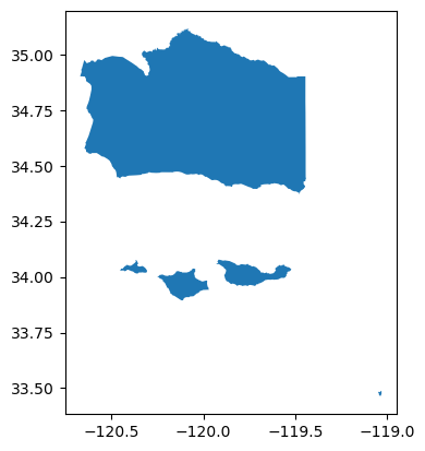
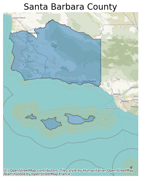
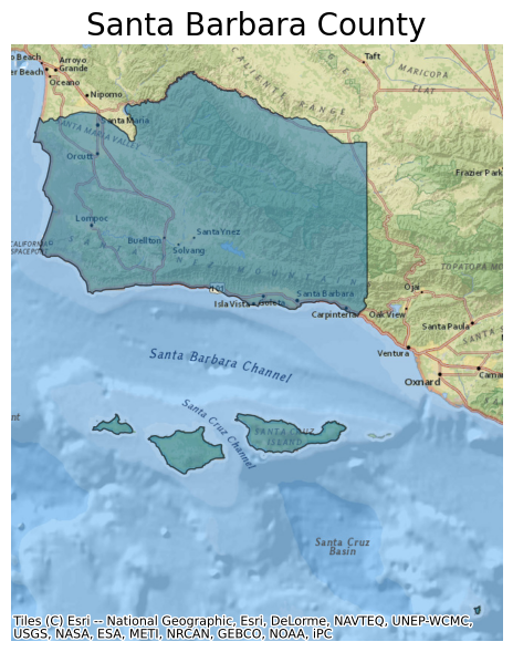
 New OneMap | Map data © contributors, Singapore Land Authority